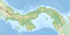
Panama, officially the Republic of Panama, is a transcontinental country in Central America and South America, bordered by Costa Rica to the west, Colombia to the southeast, the Caribbean Sea to the north, and the Pacific Ocean to the south. Its capital and largest city is Panama City, whose metropolitan area is home to nearly half the country's 4 million people.
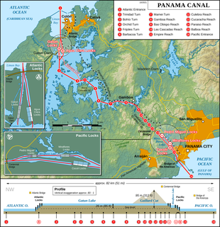
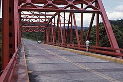
The Panama Canal is an artificial 82 km (51 mi) waterway in Panama that connects the Atlantic Ocean with the Pacific Ocean and divides North and South America. The canal cuts across the Isthmus of Panama and is a conduit for maritime trade. One of the largest and most difficult engineering projects ever undertaken, the Panama Canal shortcut greatly reduces the time for ships to travel between the Atlantic and Pacific oceans, enabling them to avoid the lengthy, hazardous Cape Horn route around the southernmost tip of South America via the Drake Passage or Strait of Magellan and the even less popular route through the Arctic Archipelago and the Bering Strait.

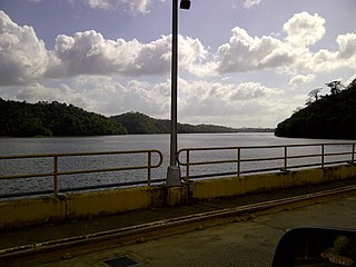
Gatun Lake is a large freshwater artificial lake to the south of Colón, Panama. It forms a major part of the Panama Canal, carrying ships 33 km (21 mi) of their transit across the Isthmus of Panama.
The Black Warrior River is a waterway in west-central Alabama in the southeastern United States. The river rises in the extreme southern edges of the Appalachian Highlands and flows 178 miles (286 km) to the Tombigbee River, of which the Black Warrior is the primary tributary. The river is named after the Mississippian paramount chief Tuskaloosa, whose name was Muskogean for 'Black Warrior'. The Black Warrior is impounded along nearly its entire course by a series of locks and dams to form a chain of reservoirs that not only provide a path for an inland waterway, but also yield hydroelectric power, drinking water, and industrial water.
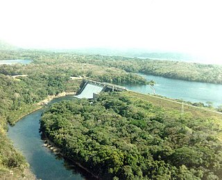
The Gatun Dam is a large earthen dam across the Chagres River in Panama, near the town of Gatun. The dam, constructed between 1907 and 1913, is a crucial element of the Panama Canal; it impounds the artificial Gatun Lake, which in turn carries ships 33 kilometres (21 mi) of their transit across the Isthmus of Panama. In addition, a hydro-electric generating station at the dam generates electricity which is used to operate the locks and other equipment in the canal.

The Chagres River, in central Panama, is the largest river in the Panama Canal's watershed. The river is dammed twice, and the resulting reservoirs—Gatun Lake and Lake Alajuela—form an integral part of the canal and its water system. Although the river's natural course runs northwest to its mouth at the Caribbean Sea, its waters also flow, via the canal's locks, into the Gulf of Panama to the south. The Chagres thus has the unusual claim of drainage into two oceans.

The Ngäbe are an indigenous people within the territories of present-day Panama and Costa Rica in Central America. The Ngäbe mostly live within the Ngäbe-Buglé comarca in the Western Panamanian provinces of Veraguas, Chiriquí and Bocas del Toro. They also have five indigenous territories in southwestern Costa Rica, encompassing 23,600 hectares: Coto Brus, Abrojos Montezuma, Conte Burica, Altos de San Antonio and Guaymi de Osa. In the early 21st century, there are approximately 200,000-250,000 speakers of the Ngäbere language.

The Cordillera de Talamanca is a mountain range that lies in the southeast half of Costa Rica and the far west of Panama. Much of the range and the area around it is included in La Amistad International Park, which also is shared between the two countries.

John Ripley Freeman was an American civil and hydraulic engineer. He is known for the design of several waterworks and served as president of both the American Society of Civil Engineers and the American Society of Mechanical Engineers.
Craugastor tabasarae is a species of frog in the family Craugastoridae. It is endemic to Panama and known from a few isolated records in the Veraguas, Coclé, Colón, and Panamá Provinces. The range includes the eponymous Serranía de Tabasará.
The Bayano Dam is a dam on the Bayano River in Darién Province, Panama. The dam was built in 1976; its construction flooded approximately 350 square kilometers of rainforest, displacing thousands of indigenous residents. The flooded area is now Bayano Lake. The dam is the second-largest power source in Panama.
Bayano Lake is a reservoir in the eastern part of Panamá Province, Panama created when the Bayano River was dammed in 1976. In terms of surface area, Lake Bayano is the second largest lake in Panama, exceeded only by Lake Gatun.
Bayano River is a river of Panama in the Panamá Province. It is an alternative name for the upper part of the Chepo River.

Starved Rock Lock and Dam, also known as Lock and Dam No. 6, is a lock and dam facility managed by the U.S. Army Corps of Engineers along the Illinois River. It is part of the Illinois Waterway and was constructed between 1926 and 1933. The lock and dam was added to the National Register of Historic Places as the Starved Rock Lock and Dam Historic District in 2004.
The Madden Dam, completed in 1935, impounds the Chagres River in Panama to form Lake Alajuela, a reservoir that is an essential part of the Panama Canal watershed. The lake has a maximum level of 250 feet (76 m) above sea level. It can store one third of the canal's annual water requirements for the operation of the locks. Since the reservoir is not part of the navigational route, there are fewer restrictions on its water level.

Barro Blanco is a gravity dam on the Tabasara River in the Chiriqui Province of Panama. It began generating in 2017 with capacity of 28.56 MW. Although the government had authorized the dam, it suspended construction in February 2015 after protests. The President of the Republic authorized the partial restart of construction in August 2015, but prohibited the filling of the reservoir pending a final agreement. Important issues concerning the dam are controversial, such as the question whether the indigenous communities in the area initially had expressed their support or their opposition to the dam's construction and how well they had been informed about the project and its impacts prior to expressing their views.
Sibon noalamina is a species of snail-eating snake discovered in 2012 from western Panama. It belongs to the genus Sibon. It has a striking defensive mechanism from predators by mimicking the light and dark stripes of venomous coral snakes.
The Bonyic Dam is a gravity dam on the Bonyic River, a tributary of the Teribe River about 24 km (15 mi) southwest of Changuinola in the Bocas del Toro province of northwestern Panama. The project produce hydroelectricity at a 32.64 MW power station about 3.8 km (2 mi) downstream of the dam. The builder and operator is Hidroécología Teribe (HET) S.A., a private Panamanian company whose majority stockholder is Empresas Públicas de Medellín (EPM), a public utility company owned by the municipal government of Medellín, Colombia. The dam construction was subject to controversies that have resulted in the removal of its funding by the Inter-American Development Bank. The Bonyic dam would obstruct access for migrating fish to La Amistad International Park. Members of the local indigenous people, the Naso, have periodically blockaded the single road to delay construction for a cumulative total of four years.