
The Sierra Nevada is a mountain range in the Western United States, between the Central Valley of California and the Great Basin. The vast majority of the range lies in the state of California, although the Carson Range spur lies primarily in Nevada. The Sierra Nevada is part of the American Cordillera, a chain of mountain ranges that consists of an almost continuous sequence of such ranges that form the western "backbone" of North America, Central America, South America and Antarctica.

Mono County (MOH-noh) is a county located in the east central portion of the U.S. state of California. As of the 2010 census, the population was 14,202. making it the fifth-least populous county in California. The county seat is Bridgeport. The county is located east of the Sierra Nevada between Yosemite National Park and Nevada.

Nevada County is a county in the Sierra Nevada of California. As of the 2010 census, the population was 98,764. The county seat is Nevada City.
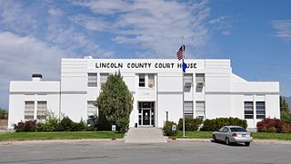
Lincoln County is a county located in the U.S. state of Nevada. As of the 2010 census, the population was 5,345. Its county seat is Pioche.

The Humboldt-Toiyabe National Forest (HTNF) is the principal U.S. National Forest in the U.S. state of Nevada, and has a smaller portion in Eastern California. With an area of 6,289,821 acres (25,454.00 km2), it is the largest National Forest of the United States outside Alaska.

The Black Rock Desert is a semi-arid region (in the Great Basin shrub steppe eco-region), of lava beds and playa, or alkali flats, situated in the Black Rock Desert–High Rock Canyon Emigrant Trails National Conservation Area, a silt playa 100 miles (160 km) north of Reno, Nevada that encompasses more than 300,000 acres (120,000 ha) of land and contains more than 120 miles (200 km) of historic trails. It is in the northern Nevada section of the Great Basin with a lakebed that is a dry remnant of Pleistocene Lake Lahontan.

The Northern Paiute people is a Numic tribe that has traditionally lived in the Great Basin in eastern California, western Nevada, and southeast Oregon. The Northern Paiutes' pre-contact lifestyle was well adapted to the harsh desert environment in which they lived. Each tribe or band occupied a specific territory, generally centered on a lake or wetland that supplied fish and water-fowl. Communal hunt drives, which often involved neighboring bands, would take rabbits and pronghorn from surrounding areas. Individuals and families appear to have moved freely among the bands.

The Humboldt River runs through northern Nevada in the western United States. At approximately 290 miles (470 km) long it is the third longest river in the Great Basin, after the Bear and Sevier Rivers. It has no outlet to the ocean, but instead empties into the Humboldt Sink. It is the fifth largest river in the United States, in terms of discharge, that does not ultimately reach the ocean, while it is the largest in terms of area drained. Through its tributaries the river drains most of sparsely populated northern Nevada, traversing the state roughly east to west, and passing through repeated gaps in the north-south running mountain ranges. It furnishes the only natural transportation artery across the Great Basin and has provided a route for historic westward migrations and subsequent railroads and highways. The river is named for the German naturalist Alexander von Humboldt.

Mount Charleston, officially named Charleston Peak, at 11,916 feet (3,632 m), is the highest mountain in both the Spring Mountains and Clark County, in Nevada, United States. It is the eighth-highest mountain in the state. Well separated from higher peaks by large, low basins, it is the most topographically prominent peak in Nevada, and the eighth-most-prominent peak in the contiguous United States. It is one of eight ultra-prominent peaks in Nevada. It is located about 35 miles (56 km) northwest of Las Vegas within the Mount Charleston Wilderness, which is within the Spring Mountains National Recreation Area of the Humboldt-Toiyabe National Forest.

Wheeler Peak is the tallest mountain in the Snake Range and in White Pine County, in Nevada, United States. The summit elevation of 13,065 feet (3,982 m) makes it the second-highest peak in Nevada, just behind Boundary Peak. With a topographic prominence of 7,563 feet (2,305 m), Wheeler Peak is the most topographically prominent peak in White Pine County and the second-most prominent peak in Nevada, just behind Mount Charleston. The mountain is located in Great Basin National Park and was named for George Wheeler, leader of the Wheeler Survey of the late 19th century.
A table mountain is a large table (landform) or mesa hence the name of numerous mountains around the world:
A list of highest points typically contains the name, elevation, and location of the highest point in each of a set of geographical regions. Such a list is important in the sport of highpointing. A partial list of highpoint lists is below:

The Table Mountain Wilderness is a protected wilderness area in the Monitor Range of Nye County in central section of the state of Nevada. It is the third largest wilderness area in the state. The nearest city is Tonopah, Nevada. The Table Mountain Wilderness Area covers 92,600 acres (37,500 ha), and is administered by the Humboldt-Toiyabe National Forest. The 1860s ghost town of Belmont is nearby.

Table Mountain is located near the northern end of the Great Western Divide, a sub-range of the Sierra Nevada in California. The summit marks a point on the boundary between Sequoia and Kings Canyon national parks and is 0.6 miles (1 km) south of Thunder Mountain and 1.3 miles (2.1 km) northeast of Midway Mountain.

The Northern Basin and Range ecoregion is a Level III ecoregion designated by the United States Environmental Protection Agency (EPA) in the U.S. states of Oregon, Idaho, Nevada, Utah, and California. It contains dissected lava plains, rolling hills, alluvial fans, valleys, and scattered mountain ranges in the northern part of the Great Basin. Although arid, the ecoregion is higher and cooler than the Snake River Plain to the north and has more available moisture and a cooler climate than the Central Basin and Range to the south. Its southern boundary is determined by the highest shoreline of Pleistocene Lake Bonneville, which once inundated the Central Basin and Range. The western part of the region is internally drained; its eastern stream network drains to the Snake River system.
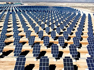
Solar power in Nevada is growing due to a Renewable Portfolio Standard which requires 20% renewable energy by 2015, and 5% from solar power. The state has abundant open land areas and some of the best solar potential in the country.

Table Mountain is a mountainous landscape feature in Tuolumne County, California near the town of Jamestown. Table Mountain is an inverted valley, a elevated landform which follows the former contours of a river valley above level of the surrounding topography, rather than below it. It was created by lava flows which filled an ancient river bed. The resulting igneous rock resisted erosion better that the materials around it, leaving behind a sinuous rock formation elevated above the surrounding landscape.
Thunder Mountain is located in the northern part of the Great Western Divide, a sub-range of the Sierra Nevada in California. The summit marks a point on the boundary between Sequoia and Kings Canyon national parks and is 0.6 miles (1 km) north of Table Mountain and south 2.8 miles (4.5 km) Mount Brewer. Thunder pass, on the mountains east side, has an elevation of 12,720+ feet. This pass marks the western end of the Kings-Kern Divide.

The Mountain States form one of the nine geographic divisions of the United States that are officially recognized by the United States Census Bureau. It is a subregion of the Western United States.


