
Lillie Glacier is a large glacier in Antarctica, about 100 nautical miles (190 km) long and 10 nautical miles (19 km) wide. It lies between the Bowers Mountains on the west and the Concord Mountains and Anare Mountains on the east, flowing to Ob' Bay on the coast and forming the Lillie Glacier Tongue.

The Usarp Mountains is a major Antarctic mountain range, lying westward of the Rennick Glacier and trending N-S for about 190 kilometres (118 mi). The feature is bounded to the north by Pryor Glacier and the Wilson Hills. Its important constituent parts include Welcome Mountain, Mount Van der Hoeven, Mount Weihaupt, Mount Stuart, Mount Lorius, Smith Bench, Mount Roberts, Pomerantz Tableland, Daniels Range, Emlen Peaks, Helliwell Hills and Morozumi Range.

Blackfoot Glacier is the second largest of the remaining 25 glaciers in Glacier National Park, Montana. Blackfoot Glacier is just to the north of Blackfoot Mountain and near Jackson Glacier. The glacier was most recently measured in 2005 at 441 acres (1.78 km2), yet when first documented in 1850, the glacier also included the now separate Jackson Glacier and together, they covered 1,875 acres (7.59 km2). In 1850, there were an estimated 150 glaciers in the park. Glaciologists have stated that by the year 2030, all the glaciers in the park may disappear. However, under a modest increase in overall carbon dioxide levels, some glaciers will remain until the late 23rd century.

Mount Warren is located in the Wind River Range in the U.S. state of Wyoming. The peak is the third peak in the range and the fourth tallest in Wyoming. The summit is located in the Fitzpatrick Wilderness of Shoshone National Forest and rises above several glaciers, the best known being Dinwoody Glacier which is immediately north of the summit tower. The mountain abuts, but is not within, either Bridger National Forest or Sublette County, Wyoming.
Turret Peak is the sixth-highest peak in the U.S. state of Wyoming and the fifth-highest in the Wind River Range. The Dinwoody Glacier is located on the northwest slope of the mountain, while the Helen Glacier is to the south. Turret Peak is estimated to be between 13,606 to 13,646 feet high.
Mount Woodrow Wilson is located in the Wind River Range in the U.S. state of Wyoming. Mount Woodrow Wilson is the eighth-highest mountain in the range and the ninth-highest in Wyoming. The summit is located in the Bridger Wilderness of Bridger-Teton National Forest on the Continental Divide, 1.25 miles (2.01 km) south of Gannett Peak. The flanks of the mountain are covered in snowfields and glaciers, including Dinwoody Glacier to the northeast, Mammoth Glacier to the west and Sphinx Glacier to the south.
Bastion Peak, at 13,500 feet (4,100 m), is located in the Wind River Range in the U.S. state of Wyoming. The peak is the ninth-highest in the range and the tenth-highest in Wyoming. The summit is located on the Continental Divide and the eastern slopes of the mountain are covered by a section of Gannett Glacier, the largest glacier in the American Rocky Mountains. An arête to the northeast leads to Bastion Peak-Northeast Peak, which, at 13,476 ft (4,107 m), is also one of the highest points in Wyoming.
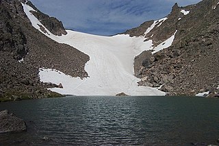
Andrews Glacier is an alpine glacier in a cirque below Otis Peak in Rocky Mountain National Park in the U.S. state of Colorado. The glacier extends from Andrews Pass at nearly 12,000 to 11,700 feet with some perennial snow extending to Andrews Tarn, a small proglacial lake. When images of the glacier taken in the early 1900s are compared with those of the early 2000s, Andrews Glacier is showing a negative glacier mass balance which indicates the glacier is retreating.

Rippon Glacier is a small glacier located in Kemp Land, East Antarctica. It is close east of Seaton Glacier, flowing southward into Edward VIII Ice Shelf.

Long Glacier is a glacier about 8 nautical miles long in the southeastern part of Thurston Island, Antarctica. It flows south to the Abbot Ice Shelf, 14 nautical miles (26 km) west of Harrison Nunatak. The glacier was mapped by the United States Geological Survey from surveys and U.S. Navy air photos, 1960–66, and was named by the Advisory Committee on Antarctic Names (US-ACAN) for Fred A. Long, Jr., an aviation machinist of U.S. Navy Squadron VX-6, who wintered at Little America V in 1957 and was in Antarctica in the 1960–61 and 1962–63 seasons.
Mahaffey Glacier is a glacier flowing into the head of Morgan Inlet at the east end of Thurston Island, Antarctica. It was named by the Advisory Committee on Antarctic Names after J.S. Mahaffey, a Photographer's Mate in the Eastern Group of U.S. Navy Operation Highjump, which obtained aerial photographs of Thurston Island and adjacent coastal areas in 1946–47.

Mills Glacier is an alpine glacier near the base of the east mountain face of Longs Peak, in Rocky Mountain National Park in the U.S. state of Colorado.
Moomaw Glacier is an alpine glacier in Rocky Mountain National Park in the U.S. state of Colorado. Moomaw Glacier is almost 1 mi (1.6 km) northeast of Isolation Peak and the old terminal moraine of the glacier impounds Frigid Lake.
Rowe Glacier is an alpine glacier in Rocky Mountain National Park in the U.S. state of Colorado. Rowe Glacier is 300 yd (270 m) north of Hagues Peak and is the source of the North Fork Big Thompson River. Rowe Glacier was the first glacier to be identified in Colorado.
The Saint Vrain Glaciers are small alpine glaciers located in Roosevelt National Forest in the U.S. state of Colorado. The glaciers are just south of Rocky Mountain National Park and east of the Continental Divide in northeast facing cirques.

Sandalee Glacier is in North Cascades National Park and Lake Chelan National Recreation Area in the U.S. state of Washington, on the north and east slopes of McGregor Mountain. Sandalee Glacier originates in several cirques and extends from 7,800 to 6,800 ft above sea level across a distance of almost 1.5 mi (2.4 km). The National Park Service is currently studying Sandalee Glacier as part of their glacier monitoring project.

Queest-alb Glacier is in Snoqualmie National Forest in the U.S. state of Washington, on the west slopes of Three Fingers. Queest-alb Glacier is also known as Three Fingers Glacier, but neither name is officially recognized by the United States Geological Survey. The glacier descends from 6,400 to 5,000 ft and is a popular location for skiing.
Downs Mountain is located in the Wind River Range in the U.S. state of Wyoming. Downs Mountain is the 15th highest peak in Wyoming. The summit is on the Continental Divide in both Shoshone and Bridger-Teton National Forests. The East Torrey Glacier is on the northern slopes of Downs Mountain, while Continental Glacier lies to the west and north and the Downs Glacier is 1 mi (1.6 km) to the south.
Knife Point Mountain is located in the northern Wind River Range in the U.S. state of Wyoming. Situated 2.7 mi (4.3 km) southeast of Fremont Peak, Knife Point Mountain is on the Continental Divide. North of Knife Point Mountain is the origination point of Knife Point Glacier, while Harrower Glacier lies just to the west. Knife Point Mountain is the 32nd tallest peak in Wyoming.
Split Mountain is located in the Wind River Range in the U.S. state of Wyoming. Split Mountain is the 22nd highest peak in Wyoming. Split Mountain is in the Bridger Wilderness of Bridger-Teton National Forest and is about .70 mi (1.13 km) northwest of Twin Peaks and 1 mi (1.6 km) southeast of Mount Whitecap. Mammoth Glacier is on the northeast slopes of the peak while the smaller Baby Glacier flows down from a spur to the northwest.


