Victoria Island is a large island in the Arctic Archipelago that straddles the boundary between Nunavut and the Northwest Territories of Canada. It is the eighth-largest island in the world, and at 217,291 km2 (83,897 sq mi)1 in area, it is Canada's second-largest island. It is nearly double the size of Newfoundland (111,390 km2 [43,010 sq mi]), and is slightly larger than the island of Great Britain (209,331 km2 [80,823 sq mi]) but smaller than Honshu (225,800 km2 [87,200 sq mi]). The western third of the island lies in the Inuvik Region of the Northwest Territories; the remainder is part of Nunavut's Kitikmeot Region. The population of 2,168 is divided between two settlements, the larger of which is Cambridge Bay (Nunavut) and the other Ulukhaktok.

The Arctic Archipelago, also known as the Canadian Arctic Archipelago, is an archipelago lying to the north of the Canadian continental mainland, excluding Greenland and Iceland.

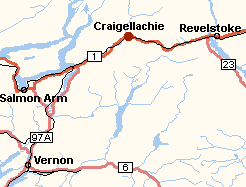
Craigellachie is a locality in British Columbia, located several kilometres to the west of the Eagle Pass summit between Sicamous and Revelstoke. Craigellachie is the site of a tourist stop on the Trans-Canada Highway between Salmon Arm and Revelstoke.

Coombs is a small community on Vancouver Island in the Regional District of Nanaimo, British Columbia, situated on provincial highway 4A approximately 10 km (6.2 mi) west of Parksville. According to the 2021 census, Coombs is home to 1672 people.

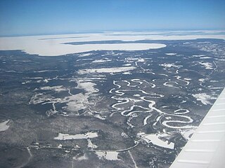
Unorganized North Algoma District is an unorganized area in northeastern Ontario, Canada, comprising all areas in Algoma District, north of the Sault Ste. Marie to Elliot Lake corridor, which are not part of an incorporated municipality or a First Nation. It covers 44,077.03 km2 (17,018.24 sq mi) of land, and had a population of 6050 in 2021. Many of these communities were/are stations on the Algoma Central Railway or were logging/mining towns.

Athabasca Pass is a high mountain pass in the Canadian Rockies on the border between Alberta and British Columbia. In fur trade days it connected Jasper House on the Athabasca River with Boat Encampment on the Columbia River.

Cherryville is an unincorporated community in the foothills of the Monashee Mountains in British Columbia with a population of approximately 930. It is located 22 kilometres (14 mi) east of Lumby, along Highway 6.
Downing Provincial Park is a provincial park in British Columbia, Canada, created when Mr. and Mrs. Clair Downing donated their half-mile of lake frontage property on Kelly Lake. The park's size, including the 97 acres (0.39 km2) donated by the Downings, is 156 hectares. It is located adjacent to the British Columbia Railway line and the Pavilion Mountain Road about 30 km west of Clinton, at the junction with the road to Jesmond and Kostering.
Granby Provincial Park is a provincial park in British Columbia, Canada. It is located north of Grand Forks and contains the northern portion of the Granby River. The park is 411.56 km2 in size.
Shuswap Lake Marine Provincial Park is a provincial park in British Columbia, Canada, comprising 894 ha. The Park has a variety of amenities including boat launch ramps, picnic areas, and 27 campsites around the perimeter of Shuswap Lake. The lake's name and that of the surrounding Shuswap Country is from the Shuswap people (Secwepemc), the most northern of the Salishan speaking people.
Silver Beach Provincial Park is a provincial park in British Columbia, Canada, located at the head of the Seymour Arm of Shuswap Lake in that province's Shuswap Country, adjacent to the settlement of Seymour Arm.

Greenwood is a city in south central British Columbia. It was incorporated in 1897 and was formerly one of the principal cities of the Boundary Country smelting and mining district. It was incorporated as a city originally and has retained that title despite the population decline following the closure of the area's industries.

Midway is in the West Kootenay region of south central British Columbia. The village lies 13 kilometres (8 mi) west of Greenwood and 51 kilometres (32 mi) east of Osoyoos along Highway 3.
Saltcoats is a town in east-central Saskatchewan near the Manitoba border in Canada. The town's population was 474 in 2011. It was built in the late 19th century, and its economy was driven by the railway. There is no longer a passenger service to the town.
Clairmont is a hamlet in northern Alberta, Canada within the County of Grande Prairie No. 1. Previously an incorporated municipality, Clairmont dissolved from village status on January 1, 1946 to become part of the Municipal District of Bear Lake No. 740.
Silverdale is a semi-rural neighbourhood of the District of Mission, British Columbia, Canada, located about 40 km east of Vancouver on the east bank of the Stave River at its confluence with the Fraser. Noted for its historic Italian Canadian community, its economy was farming, fishing and logging based until the general suburbanization of Fraser Valley life in the 1960s and 1970s. Of its Italian community, notable offspring include Phil Gaglardi, former BC Highways minister, and speed-skater Eden Donatelli. Silverdale is also notable as the site of Canada's first train robbery, by the "Gentleman Bandit" Billy Miner, and it is there he is supposed to have first used the polite "Hands Up!" in the course of the robbery.

Alouette Lake, originally Lillooet Lake and not to be confused with the lake of that name farther north, is a lake and reservoir in Maple Ridge, British Columbia, Canada. It is at the southeastern foot of the mountain group known as the Golden Ears and is about 16 km in length on a northeast–southwest axis. It, and the Alouette River, were renamed in 1914 to avoid confusion with the larger river and lake farther north, with "Alouette", the French word for "lark", being chosen as being melodious and reminiscent of the original name in tone.
The Ratchford Range is a subrange of the Monashee Mountains of the Columbia Mountains, located east of the Seymour River in British Columbia, Canada.
Cascade Falls is a waterfall on the Kettle River in the Boundary Country of the Southern Interior of British Columbia. They are located just south of Christina Lake and just north of the Canada–United States border in a gorge 200-300 yards long and just below the railway bridge over the Kettle by the southern mainline of the Canadian Pacific Railway. The ghost town of Cascade City aka Cascade is nearby and was named for the falls, even though they were not officially named until 1977.


