
Myanmar is the northwesternmost country of mainland Southeast Asia located on the Indochinese peninsula. With an area of 261,228 sq mi (676,578 km2), it is the second largest country in Southeast Asia and the largest on mainland Southeast Asia. The kite-shaped country stretches from 10'N to 20'N for 1,275 miles (2,050 km) with a long tail running along the western coast of the Malay Peninsula.

The Malay Peninsula is located in Mainland Southeast Asia. The landmass runs approximately north–south, and at its terminus, it is the southernmost point of the Asian continental mainland. The area contains Peninsular Malaysia, Southern Thailand, and the southernmost tip of Myanmar (Kawthaung). The island country of Singapore also has historical and cultural ties with the region.
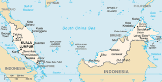
The geography of Malaysia includes both the physical and the human geography of Malaysia, a Southeast Asian country made up of two major landmasses separated by water—Peninsular Malaysia to the west and East Malaysia to the east—and numerous smaller islands that surround those landmasses. Peninsular Malaysia is on the southernmost part of the Malay Peninsula, south of Thailand, north of Singapore and east of the Indonesian island of Sumatra; East Malaysia comprises most of the northern part of Borneo, and shares land borders with Brunei to the north and Indonesian Borneo to the south.

Mount Tahan, is the highest point in Peninsular Malaysia with an elevation of 7,175 ft (2,187 m) above sea level, on the border between the states of Pahang and Kelantan, with the peak lying on the Pahangese side. It is part of the Taman Negara that straddles Jerantut District in Pahang, Gua Musang District in Kelantan and Hulu Terengganu District in Terengganu. The mountain is part of the Tahan Range in the Tenasserim Hills and is popular with local climbers.

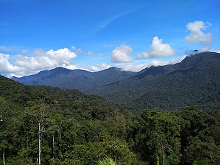
Taman Negara is a national park in Peninsular Malaysia. It was established in 1938 and 1939 as the King George V National Park after Theodore Hubback lobbied the sultans of Pahang, Terengganu and Kelantan to set aside a piece of land that covers the three states for the creation of a protected area. After independence, it was renamed Taman Negara, which means "national park" in Malay.
The Titiwangsa Mountains, also known as Banjaran Besar by locals, is the chain of mountains that forms the backbone of the Malay Peninsula. The northern section of the range is in southern Thailand, where it is known as the Sankalakhiri Range.

The Bintang Mountains is a mountain range, part of the Tenasserim Hills, that encompasses the states of Kedah and Perak, Malaysia. It runs from the province of Yala, southern Thailand in the north, straddling along the Kedah–Perak border and ends in the south near Beruas, Manjung District, western Perak. Within Perak, the mountain range forms a natural boundary between the districts of Kuala Kangsar and Hulu Perak in the east and Larut, Matang and Selama in the west. It borders the Titiwangsa Mountains, Peninsular Malaysia's chief mountain range, to its east. The range divides the basins of Kerian and Perak Rivers in the west and east respectively.

The Jerantut District is a district in north-eastern Pahang, Malaysia. Jerantut is home to the National Park.

Nepenthes benstonei is a tropical pitcher plant endemic to Peninsular Malaysia, where it grows at elevations of 150–1350 m above sea level. The specific epithet benstonei honours botanist Benjamin Clemens Stone, who was one of the first to collect the species.

Mount Korbu is a mountain in Hulu Kinta, Perak, Malaysia, about 25 km from Ipoh. It is the highest peak in the state of Perak, located on the Titiwangsa Mountains, the southernmost section of the Tenasserim Hills.
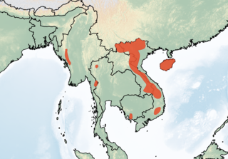
The Tenasserim white-bellied rat is a species of rodent in the family Muridae. It is named after the Tenasserim Hills and is found above 1,000 m in forested limestone mountainous areas. Its distribution includes India, Myanmar, Thailand, Cambodia (southern end of the Cardamom Mountains, Laos and Vietnam, and China.
Budo–Su-ngai Padi National Park is a national park in Narathiwat Province, Thailand. It is part of Sankala Khiri mountain range, the southernmost subrange of the Tenasserim Hills.
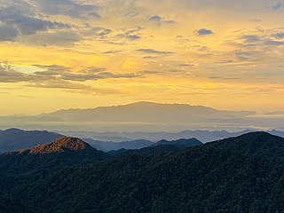
The Tenasserim Hills or Tenasserim Range is the geographical name of a roughly 1,700 km long mountain chain, part of the Indo-Malayan mountain system in Southeast Asia.

The Karen Hills, also known as Kayah-Karen Mountains, are one of the main hill ranges in eastern Burma. They are located at the SW corner of Shan State and in Kayah State, a mountainous region where the only relatively flat area is Loikaw, the capital. The southern end runs into Kayin State. One of the first all-weather roads in Burma was across the Karen Hills connecting Taungoo with Loilem.
Ulu Titi Basah is the southernmost high peak of Thailand. The peak is 1,533 metres (5,030 ft) tall and is located on the Malaysia–Thailand border between Betong District of Yala province and Hulu Perak in the state of Perak.

The Phuket Range is a subrange of the Tenasserim Hills in the Kra Isthmus, Thailand.
Mount Benum or Mount Benom is a mountain in the state of Pahang in Malaysia. Its summit is 2,107 m (6,913 ft) above sea level. The mountain is located in a centre of an isolated massif east of the Titiwangsa Mountains.

The Dawna Range, also known as Dawna Hills, is a mountain range in eastern Burma and northwestern Thailand. Its northern end is located in Kayah State where it meets the Daen Lao Range, a subrange of the Shan Hills. The range runs southwards along Kayin State as a natural border with Mon State in the west forming parallel ranges to the northern end of the Tenasserim Hills further south and southeast. The Dawna Range extends east of the Salween southwards from the Shan Hills for about 350 km, at the western limit of the Thai highlands. Its southern end reaches the Thai-Myanmar border in the Umphang area, entering Thailand west of Kamphaeng Phet. The Thungyai Naresuan Wildlife Sanctuary is in the Thai side of the range.

The Peninsular Malaysian montane rain forests is an ecoregion on the Malay Peninsula. It occupies the mountainous spine of the peninsula in Malaysia and southernmost Thailand. It is in the tropical and subtropical moist broadleaf forests biome.
The Pantai Timur Range, also known as the Terengganu Highlands, is a mountain range situated in the eastern seaboard of Peninsular Malaysia. It is a subrange of the wider Tenasserim Hills system, that defines the backbone of the Malay Peninsula. The Pantai Timur Range covers Machang, Gua Musang and Kuala Krai Districts in southeastern Kelantan, the western frontier of Terengganu, and Jerantut and Kuantan Districts in northeastern Pahang.
