Related Research Articles

The K’ómoks or K'omoks, usually known in English as the Comox people, are an indigenous group of Coast Salishan-speaking people in Comox, British Columbia and in Toba Inlet and the Malaspina Peninsula areas of the British Columbia mainland across Georgia Strait. They historically spoke the Komox language (Comox-Sliammon), and were divided in two main dialect and tribal groupings, which are known by academics as Island Comox and Mainland Comox.

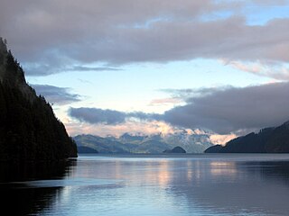
Bute Inlet is one of the principal inlets of the British Columbia Coast. It is 80 km (50 mi) long from the estuaries of the Homathko and Southgate Rivers at the head of the inlet, to the mouth, where it is nearly blocked by Stuart Island, and it averages about 4 km (2.5 mi) in width. Bute Inlet is in a spectacular wilderness setting and is one of the most scenic waterways in the world. In the upper reaches of the inlet mountains rise 2,700 m (9,000 ft) feet above sea level. Bute Inlet is a spectacular wilderness that is visited by very few people. In more recent years tourists are travelling from around the world to view grizzly bears in a natural setting and explore the wilderness of Bute Inlet.
Toba Inlet is one of the lesser, but still principal, inlets of the British Columbia Coast. It is fourth in the series north from the 49th parallel which begins with Burrard Inlet, which is the harbour for the city of Vancouver. Between it and Jervis Inlet to its east, however, there is a freshwater fjord, Powell Lake, which has been augmented by a small hydro project to supply power to the large pulp mill at Powell River, the principal town of the Malaspina Peninsula of the upper Sunshine Coast. Klahoose 1 Reserve, of the Klahoose First Nation is at the mouth of Toba River at the Head of Toba Inlet. Toba Inlet and the Toba Valley is home to many grizzly bears.
Bishop River Provincial Park is a provincial park in the Pacific Ranges of the Coast Mountains on the Mainland of British Columbia, Canada, located southwest of and adjoining Ts'yl-os Provincial Park."Bishop River Park". BC Geographical Names. It lies along the upper course of the Bishop River, the main tributary of the Southgate River, from the Bishop's source at the western side of the Lillooet Icecap to midway along its course above its confluence with the Southgate. The park is 19,947 ha. in size. There are no roads or trails in the park although a forest service road from Waddington Harbour at the head of Bute Inlet leads up the Southgate to within a few miles of the park boundary.
von Donop Marine Provincial Park, formerly Von Donop Marine Provincial Park, is a provincial park in British Columbia, Canada, located on the north end of Cortes Island in the Discovery Islands.
Homathko Estuary Provincial Park is a provincial park in British Columbia, Canada, located at the head of Bute Inlet surrounding the mouth of the Homathko River in the Pacific Ranges of the Coast Mountains.
The Lillooet Icecap, also called the Lillooet Icefield or the Lillooet Crown, is a large icefield in the Pacific Ranges of the Coast Mountains in southwestern British Columbia, Canada. It is about 90 km (56 mi) northwest of the towns of Pemberton and Whistler, and about 175 km (109 mi) north of Vancouver, British Columbia. The Lillooet Icecap is one of the largest of several large icefields in the Pacific Ranges which are the largest temperate-latitude glacial fields in the world. At its maximum extent including its glacial tongues it measures 30 km (19 mi) east to west and 20 km (12 mi) north to south; its central icefield area is approximately 15 km (9 mi) in diameter.
The ƛoʔos Klahoose are one of the three groups comprising the ʔayʔaǰuθəm Tla'Amin or Mainland Comox. The other two divisions of this once-populous group are the χʷɛmaɬku Homalco and Sliammon. The Klahoose, Homalco and Sliammon are, according to oral tradition, the descendants of the survivors of the Great Flood. The three groups were split by colonialism into different band councils but united historically as the Tla A'min, known as the Mainland Comox, and K’ómoks, the larger grouping of the Comox people, also known as the Island Comox and before the merger with the Laich-kwil-tach culture. Historically both groups are a subgroup of the Coast Salish though the K’ómoks name is from, and their language today, is the Lik'wala dialect of Kwak'wala. The ancestral tongue is the Comox language, though the Sahtloot/Island dialect is extinct.
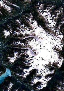
The Homathko Icefield is an icefield in British Columbia, Canada. Officially named the Homathko Snowfield from 1950 until the current name was adopted in 1976, it is one of the largest icefields in the southern half of the Coast Mountains, with an area of over 2,000 km2 (770 sq mi). It is located between Chilko Lake and the Homathko River, and lies across the Great Canyon of that river to the east of the Waddington Range. Although adjacent to Mount Queen Bess, the Homathko Icefield is largely an expanse of ice, about 30 km (19 mi) across, ringed by relatively minor peaks and distinguished, relative to the other Coast Mountains icefields, by lack of any major ones. The Lillooet Icecap and the Compton Névé, both similar in size to the Homathko Icefield but much more peak-studded, lie to the Homathko Icefield's southeast across the Southgate River which bends around the icefield-massif's southern flank to reach the head of Bute Inlet adjacent to the mouth of the Homathko River. The icefield is essentially one large ice-girt montane plateau between these two rivers.

West Redonda Island is an island in British Columbia, Canada. It is part of the Discovery Islands, an archipelago between Vancouver Island and the mainland, and between the Strait of Georgia and Johnstone Strait.
The Toba River is a river in the Canadian province of British Columbia. Also referred to as the East Toba river. Its drainage basin is 1,759 square kilometres (679 sq mi) in size.
The Malaspina Peninsula is a peninsula in the northern Gulf of Georgia-Sunshine Coast region of British Columbia, Canada. It extends northwest from the town of Powell River, which lies near its isthmus, past the settlement of Lund, to Desolation Sound. This sound spans the opening of Toba Inlet, a fjord lying between Lund and the Discovery Islands to the west and northwest.
The Skwawka River is a medium-sized river in the Pacific Ranges of the Coast Mountains in British Columbia, Canada, flowing southeast 20 kilometers (12 mi) into the head of Queens Reach, which is the uppermost end of Jervis Inlet. The pass at the head of the river, which connects to the head of the Little Toba River, is the prominence col for Mount Alfred, which lies just west of the river's mouth and is the highest summit between Jervis and Toba Inlets. Above the river's lower reaches, on the east flank of Mount Alfred, is 700 meters (2,300 ft) Alfred Creek Falls, one of North America's highest.
The Toba Montrose General Partnership (TMGP) is a 40/60 partnership between Alterra Power and GE Energy Financial Services that owns the Toba Montrose hydroelectric project, located near Powell River, British Columbia on the traditional lands of our First Nations partners: the Klahoose, Sliammon and Sechelt First Nations. The TMGP plants at East Toba River and Montrose Creek are British Columbia's largest run of river hydro plants. They have combined capacity of 196 MW and are expected to generate an average net annual energy of 710-730 GWh, which is contracted to B.C. Hydro under a 35-year EPA.

Alterra Power Corp. a subsidiary of Innergex Renewable Energy Inc., is a diversified renewable power generation company based in Vancouver, British Columbia, Canada. It was formed in 2011 through the merger of Magma Energy Corp. and Plutonic Power Corp. It develops, owns, acquires and operates hydroelectric, wind, solar energy and geothermal projects. On February 6, 2018, Innergex Renewable Energy Inc. completed the acquisition of Alterra including all its assets.
Theodosia Inlet is an inlet in the Desolation Sound region of the South Coast region of British Columbia, Canada, located east of Lancelot Inlet, a sub-inlet of Malaspina Inlet. The inlet is fed by the Theodosia River. The locality of Theodosia Arm is located near its outlet at the head of Thors Cove.
Malaspina Inlet is an inlet on the east side of Desolation Sound in the South Coast region of British Columbia, Canada, located between Malaspina and Gifford Peninsulas. Sidewaters include Thors Cove and, via it, Theodosia Inlet, where the locality of Theodosia Arm is located. The upper, southeastern, end of Malaspina Inlet near the City of Powell River is called Okeover Inlet. on the east side of which the steamer landing Larsons Landing is located. Grace Harbour is located on north side of Malaspina Inlet on the southwest side of Gifford Peninsula.
Grace Harbour is a harbour and traditional village site of the Tla'Amin peoples in the South Coast of British Columbia, located near Desolation Sound on the south side of the Gifford Peninsula opposite the Malaspina Peninsula to the southwest. Along with the Gifford Peninsula, it is part of Desolation Sound Marine Provincial Park. Kahkaykay Indian Reserve No. 6 was located on the west side of the harbour but as of 2011 is now fee-simple land as a result of the Sliammon Treaty. at 50°02′58″N124°45′21″W The headland at the southwest corner of the harbour is similarly named from the name of the ancient village at this site, Kakaekae Point, at 50°02′32″N124°45′56″W
Waddington Harbour is a harbour at the head of Bute Inlet in the Central Coast region of British Columbia, Canada. Also issuing into the head of Bute Inlet and Waddington Harbour, just east of the mouth of the Homathko, is the Teaquahan River. Issuing directly into the inlet a few miles south on the harbour's southeast is the Southgate River, one of the major rivers of the central Pacific Ranges, which begins on the west side of the Lillooet Icecap. Its lower valley adjacent to the inlet's shores is called Pigeon Valley.
Independent Power Producer (IPP) projects have had a significant presence in British Columbia since the 1980s. Their relationship with BC Hydro grew from the province's need to supply growing energy demands and implementation of the 2002 Energy Strategy, which mandated that BC Hydro would purchase its energy supply from IPPs rather than generating the supply itself. There are a variety of power projects in BC, with the most popular being hydroelectricity and biomass projects. In recent years, more attention has been placed on the environmental effects of IPP projects and the social implications it has to residents living around the project development sites. Despite the decline in demand for new IPP projects, in 2016 they supplied 20,000 GWh, one-third of BC Hydro's total.
References
- ↑ BC Names/GeoBC entry "Tahumming River"
- ↑ "Alterra and Klahoose To Develop Tahumming River Project". CNW. 12 May 2015. Retrieved 2018-09-20.
Coordinates: 50°29′34″N124°23′16″W / 50.49278°N 124.38778°W