Location
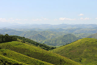
The Tainhas State Park is divided between the municipalities of Jaquirana, São Francisco de Paula and Cambará do Sul in the northeast region of the Rio Grande do Sul. The administrative center is in São Francisco de Paula. It has an area of 6,654.67 hectares (16,444.0 acres). It protects Atlantic Forest remnants in the state, including the ecosystems of the meadows of Cima da Serra and the forests of the valley of the Tainhas River. Vegetation includes forest with araucarias, upland meadows and plains. The terrain includes relatively flat areas and valleys with steep slopes. As of 2016 the park was not open to visitors.
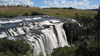
The park holds the Passo do S Waterfall, in the municipality of Jaquirana, where the Tainhas River runs over an S-shaped ledge. The falls are 80 metres (260 ft) wide and 15 metres (49 ft) high. Hunting, fishing and camping around the falls are prohibited. When the river is low, it is possible to cross the Passo do S on horseback or on foot.

São Francisco de Paula is a city in the Serra Gaúcha of the state of Rio Grande do Sul, Brazil. The municipality covers about 3,289.7 km2 (1,270.2 sq mi) and sits about 112 km (70 mi) from Porto Alegre. As of 2020, the city's population was estimated to be 21,801. The municipality was originally created on December 23, 1902.

The Jacuí River is a river in Rio Grande do Sul state of southern Brazil. The Jacuí empties into the Guaíba River, an estuarine arm of the Lagoa dos Patos, a large coastal lagoon connected to the Atlantic Ocean.

Cambará do Sul is a municipality in the state of Rio Grande do Sul, Brazil. Its population was approximately 6,406 in 2020. It has an area of approximately 1212 km2.

Jaquirana is a municipality in the state of Rio Grande do Sul, Brazil. As of 2020, the estimated population was 3,662.
Rio Tainhas is a river in the state of Rio Grande do Sul, Brazil. It is a left tributary of the Das Antas River

The Três Picos State Park is a state park in the state of Rio de Janeiro, Brazil. It preserves a large, mountainous region of Atlantic Forest.

The Cachoeira da Fumaça State Park is a state park in the state of Espírito Santo, Brazil, known for a dramatic waterfall. Visitors may swim in the pools.

The Turvo State Park is a state park in the state of Rio Grande do Sul, Brazil. It protects the last large area of well-preserved Upper Uruguay forest in the state, which is home to several rare or endangered species. The park is best known for the dramatic Yucumã Falls on the Uruguay River, the second-widest in the world by some measures. The falls may be threatened by flooding from the planned Garabí-Panambi Hydroelectric Complex if a 2015 court ruling is overturned.
The Pau Oco State Park is a state park in the state of Paraná, Brazil. It protects an area of Atlantic Forest. The main attraction is the Salto da Fortuna, a waterfall.
The Rio Turvo State Park is a state park in the state of São Paulo, Brazil. It protects an area of Atlantic Forest. A man's skeleton from 9,000 years ago was found in the park area in 1999.

The Biribiri State Park is a state park in the state of Minas Gerais, Brazil. It protects a mountainous region of cerrado. The park contains an abandoned village, once home to workers in a textile factory, which is now a tourist attraction.

The Guartelá State Park is a state park in the state of Paraná, Brazil. It protects the Guartelá Canyon, its surroundings and the area's natural environment.

The Itapeva State Park is a state park in the state of Rio Grande do Sul, Brazil.

The Carlos Botelho State Park is a state park is the state of São Paulo, Brazil. It protects a mountainous area of Atlantic Forest. The park contains more than half of Brazil's remaining population of endangered southern muriqui, the largest primate in the Americas other than man.

The Serra Azul State Park is a state park in the state of Mato Grosso, Brazil. It protects a mountainous area of cerrado forest and contains slopes that are used for paragliding. The park contains the geodetic center of Brazil.
The Nascentes do Rio Taquari State Park is a state park in the state of Mato Grosso do Sul, Brazil. It protects the headwaters of the Taquari River in an area in the transition between the cerrado and pantanal biomes.
The Pedra Branca State Park is a state park in the state of Rio de Janeiro, Brazil. It is one of the largest urban nature parks in the world. It protects an area of Atlantic Forest in the west of the city of Rio de Janeiro that includes the highest point in the city, the Pico da Pedra Branca.

The Espigão Alto State Forest Park is a state park in the state of Rio Grande do Sul, Brazil. It protects an area of old forest of which araucarias are the most prominent species.
The Serra da Concórdia State Park Portuguese: Parque Estadual da Serra da Concórdia is a state park in the state of Rio de Janeiro, Brazil. It protects an area of Atlantic Forest.

The Rio Vermelho State Park Portuguese: Parque Estadual do Rio Vermelho is a state park in the state of Santa Catarina, Brazil. It protects an area of restinga, dense rainforest and land modified by exotic plantations which is to be restored. The park provides a green space for visitors from the nearby state capital of Florianópolis. It features an ecological trail where visitors may see and learn about wild animals rescued from abuse by the environmental police.
This page is based on this
Wikipedia article Text is available under the
CC BY-SA 4.0 license; additional terms may apply.
Images, videos and audio are available under their respective licenses.

