
Rio Grande do Sul is a state in the southern region of Brazil. It is the fifth-most populous state and the ninth-largest by area. Located in the southernmost part of the country, Rio Grande do Sul is bordered clockwise by Santa Catarina to the north and northeast, the Atlantic Ocean to the east, the Uruguayan departments of Rocha, Treinta y Tres, Cerro Largo, Rivera, and Artigas to the south and southwest, and the Argentine provinces of Corrientes and Misiones to the west and northwest. The capital and largest city is Porto Alegre. The state has the highest life expectancy in Brazil, and the crime rate is relatively low compared to the Brazilian national average. Despite the high standard of living, unemployment is still high in the state, as of 2017. The state has 5.4% of the Brazilian population and it is responsible for 6.6% of the Brazilian GDP.

São Francisco de Paula is a city in the Serra Gaúcha of the state of Rio Grande do Sul, Brazil. The municipality covers about 3,289.7 km2 (1,270.2 sq mi) and sits about 112 km (70 mi) from Porto Alegre. As of 2020, the city's population was estimated to be 21,801. The municipality was originally created on December 23, 1902.

Rio Grande is a municipality (município) and one of the oldest cities in the Brazilian state of Rio Grande do Sul. It was the state capital from 1835 to 1845. It is the most important port city in the state and has one of the most important maritime ports in Brazil.
Rio Carreiro is a river in the state of Rio Grande do Sul in Brazil. The source of the river is between the municipalities of Ibiraiaras and Lagoa Vermelha, whence it flows generally south until it joins the Das Antas River to form the Taquari, near São Valentim do Sul.

Balneário Barra do Sul is a city located in the north of the Brazilian state of Santa Catarina.

Anta Gorda is a municipality in the state of Rio Grande do Sul, Brazil. The surrounding municipalities are Guaporé, Doutor Ricardo, Encantado, Ilópolis, and Arvorezinha. It is about 210 km from Porto Alegre.
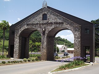
Antônio Prado is a municipality located in the Serra Gaúcha regionin The city is in the state of Rio Grande do Sul, Brazil. It boasts the largest collection of architectural heritage designated by IPHAN related to Italian colonization in Brazil. Its population is estimated at 13,045 people.

Cambará do Sul is a municipality in the state of Rio Grande do Sul, Brazil. Its population was approximately 6,406 in 2020. It has an area of approximately 1212 km2.

Jaquirana is a municipality in the state of Rio Grande do Sul, Brazil. As of 2020, the estimated population was 3,662.

Poço das Antas is a municipality in the state of Rio Grande do Sul, Brazil.

Veranópolis is a municipality in the state of Rio Grande do Sul, Brazil. As of 2020, the estimated population was 26,533.
The Da Prata River is a river of Rio Grande do Sul state in southern Brazil. It is a tributary of the Das Antas River.

The Das Antas River is a river of Rio Grande do Sul state in southern Brazil. Below its junction with the Carreiro it forms the Taquari River.
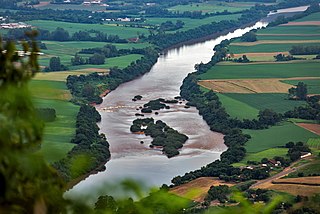
The Taquari River is a river of Rio Grande do Sul state in southern Brazil. It is a left tributary of the Jacuí River, into which it flows at Triunfo. In its upper course, it is called Rio das Antas.

Caçador is a municipality in the state of Santa Catarina in the South region of Brazil.

The São Francisco de Paula National Forest is a national forest in the state of Rio Grande do Sul, Brazil.

The Tainhas State Park is a state park in the state of Rio Grande do Sul, Brazil. It protects forests in the valley of the Tainhas River surrounded by open fields. The main attraction is the Cachoeira do Passo do S, a waterfall.
The Lajeado Grande River is a river in the state of Rio Grande do Sul, Brazil. The river empties into the Das Antas River, the upper reaches of the Taquari River.
The Leão River is a river of Rio Grande do Sul state in southern Brazil. The Leão River flows from Ipê, passes through Antônio Prado, and empties into the Das Antas River.

