
Sekani or Tse’khene are a First Nations people of the Athabaskan-speaking ethnolinguistic group in the Northern Interior of British Columbia. Their territory includes the Finlay and Parsnip River drainages of the Rocky Mountain Trench. The neighbours of the Sekani are the Babine to the west, Dakelh to the south, Dunneza (Beaver) to the east, and Kaska and Tahltan, to the north, all Athabaskan peoples. In addition, due to the westward spread of the Plains Cree in recent centuries, their neighbours to the east now include Cree communities.
The Stuart River or Nak'alkoh is one of the largest tributaries of the Nechako River in northeastern British Columbia, Canada. The Nechako is in turn one the more important tributaries of the Fraser River. The Stuart River flows 187 kilometres (116 mi) from Stuart Lake to its junction with the Nechako River. The river drains a portion of the Nechako Plateau—a gently-rolling region characterized by small lakes and tributaries. Low but impressive ridges interact with the river, creating high bluffs and hoodoos.
Takla Lake Marine Provincial Park is a provincial park in British Columbia, Canada. Located northeast of the town of Smithers and roughly parallel to Babine Lake to its west/southwest, it comprises three sites on Takla Lake in the northwestern part of the Omineca Country of the province's North-Central Interior. The three sites are the Sandy Point Site, containing about 160 ha, Takla Lake West containing about 41 ha, and White Bluff, containing about 349 ha.
The Skeena Mountains, also known as the Skeenas, are a subrange of the Interior Mountains of northern British Columbia, Canada, essentially flanking the upper basin of the Skeena River. They lie just inland from the southern end of the Boundary Ranges of the Coast Mountains, and also of the northern end of the Kitimat Ranges. Their southern limit is described by the Bulkley River and the upper northwestern reaches of Babine and Takla Lakes, and on their northeast by the upper reaches of the Omineca River.
Soda Creek is a rural subdivision 38 km north of Williams Lake in British Columbia, Canada. Located on the east bank of the Fraser River, Soda Creek was originally the home of the Xat'sull First Nation. Soda Creek Indian Reserve No. 1 is located on the left (E) bank of the Fraser River, one mile south of the Soda Creek BCR (CN) station, 431.10 ha. 52°19′00″N122°16′00″W
The Whispering Pines/Clinton Indian Band, also called the Pellt'iq't First Nation is a member of the Secwepemc (Shuswap) Nation, located in the Central Interior region of the Canadian province of British Columbia. Its main Indian reserve is located at Clinton, British Columbia. It was created when the government of the then-Colony of British Columbia established an Indian reserve system in the 1860s. It is a member government of the Shuswap Nation Tribal Council.
The Williams Lake First Nation is a First Nations government of the Secwepemc (Shuswap) Nation, located in the Cariboo region of the Central Interior region of the Canadian province of British Columbia, at the city of Williams Lake. It was created when the government of the then-Colony of British Columbia established an Indian reserve system in the 1860s. It is a member government of the Northern Shuswap Tribal Council. Its main Indian Reserve is Williams Lake Indian Reserve No. 1, a.k.a. "Sugarcane" or "The Cane" or "SCB".

The Stswecem'c Xgat'tem First Nation, formerly known as Canoe Creek Band/Dog Creek Indian Band, created as a result of merger of the Canoe Creek Band and Dog Creek Band is a First Nations government of the Secwepemc (Shuswap) Nation, located in the Fraser Canyon-Cariboo region of the Central Interior of the Canadian province of British Columbia. It was created when the government of the then-Colony of British Columbia established an Indian reserve system in the 1860s. It is a member government of the Northern Shuswap Tribal Council.
The High Bar First Nation is a First Nations government of the Secwepemc (Shuswap) Nation, located in the Fraser Canyon-Cariboo region of the Central Interior of the Canadian province of British Columbia. It was created when the government of the then-Colony of British Columbia established an Indian reserve system in the 1860s. It is one of three Secwepemc bands that is not a member of either the Shuswap Nation Tribal Council or the Northern Shuswap Tribal Council. The High Bar people are also partly Tsilhqot'in and have links with some Chilcotin First Nations.
The Kluskus First Nation is the band government of the Lhoosk’uz, a Dakelh people whose main reserve located on the Chilcotin Plateau 130 km west of the city of Quesnel, British Columbia, Canada. The First Nation is a member of the Carrier-Chilcotin Tribal Council, which includes both Tsilhqot'in and Carrier (Dakelh) communities.
The Red Bluff First Nation is a Dakelh First Nations government located in the northern Fraser Canyon region of the Canadian province of British Columbia. It is a member of the Carrier-Chilcotin Tribal Council, which includes both Tsilhqot'in and Carrier (Dakelh) communities.
The Tlʼesqox First Nation is a Tsilhqotʼin community located west of the Fraser Canyon in the Chilcotin region of the Canadian province of British Columbia. It is a member of the Carrier-Chilcotin Tribal Council, which includes both Tsilhqotʼin and Carrier (Dakelh) communities.
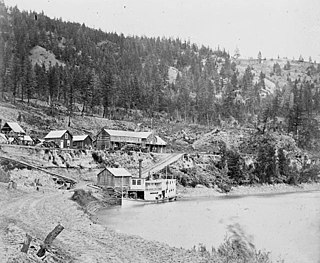
The Enterprise was a passenger and freight sternwheeler that was built for service on the Soda Creek to Quesnel route on the upper Fraser River in British Columbia. It was built at Four Mile Creek near Alexandria by pioneer shipbuilder James Trahey of Victoria for Gustavus Blin Wright and Captain Thomas Wright and was put into service in the spring of 1863. Her captain was JW Doane. The Enterprise was the first of twelve sternwheelers that would work on this section of the Fraser from 1863 to 1921. Though she was not large, she was a wonderful example of the early craft of shipbuilding. All of the lumber she was built from was cut by hand and her boiler and engines had been brought to the building site at Four Mile packed by mule via the wagon road from Port Douglas, 300 miles away.

Frank Cyril Swannell was one of British Columbia's most famous surveyors.
The Nazko First Nation is a First Nations government of the Dakelh people in the north-central Interior of British Columbia. Its reserves are located around the community of Nazko, British Columbia, which is 120 km west of Quesnel and southwest of Prince George.
The Middle River, or in the Carrier language (Dakelh) Dzitl'ainli Koh, is a river in the Omineca Country of the northwestern Central Interior of British Columbia, Canada, flowing southeast from the outlet of Takla Lake into Trembleur Lake over a distance of approximately 35 kilometres (22 mi). The river is part of the route of the Stuart River-Takla Lake salmon run, which comes up the Fraser River via its tributaries the Nechako and Stuart Rivers and terminates at Takla Lake, and the route of the unfinished Dease Lake Extension of the British Columbia Railway runs along the river's left (north) bank. The community of Middle River, including the Dzitline Lee Indian Reserve 9. O K'Ay Wha Cho 26, another Indian reserve, is located on the west bank of the river between Takla and Trembleur Lakes.
The Tlowitsis Nation, formerly the Klowitsis Tribe, the Turnour Island Band and the Tlowitsis-Mumtagila First Nation, is the Indian Act band government of the Ławit'sis (Tlowitsis) tribe of the Kwakwaka'wakw peoples, located in the Queen Charlotte Strait-Johnstone Strait area in the Discovery Islands between Vancouver Island and the British Columbia mainland in Canada. Ławit'sis territory covers parts of northern Vancouver Island, Johnstone Strait, and adjoining inlets of the mainland. Kalugwis, on Turnour Island, was their principal community in times past, but the band's offices are in the city of Campbell River to the southeast. Hanatsa IR No. 6 on Port Neville is the most populated of the band's Indian reserves.
The Tsay Keh Dene First Nation is one of the Sekani bands of the Northern Interior of British Columbia. The territories, settlements, and reserves surround Williston Lake in the Omineca region of central British Columbia. The locations range from about 155 kilometres (96 mi) north of Prince George to 495 kilometres (308 mi) northwest of the city.

Port Neville is a bay, port and locality on the north side of Johnstone Strait, south of Call Inlet, in the Central Coast region of British Columbia, Canada.
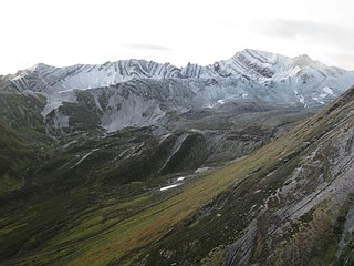
Omineca Provincial Park and Protected Area is a provincial park and protected area located in the north-central interior of British Columbia, Canada. It was established on 11 April 2001 by BC Parks to protect provincially significant riparian and wetland habitats along the Omineca River.
