
Dew is water in the form of droplets that appears on thin, exposed objects in the morning or evening due to condensation.

Mount Hermon is a mountain cluster constituting the southern end of the Anti-Lebanon mountain range. Its summit straddles the border between Syria and Lebanon and, at 2,814 m (9,232 ft) above sea level, is the highest point in Syria. On the top, in the United Nations buffer zone between Syrian and Israeli-occupied territories, is the highest permanently manned UN position in the world, known as "Hermon Hotel", located at 2814 metres altitude. The southern slopes of Mount Hermon extend to the Israeli-occupied portion of the Golan Heights, where the Mount Hermon ski resort is located with a top elevation of 2,040 m (6,690 ft). A peak in this area rising to 2,236 m (7,336 ft) is the highest elevation in Israeli-controlled territory.

The Southern District is one of Israel's six administrative districts, the largest in terms of land area but the most sparsely populated. It covers most of the Negev desert, as well as the Arava valley. The population of the Southern District is 1,086,240 and its area is 14,185 km2. Its population is 79.66% Jewish and 12.72% Arab, with 7.62% of other origins.
Ganei Tal was an Israeli settlement in the south of the Gaza Strip, located in the Gush Katif settlement bloc. It was under the jurisdiction of Hof Aza Regional Council.

There are six main administrative districts of Israel, known in Hebrew as mekhozot and Arabic as mintaqah and fifteen sub-districts known as nafot. Each sub-district is further divided into natural regions, which in turn are further divided into council-level divisions: whether they might be cities, municipalities, or regional councils.
Regional councils are one of the three types of Israel's local government entities, with the other two being cities and local councils. As of 2019, there were 54 regional councils, usually responsible for governing a number of settlements spread across rural areas. Regional councils include representation of anywhere between 3 and 54 communities, usually spread over a relatively large area within geographical vicinity of each other.

Stuart Dew is an Australian rules football coach and former head coach of the Gold Coast Suns in the Australian Football League (AFL). As a player he played for the Port Adelaide Football Club and Hawthorn Football Club in the Australian Football League. Dew was acknowledged as being a long penetrating left foot kick of the football.

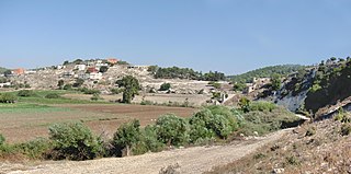
Tal Menashe is an Israeli outpost in the West Bank, retroactively legalized under Israeli law as an extension (suburb) of the Israeli settlement of Hinanit, located in the Samarian hills on the northwestern edge of the West Bank. The outpost, under the administrative municipal government of the Shomron Regional Council, is adjacent to Hinanit and Shaked. It was founded in 1992 as an Israeli outpost next to the settlement of Hinanit, and moved to it final land at 1999 on state lands nearby. It was founded by a group of Israelis from a kollel in Mevaseret Zion and from the Technion in Haifa.

Avital is a moshav in northern Israel. Located ten kilometers south of Afula, it falls under the jurisdiction of Gilboa Regional Council. In 2021 its population was 489.

Al-Batuf Regional Council is a regional council located on the southern fringe of the Beit Netofa Valley North of Nazareth within the Northern District of Israel. It was formerly part Nof HaGalil regional council until 2000 and consists of the following four rural Israeli Palestinian Arab villages.
Tlalim is a kibbutz in southern Israel. Located in the Negev desert, it falls under the jurisdiction of Ramat HaNegev Regional Council. In 2021 it had a population of 591.

Megadim is a moshav in northern Israel. Located on the Mediterranean coast near Atlit and Highway 4, about 12 kilometres south of Haifa, it falls under the jurisdiction of Hof HaCarmel Regional Council. In 2021 it had a population of 1,388.
Orot is a moshav in south Israel. Located near Kiryat Malakhi and covering an area of 2,000 dunams, it falls under the jurisdiction of Be'er Tuvia Regional Council. In 2021 it had a population of 472.

Ein Ya'akov is a moshav in northern Israel. Located near Ma'alot-Tarshiha, it falls under the jurisdiction of Ma'ale Yosef Regional Council. In 2021 it had a population of 1,215.

Tal Shahar is a moshav in central Israel. Located between Gedera and Latrun, it falls under the jurisdiction of Mateh Yehuda Regional Council. In 2021, it had a population of 1,375.
The Palestine League, also known as The Eretz Israel League, was an association football league during the British Mandate of Palestine, which was contested from 1928 to 1948. It was organised by the Eretz Israel Football Association, and is therefore regarded as the original incarnation of the modern Israeli top flight league, which has existed since 1948.

Hurshat Tal is a national park and nature reserve in the Northern District of Israel. In 1968, 765 dunams were declared national park lands and 107 dunams were declared a nature reserve.

Ganei Tal is a moshav in central Israel. Located to the south of Gedera, it falls under the jurisdiction of Nahal Sorek Regional Council. In 2021 it had a population of 909.
Ras Ali is an Arab village in northern Israel. Located to the south of Shefa-'Amr, it falls under the jurisdiction of Zevulun Regional Council. In 2021 it had a population of 656.

