Tambo (Inca structure)

Last updated

A tambo (Quechua: tampu, "inn") was an Inca structure built for administrative and military purposes. Found along the extensive roads, tambos typically contained supplies, served as lodging for itinerant state personnel, [1] and were depositories of quipu-based accounting records. Individuals from nearby communities within the Inca empire were conscripted to maintain and serve in the tambos, as part of the mit'a labor system. [2] Tambos were spaced along Inca roads, generally about one day's travel apart.

Contents

Characteristics and functions

The Incas built many of their tambos when they began to upgrade their empire-wide road system during the reign of Thupa Inka Yupanki from 1471 to 1493. [3] Scholars estimate there were 2,000 or more tambos. [3] Given this amount, the sheer variety of tambo size and function are hard to fully describe. [2] At a minimum, tambos would contain housing, cooking facilities, and storage silos called qullqas. [4] Beyond this, a considerable amount of variation between different tambos exists. Some tambos were little more than simple inns, while others were essentially cities that provided temporary housing for travelers. [4] Further, there are no clear markers that distinguish larger tambos from villages or small administrative centers. [5] Architecture and documentary evidence suggest that the functional sizes of the settlements probably corresponded to their capacity to house a population. [6]

Qunchamarka tambo on Inca Trail to Machu Picchu Conchamarka (cooking stove spot).jpg
Qunchamarka tambo on Inca Trail to Machu Picchu

The functions of the tambos were dependent on their size as well as the facilities they contained. [2] Every tambo had the capacity to house various state officials. [4] For example, the smallest tambos served as relay stations for the chasquis, who were state messengers who ran along state roads. [4] [7] Larger tambos could provide other functions as well. For example, larger tambos would have larger storehouses that could provide supplies and some lodging for armies on the move. [8] This function should not be allowed to cause confusion between tambos and qullqa, which were only storehouses that armies would resupply from as they passed by. [9] The largest and most luxurious tambos were generally used to lodge the traveling Inca and his entourage (typically wives and state officials). [4] [7]

Beyond taking care of various kinds of travelers, larger tambos would also contain facilities where various specialists, such as potters and weavers, would produce their goods. [4] They could also serve as administrative centers from which local lords would oversee the region. [8] Furthermore, larger tambos would contain ceremonial spaces which would serve as places for religious practices. [8] Additionally, historians have also found evidence of hunting activity, mining activity, and coca production/exploitation at tambo sites. [10]

Pedro Cieza de León made numerous references to the tambos in his Crónicas de Peru; in the following passage, Cieza de León described the general uses for the tambos that he learned from native peoples:

And so there would be adequate supplies for their men, every four leagues there were lodgings and storehouses, and the representatives or stewards who lived in the capital of the provinces took great care to see that the natives kept these inns or lodgings (tambos) well supplied. And so certain of them would not give more than others, and all should make their contribution, they kept the accounts by a method of knots, which they call quipus, and in this way, after the troops had passed by, they could check and see that there had been no fraud. [11]

Spacing

Many historians or scholars state that tambos are generally placed a day's walk from each other. [12] However, as Hyslop points out, there are many factors, both individual and external, that can affect how much one can walk in a day, making this unreliable as a measure of physical distance. [12] In practice, the distances between tambos vary wildly, ranging from fewer than 10 km to nearly 45 km. [13] Many different factors affected the placement of these tambos. In general, the Inca would try to build them near water and favorable terrain, while they would try to avoid unfavorable terrain (such as marshes or steep slopes). [14] In some cases, the Inca would try to build away from local population centers (for reasons unknown), but other times would try to build near local labor sources. [15] Furthermore, tambos placement may have been influenced by the average speed of llama caravans, which would move more slowly than an individual. [15] Another important traveler that would move more slowly than a typical individual would be the Sapa Inka. [16] Since the Sapa Inka would travel with a grand procession, travel would be slower than if he were traveling alone, which would require closer tambo placement. [16]

Architecture

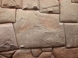
Remains of tambos are scattered throughout modern-day Peru, Bolivia, Chile, and Colombia. [17] The remains of the tambos display a large variety of architectural styles. Although this variation is hard to capture in complete detail, some rough categories can be defined. For example, some tambos were built before the Inca empire existed, and the Inca simply took control of them. [18] Pre-Inca tambo architecture can be divided into 2 basic categories. Some tambos were not modified in any way and therefore feature an architectural style that is distinctly pre-Inca. [18] However, some of these sites were renovated by the Inca, so some pre-Inca sites do feature some Inca architecture. [18]

For the sites built in the Inca period, the architecture styles can be divided into three basic categories. Some tampu were definitively local in their architectural style. [18] This typically happened in places where the local culture was strong and was permitted to continue. [18] Other sites would have mostly Inca architecture, but would have at least some subtle influence from local traditions. [19] Finally, some tambos would contain only Inca style architecture. [20] Because of the strong influence local culture tends to have on these structures, Inca style-only tambos tend to exist more in isolated areas as opposed to areas with large populations. [20]

The kancha was an architectural feature found in many tambos throughout the Inca empire. [21] The kancha consists of a walled rectangular enclosure , which houses a number of smaller one-room structures, facing a courtyard. [21] The decision to build smaller structures within appears to be related to the "cold, rainy environment of the Andean highlands." [21] Hyslop notes that the kancha was the most common Inca structure, ranging from the great Qorikancha in Cusco to the smallest, remotest tambo along the Inca roads system. [21] Thus, kanchas were not only present in tambos, but were present in a variety of Inca buildings. [21] Historians think that kanchas were typically used as living facilities, which reflects the tambos purpose of housing traveling individuals or groups. [21]

Tambos after the Inca collapse

Scholars such as Craig Morris note that, after the collapse of the Inca empire, the people living within the territory of the former empire ceased to use tambos as they had before. [22] From this, Morris suggests that the tambo system was a part of an "artificial urbanism" created by the Inca empire. [3] Thus, tambos had been less useful to the people living throughout the Inca empire than they were to the Incas themselves. [3] Morris supports this argument with statements that tambos were frequently positioned for interregional contact and travel, as opposed to being positioned near large local villages. [3]

Although indigenous Andeans may have stopped using tambos after the fall of the Inca empire, tambos did not go entirely out of use: Spanish colonizers began to make use of the tambo system. [23] Sometimes the Spaniards used the original Inca tambo structures, but the Spaniards also built new structures along roads. [23] Sometimes the Spaniards would build a new tambo along a road that still had a leftover tambo from the Inca empire. [23] Historians know that the Spanish extended the tambo system beyond what existed throughout the Inca empire, increasing the amount of territory covered. [23]

The city of Santiago was built around an indigenous settlement with an irrigation system and a "Tambo Grande". According to archaeologist Rubén Stehberg the Spanish utilized pre-existing buildings and did not built any structure in Santiago until no less than eight months after their arrival to the location. [24]

See also

Related Research Articles

<span class="mw-page-title-main">Inca Empire</span> 1438–1533 empire in South America

The Inca Empire, called Tawantinsuyu by its subjects, was the largest empire in pre-Columbian America. The administrative, political, and military center of the empire was in the city of Cusco. The Inca civilization rose from the Peruvian highlands sometime in the early 13th century. The Spanish began the conquest of the Inca Empire in 1532 and by 1572, the last Inca state was fully conquered.

<span class="mw-page-title-main">Inca road system</span> Transportation system of the Inca empire

The Inca road system was the most extensive and advanced transportation system in pre-Columbian South America. It was about 40,000 kilometres (25,000 mi) long. The construction of the roads required a large expenditure of time and effort.

<span class="mw-page-title-main">Chachapoya culture</span> Andean culture

The Chachapoyas, also called the "Warriors of the Clouds", was a culture of the Andes living in the cloud forests of the southern part of the Department of Amazonas of present-day Peru. The Inca Empire conquered their civilization shortly before the Spanish conquest in the 16th century. At the time of the arrival of the conquistadors, the Chachapoyas were one of the many nations ruled by the Incas, although their incorporation had been difficult due to their constant resistance to Inca troops.

<span class="mw-page-title-main">Ollantaytambo</span> Archaeological site in Peru

Ollantaytambo is a town and an Inca archaeological site in southern Peru some 72 km (45 mi) by road northwest of the city of Cusco. It is located at an altitude of 2,792 m (9,160 ft) above sea level in the district of Ollantaytambo, province of Urubamba, Cusco region. During the Inca Empire, Ollantaytambo was the royal estate of Emperor Pachacuti, who conquered the region, and built the town and a ceremonial center. At the time of the Spanish conquest of Peru, it served as a stronghold for Manco Inca Yupanqui, leader of the Inca resistance. Located in the Sacred Valley of the Incas, it is now an important tourist attraction on account of its Inca ruins and its location en route to one of the most common starting points for the four-day, three-night hike known as the Inca Trail.

<i>Chasqui</i> Inca messengers

A chasqui was a messenger of the Inca empire. Agile, highly trained and physically fit, they were in charge of carrying messages –in the form of quipus or oral information– and small packets. Along the Inca road system there were relay stations called chaskiwasi, placed at about 2.5 kilometres (1.6 mi) from each other, where the chasqui switched, exchanging their message(s) with the fresh messenger. The chasqui system could be able to deliver a message or a gift along a distance of up to 300 kilometres (190 mi) per day.

<span class="mw-page-title-main">Inca architecture</span> Pre-Columbian architecture in South America

Inca architecture is the most significant pre-Columbian architecture in South America. The Incas inherited an architectural legacy from Tiwanaku, founded in the 2nd century B.C.E. in present-day Bolivia. A core characteristic of the architectural style was to use the topography and existing materials of the land as part of the design. The capital of the Inca empire, Cuzco, still contains many fine examples of Inca architecture, although many walls of Inca masonry have been incorporated into Spanish Colonial structures. The famous royal estate of Machu Picchu is a surviving example of Inca architecture. Other significant sites include Sacsayhuamán and Ollantaytambo. The Incas also developed an extensive road system spanning most of the western length of the continent and placed their distinctive architecture along the way, thereby visually asserting their imperial rule along the frontier.

<span class="mw-page-title-main">Coricancha</span> Archaeological site in Peru

Coricancha, Curicancha, Koricancha, Qoricancha or Qorikancha was the most important temple in the Inca Empire, and was described by early Spanish colonialists. It is located in Cusco, Peru, which was the capital of the empire.

<span class="mw-page-title-main">Inca technology</span> Devices, and technologies invented or used in the Inca civilisation

Inca technology includes devices, technologies and construction methods used by the Inca people of western South America, including the methods Inca engineers used to construct the cities and road network of the Inca Empire.

<span class="mw-page-title-main">Inti</span> Incan sun god

Inti is the ancient Inca sun god. He is revered as the national patron of the Inca state. Although most consider Inti the sun god, he is more appropriately viewed as a cluster of solar aspects, since the Inca divided his identity according to the stages of the sun. Worshiped as a patron deity of the Inca Empire, Pachacuti is often linked to the origin and expansion of the Inca Sun Cult. The most common belief was that Inti was born of Viracocha, who had many titles, chief among them being the God of Creation.

<span class="mw-page-title-main">Inca army</span>

The Inca army was the multi-ethnic armed forces used by the Tawantin Suyu to expand its empire and defend the sovereignty of the Sapa Inca in its territory.

<span class="mw-page-title-main">Raqch'i</span> Archaeological site in Peru

Raqch'i (Quechua) is an Inca archaeological site in Peru located in the Cusco Region, Canchis Province, San Pedro District, near the populated place Raqch'i. It is 3480 meters above sea level and 110 kilometers from the city of Cuzco. It also known as the Temple of Wiracocha, one of its constituents. Both lie along the Vilcanota River. The site has experienced a recent increase in tourism in recent years, with 83,334 visitors to the site in 2006, up from 8,183 in 2000 and 452 in 1996.

The Inca aqueducts refer to any of a series of aqueducts built by the Inca people. The Inca built such structures to increase arable land and provide drinking water and baths to the population. Due to water scarcity in the Andean region, advanced water management was necessary for the Inca to thrive and expand along much of the coast of Peru. Such structures, some of which survive today, show the advanced hydraulic and civil engineering capabilities of the Inca.

<span class="mw-page-title-main">Huchuy Qosqo</span> Archaeological site in Peru

Huchuy Qosqo,, is an Incan archaeological site north of Cuzco, Peru. Its name is Quechua for "Little Cuzco." It lies at an elevation of 3,650 meters, overlooking the Sacred Valley and 3 kilometres (1.9 mi) west and above the town of Lamay at an elevation of 2,920 metres (9,580 ft). The site received its name in the 20th century; previously it had been known as Caquia Xaquixaguana, or Kakya Qawani.

<span class="mw-page-title-main">Ushnu</span>

In the Inca Empire the ushnu was an altar for cults to the deities, a throne for the Sapa Inca (emperor), an elevated place for judgment and a reviewing stand of military command. In several cases the ushnu may have been used as a solar observatory. Ushnus mark the center of plazas of the Inca administrative centers all along the highland path of the Inca road system.

<span class="mw-page-title-main">Qullqa</span> Inca storage building

A qullqa (Quechua pronunciation:[ˈqʊʎˌqa] "deposit, storehouse"; was a storage building found along roads and near the cities and political centers of the Inca Empire. These were large stone buildings with roofs thatched with "ichu" grass, or what is known as Peruvian feathergrass. To a "prodigious [extent] unprecedented in the annals of world prehistory" the Incas stored food and other commodities which could be distributed to their armies, officials, conscripted laborers, and, in times of need, to the populace. The uncertainty of agriculture at the high altitudes which comprised most of the Inca Empire was among the factors which probably stimulated the construction of large numbers of qullqas.

<span class="mw-page-title-main">Andean civilizations</span> Civilizations of South Americas Andes Mountains

The Andean civilizations were South American complex societies of many indigenous people. They stretched down the spine of the Andes for 4,000 km (2,500 mi) from southern Colombia, to Ecuador and Peru, including the deserts of coastal Peru, to north Chile and northwest Argentina. Archaeologists believe that Andean civilizations first developed on the narrow coastal plain of the Pacific Ocean. The Caral or Norte Chico civilization of coastal Peru is the oldest known civilization in the Americas, dating back to 3500 BCE. Andean civilization is one of the six "pristine" civilizations of the world, created independently and without influence by other civilizations.

<span class="mw-page-title-main">Band of Holes</span> Archaeological site in Peru

The Band of Holes, also known in Spanish as Monte Sierpe or Cerro Viruela, is a series of about 5,000–6,000 man-sized holes found in the Pisco Valley on the Nazca Plateau in Peru. Local people have no idea who made them or how they were used. Over the years, it has been speculated that they were graves, defensive positions, or storage places. Recent thought is that they were storage pits built during the time of the Inca Empire (1438–1533).

<span class="mw-page-title-main">Huánuco Pampa</span> Archaeological site in Peru

Huánuco Pampa, Huánuco Marka or Huánuco Viejo, Wanako Pampa, Wanuku Pampa or simply Huánuco is a large archaeological site in Peru in the Huánuco Region, Dos de Mayo Province, La Unión District. The ruins of the city lie on a plateau above the Urqumayu or Vizcarra River in the central Andes. The Incas administered their large empire through a small number of administrative centers, such as Huánuco Pampa. The administrative centers were linked by the extensive Inca road system. The most important of the roads, the Qhapaq Ñan, which ran from Cusco to Quito, passed through Huánuco Pampa. The Inca authorities in Huánuco ruled at least five, and perhaps more, ethnic groups. The city is situated on an important commercial trade route and sits on top of a plateau with ravines on all sides in order to allow easy defense of the city. During the Spanish conquest of the Incas, Huánuco Pampa was briefly occupied by Gomez de Alvarado, who founded a Spanish city but it was quickly moved to Pillco because of the harsh climate of Huánuco and the raids of Illa Tupac, one of the captains of Manco Inca.

<span class="mw-page-title-main">Economy of the Inca Empire</span>

The economy of the Inca Empire was based on local traditions of solidarity and mutualism, transported to an imperial scale. It was based on the institution of reciprocity, considered the socioeconomic and political system of the Pre-Columbian Andes.

<span class="mw-page-title-main">Inca kancha</span> Inca walled enclosure composed of buildings that face onto a courtyard

A kancha is an Inca rectangular or trapezoidal walled enclosure composed of single-room buildings that face onto a common open courtyard or inner patio in the middle of the enclosure. Kanchas are widespread in the Inca Empire and normally have only one entrance gate. An Inca kancha includes constructions intended for a single function: housing, temples, palaces. In Cusco, the capital of the Empire there existed many kanchas, among them the Coricancha, the Sun temple, the Hatunkancha that housed aqllawasi the house of the acclas and Amarukancha, the large hall facing the main square called Huakaypata. Other notable kanchas are found in Ollantaytambo and Patallaqta.

References

  1. Provincial Power in the Inka Empire. by Terence N. D'Altroy. 1992. Smithsonian Institution. page 101 ISBN   1-56098-115-6
  2. 1 2 3 Hyslop, John (1984). The Inka Road System. Orlando, Florida: Academic Press, Inc. p. 275.
  3. 1 2 3 4 5 D’Altroy, Terence N. The Incas. Blackwell Publishing, 2003, pg. 238.
  4. 1 2 3 4 5 6 Suarez and George. (2011) Pg. 40
  5. Hyslop, John (1984). The Inka Road System. Orlando, Florida: Academic Press, Inc. p. 278.
  6. Provincial Power in the Inka Empire. by Terence N. D'Altroy. 1992. Smithsonian Institution. page 98. ISBN   1-56098-115-6
  7. 1 2 The Wired Professor (2008). "A History of Information Highways and Byways". Archived from the original on 2008-01-16. Retrieved 2008-01-24.
  8. 1 2 3 Hyslop, John. The Inka Road System. Academic Press, 1984. Pg. 279.
  9. Suarez, Ananda Cohen, and Jeremy James George. Handbook to Life in the Inca World. Facts On File, 2011. Pg. 110
  10. Hyslop, John (1984). The Inka Road System. Orlando, Florida: Academic Press, Inc. p. 279.
  11. Cieza de León, Pedro de, The Incas of Pedro de Cieza de León, translated by Harriet de Onis. Norman, OK: University of Oklahoma Press, 1959, p. 105 (Chapter LXXXII).
  12. 1 2 Hyslop. (1984). Pg. 297.
  13. Hyslop. (1984). Pg. 300.
  14. Hyslop. (1984). Pg. 301.
  15. 1 2 Hyslop. (1984). Pg. 301-302.
  16. 1 2 Hyslop. (1984). Pg. 303.
  17. Owen, Bruce (2006). "The Inka: The Lens Through Which We See the Andean Past" (PDF). Retrieved 2008-01-24.
  18. 1 2 3 4 5 Hyslop. (1984) Pg. 280
  19. Hyslop. (1984). Pg 280-281.
  20. 1 2 Hyslop. (1984). Pg. 281.
  21. 1 2 3 4 5 6 Hyslop, John (1984). The Inka Road System. Orlando, Florida: Academic Press, Inc. p. 282.
  22. D'Altroy, Terence (2003). The Incas. Malden, MA: Blackwell. p. 238.
  23. 1 2 3 4 Hyslop, John (1984). The Inka Road System. Orlando, Florida: Academic Press, Inc. p. 276.
  24. "Valdivia no fundó Santiago". 24horas.cl. 2013-01-22. Retrieved 2021-03-03.

Further reading