Udayapur is a Village Development Committee in Banke District in the Bheri Zone of south-western Nepal. At the time of the 1991 Nepal census it had a population of 2,301 and had 397 houses in the village. Two government owned primary schools are situated here along with one among 10 Health Posts in district and a Police station. Now, it is a part of Nepalgunj sub-metropolitan city.

Baraha, Sagarmatha is a village development committee in Udayapur District in the Sagarmatha Zone of south-eastern Nepal. At the time of the 1991 Nepal census it had a population of 2738 people living in 471 individual households.
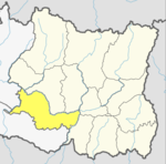
Bărăi is a village development committee in Udayapur District in the Sagarmatha Zone of south-eastern Nepal. At the time of the 1991 Nepal census it had a population of 4613.
Basaha is a town in Beltar Basaha Municipality in Udayapur District in the Sagarmatha Zone of south-eastern Nepal. The formerly village development committee was merged to form a new municipality on 18 May 2014. At the time of the 1991 Nepal census it had a population of 7887 people living in 1464 individual households.

Jalpachilaune is a populated place located in Triyuga municipality of Udayapur District in Province No. 1 of Nepal. At the time of 2011 Nepal census it had a population of 3,864 people living in 807 individual households.
Janti is a village development committee in Udayapur District in the Sagarmatha Zone of south-eastern Nepal. At the time of the 1991 Nepal census it had a population of 2142 people living in 385 individual households.
Jogidaha is a populated place located in Triyuga municipality of Udayapur District in Province No. 1 of Nepal. At the time of 2011 Nepal census it had a population of 6,665 people living in 1,451 individual households.
Katari is a Municipality in Udayapur District in the Province No. 1 of south-eastern Nepal.It lies by the Tawa river having the bridge of length 123.5m. This was established by merging two existing village development committees i.e. Triveni and Katari on 18 May 2014. At the time of the 1991 Nepal census it had a population of 7230 people living in 1410 individual households.
Khanbu is a populated place located in Triyuga municipality of Udayapur District in Province No. 1 of Nepal. At the time of 2011 Nepal census it had a population of 4,350 people living in 782 individual households.
Laphagaun was a village development committee in Udayapur District in the Sagarmatha Zone of Eastern Development Region of Nepal. It became part of Rautamai Rural Municipality after reconstruction of administration in Nepal.
Panchawati is a village in, and headquarter of, Udayapurgadhi rural municipality in Udayapur District in Province No. 1 of south-eastern Nepal. At the time of the 1991 Nepal census it had a population of 6,580 people living in 1223 individual households.
Valaya Danda is a village development committee in Udayapur District in the Sagarmatha Zone of south-eastern Nepal. At the time of the 1991 Nepal census it had a population of 5770 people living in 1021 individual households.
Sithdipur is a village development committee in Udayapur District in the Sagarmatha Zone of south-eastern Nepal. At the time of the 1991 Nepal census it had a population of 2606 people living in 459 individual households.
Tawasri is a village development committee in Udayapur District in the Sagarmatha Zone of south-eastern Nepal. At the time of the 1991 Nepal census it had a population of 4612 people living in 843 individual households.
Thanagaun is a village development committee in Udayapur District in the Sagarmatha Zone of south-eastern Nepal. At the time of the 1991 Nepal census it had a population of 2408 people living in 428 individual households.
Triveni is a town in Katari Municipality in Udayapur District in the Sagarmatha Zone of south-eastern Nepal. The formerly Triveni village development committee was merged to form new municipality from 18 May 2014. At the time of the 1991 Nepal census it had a population of 6015 people living in 1105 individual households.
Udayapur Dhurmi is a village development committee in Parsa District in the Narayani Zone of southern Nepal. At the time of the 2011 Nepal census it had a population of 7,163 people living in 1,085 individual households.
Udayapur is a village development committee in Kapilvastu District in the Lumbini Zone of southern Nepal. At the time of the 1991 Nepal census it had a population of 2814 people living in 478 individual households.
Balamta is a small Village Development Committee in eastern Nepal, located at northern part of the Udayapur District. It is an area with a length of about 30 miles and breadth of 15 miles extending from the top of the foothill down to the Sun Kosi river, one of the major rivers in Nepal, at its eastern tip. Balamta is surrounded by other VDCs such as; Tamlichha, Barah, and Jante. It has been divided into nine wards: Chhatang, Dandatol, Chalestemma, Majhagaun, Tharpulung, Deurali, Laku, and Tirla. The population is about 7,000 and the majority of people who live in these villages are Rai. The communities have a unique culture and their own religion. Balamta has three primary schools, a higher secondary school, a primary health center, a post office, and the office of the VDC. Balamta village is well known for the statue of 'Yalambar', the first Kirat King of Nepal. The society is very consistent, hospitable, and live with a good virtue of ethics. People are well educated and the village has a literacy rate of 90 percent. People from this province are scattered all around the world. The main destination countries are India, Hong Kong, UK, Qatar, Saudi Arabia, Kuwait, China, Malaysia, Dubai, USA, and others.

Belaka is a municipality located in Udayapur District of Province No. 1 of Nepal. It is one out of total four urban municipalities located in Udayapur District. It has covered eastmost areas of Udayapur District.