Siddhipur

Last updated
Siddhipur
सिद्धिपुर
Thasi (थसि)
Siddhipur Devnani Ganesh Bhairav Temple.jpg
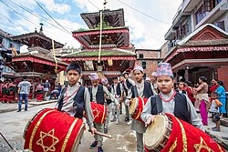
Temple of Lord Ganesh & Lord Bhairav at Devnani, Siddhipur along with Dhaa: Baja of Siddhipur
Coordinates: 27°38′46″N85°21′26″E / 27.6462080°N 85.3572940°E / 27.6462080; 85.3572940 Coordinates: 27°38′46″N85°21′26″E / 27.6462080°N 85.3572940°E / 27.6462080; 85.3572940
CountryFlag of Nepal.svg    Nepal
Province Bagmati Province
District Lalitpur
Municipality Mahalaxmi Municipality
WardWard No. 6
Government
  TypeMunicipality Ward
  Ward ChairpersonDharma Maharjan
  Socialist & Elected Ward Representative Susan Maharjan
Population
 (2011)
  Total4,254
Time zone UTC+5:45 (Nepal Time)

Siddhipur is a village and former Village Development Committee that is now part of Mahalaxmi Municipality in Bagmati Province of central Nepal. At the time of the 2011 Nepal census it had a population of 6147 (Male: 2888; Female: 3259) living in 1484 individual households.

Contents

Siddhipur is a typical Newari community (87.49% of total population) where the spoken language is Newari (85.46% spoke Newari). The main occupation of the people living in this region is agriculture. Most of the people fully depend on the agriculture for their living. Siddhipur is also famous for sukul, which is a kind of handmade mat made of hay, a locally available material.

Location

Siddhipur lies about 7.5 kilometres (4.7 mi) from the national capital of Kathmandu and 5.5 kilometres (3.4 mi) from the district headquarters of Lalitpur. [1]

Education

There are many education institutions in Siddhipur .

SNSchool NameTypeLevelEstablished (in BS)NicknameMottoLogoReference
1Shree Siddhimangal Higher Secondary SchoolPublicHigher Secondary2012Shree Siddhimangal H.S.SN/AN/A[ citation needed ]
2Nepal Don Bosco SchoolPrivateHigher Secondary2001NDBSFor God and For CountryN/A [2]
3 Mount Olive English Secondary School PrivateSecondary2044MOESS"Education is your life, guard it well"N/A[ citation needed ]
4 Kopila English Secondary School PrivateSecondary2046KESSN/AN/A[ citation needed ]
5 Anant English School PrivateSecondary2048AES"From Dark Unto Light"N/A[ citation needed ]
6Nava Kunja Secondary SchoolPrivateSecondary2050NKSN/AN/A[ citation needed ]
7Shree Bhanodaya Primary SchoolPublicPrimary2019BhanodayaNext are we, future of nationN/A[ citation needed ]
8Lalit AcademyPrivateSecondary2053LalitN/AN/A[ citation needed ]

Business/Social Organizations

There are many business or social organizations in Siddhipur.

SNOrganization NameTypeEstablishedNicknameMottoLogoReference
1 Unification of The Youth Social Organizationformed on 2072 B.S and legally registered on 2073 B.SUNITYYouths for social changes.
Logo of UNITY Unification of The Youth (UNITY), Siddhipur, Lalitpur.png
Logo of UNITY
http://unity.org.np

Related Research Articles

<span class="mw-page-title-main">Dhading District</span> District in Bagmati Province, Nepal

Dhading District, a part of Bagmati Province, is one of the seventy-seven districts of Nepal. The district, with Dhading Besi as its district headquarters, covers an area of 1,926 square kilometres (744 sq mi), had a population of 338,658 in 2001 and 336,067 in 2011.

<span class="mw-page-title-main">Kaski District</span> District in Gandaki Province, Nepal

Kaski District, a part of Gandaki Province, is one of the seventy-seven districts of Nepal. The name is disambiguated from Kaskikot, the ancient Kaski Kingdom.

<span class="mw-page-title-main">Lalitpur District, Nepal</span> District in Nepal

Lalitpur District (Nepali: ललितपुर जिल्लाListen , a part of Bagmati Province, is one of the seventy-seven districts of Nepal. The district, with Lalitpur as its district headquarters, covers an area of 396.92 km2 and has a population of 337,785. It is one of the three districts in the Kathmandu Valley, along with Kathmandu and Bhaktapur. Its population was 466,784 in the initial 2011 census tabulation. It is surrounded by Makwanpur, Bhaktapur, Kathmandu and Kavre.

<span class="mw-page-title-main">Manang District, Nepal</span> District in Gandaki Pradesh, Nepal

Manang District (Nepali: मनाङ जिल्लाListen , a part of Gandaki Province, is one of the seventy-seven districts of Nepal. The district, with Chame as its district headquarters, covers an area of 2,246 km2 and had a population of 6,538.

<span class="mw-page-title-main">Bandipur Rural Municipality</span> Place in Gandaki Province, Nepal

Bandipur is a hilltop settlement and a rural municipality in Tanahun District, Gandaki province of Nepal. Bandipur is primarily known for its preserved, old time cultural atmosphere. At the time of the 2011 Nepal census it had a population of total 15,591 people living in 3,750 individual households.

<span class="mw-page-title-main">Lomanthang Rural Municipality</span> Rural municipality in Gandaki Province, Nepal

Lomanthang is a rural municipality in Mustang district in Gandaki Province of western Nepal. It is located at the northern end of the district, bordering the Tibet Autonomous Region of China to the north and Dalome rural municipality of Mustang in the south.

Chhampi is a village development committee in Lalitpur District in the Bagmati Zone of central Nepal. At the time of the 1991 Nepal census, it had a population of 5,162 people living in 928 individual households.

Gimdi is one of former Village Development Committee of Lalitpur, Nepal. The village is around 80 kilometer away from Kathmandu. It lies in Ward No. 7 of Bagmati Rural Municipality, Lalitpur Province No. 3 of central Nepal. According to National Population Census, 2299 people who lived of 461 household in Nepal in 2011. It has touched the border of Mahankal Rural Municipality of Lalitpur and Bagmati Rural Municipality of Makwanpur District.

Gotikhel is a village and former Village Development Committee that is now part of Mahankal Rural Municipality in Province No. 3 of central Nepal. At the time of the 1991 Nepal census it had a population of 1654 living in 323 individual households.

<span class="mw-page-title-main">Khokana</span> Part of lalitpur Metropolitant in Bagmati Zone, Nepal

Khokana is a former Village Development Committee (VDC) which has been merged with the neighbouring VDC's of Bungamati, Chhampi, Dukuchhap, Sainbu and other 38 VDC's to form the Metropolitan City of Lalitpur in Lalitpur District in the Bagmati Zone of central Nepal. At the time of the 1991 Nepal census, Khokana had a population of 4258 living in 699 individual households. According to 2011 Nepal census, Khokana had a population of 4927 living in 1056 individual households.

Lele is a village development committee in Lalitpur District in the Bagmati Zone of central Nepal. At the time of the 1991 Nepal census it had a population of 6928 living in 1245 individual households, but the population has increased greatly since then.

Nallu is a village and former Village Development Committee that is now part of Konjyosom Rural Municipality in Province No. 3 of central Nepal. At the time of the 1991 Nepal census it had a population of 1849 living in 320 individual households. Most of the people here are from Tamang Cast. According to the report taken 96.7% people are Tamang.

Sainbu is a village development committee in Lalitpur District in the Bagmati Zone of central Nepal. At the time of the 1991 Nepal census it had a population of 4612 living in 874 individual households.

Thecho is located about 6 km (3.7 mi) south of the main Lalitpur town in Lalitpur district, Godawari Municipality. According to 2011 Nepal census, Thecho has a population of 10,086 living in 2,352 individual households. The offshoot road near the Satdobato segment of the Ring Road leads to Thecho. This roads ultimately leads to Lele and is referred to as Satdobato-Tika Bhairab Road. This road is also called a "Laxmi Prasad Highway" which leads to Hetauda. Thecho has its own unique culture and festivals which include the balkumari jatra,bramayani jatra,nawadurga jatra and sindur jatra locally known as Sinha jatra

<span class="mw-page-title-main">Letang Municipality</span> Municipality in Koshi Zone, Nepal

Letang, "लेटाङ " is a Municipality in Morang District in the Province No. 1 of south-eastern Nepal. It was formed by merging the existing Village Development Committees of Letang, Jante, Warrangi and Bhogateni. This municipality is situated in Hilly Region as well as Terai Region. Letang is full of natural beauty. Previously it was called Letang Bhogateni but now it's known as Letang.

'Ghusel is a village and former Village Development Committee that is now part of Bagmati Rural Municipality in Bagmati Province of central Nepal. It is located southern part of Kathmandu Valley at similar or less heights. At the time of the 2011 Nepal census it had a population of 1510 in 308 individual households, down from the time of the 1991 Nepal census when it had a population of 1715 in 294 individual households.

<span class="mw-page-title-main">Mahalaxmi, Lalitapur</span> Urban Municipality in Bagmati Province, Nepal

Mahalaxmi is a municipality that lies in the north-eastern part of the Lalitpur district of Nepal. As per the declaration by the government of Nepal in 2015, it was created through the merger of the Village development committees Imadol, Lubhu, Tikathali, Siddhipur and Lamatar. The city derives its name from the Mahalaxmi-Mahabhairav Temple in Lubhu. The city's total area is 26.5 square kilometres. The municipality has a total number of 10 wards. The old VDC offices are used as joint ward office now.

Chaudandigadhi is a municipality in Udayapur District of Province No. 1 in Nepal that was established on 10 March 2017 by merging the former Village development committees Chaudandi, Siddipur, Hadiya and Sundarpur with the former municipality Beltar Basaha. At the time of the 2011 Nepal census, the localities out of which Chaudandigadhi would be formed had a joint population of 48,574 people living in 10,519 individual households. It is surrounded by Belka Municipality in the east, Triyuga in the west, the districts of Khotang and Bhojpur in the north and Sunsari District in the south.

References

  1. "Nepal Census 2001". Nepal's Village Development Committees. Digital Himalaya . Retrieved 2008-09-15.
  2. https://nepaldonbosco.com