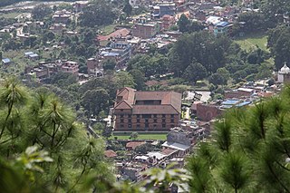
Gorkha District, a part of Gandaki Province, is one of the 77 districts of Nepal, which is the fourth largest district of Nepal and connected historically with the creation of the modern Nepal and the name of the legendary Gorkha soldiers. The district, with Gorkha Municipality as its district headquarters, covers an area of 3,610 km2 (1,390 sq mi) and has a population of 252,201 according to the 2021 Nepal census. Gorkha district is the site of the Manakamana Temple. The temples of Gorakh Nath and Gorakh Kali are found in the district. Several major rivers—the Chepe, Daraudi, Marsyangdi, Budi Gandaki, and Trishuli—run through the district.

Kaski District, a part of Gandaki Province, is one of the seventy-seven districts of Nepal. The name is disambiguated from Kaskikot, the ancient Kaski Kingdom.

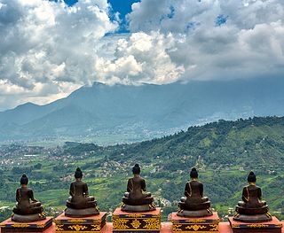
Parbat District (Nepali: पर्वत जिल्ला[pʌɾbʌt], is a hilly area of Nepal. It is a part of Gandaki Province and one of the seventy-seven districts of Nepal. The district, with Kusma as its district headquarters, covers an area of 494 km2 and has a population of 157,826. It is the fourth smallest district of Nepal with 47 VDCs currently.
Sarlahi, a part of Madhesh Province, is one of the seventy-seven districts of Nepal. According to new laws, a combination of more than two or four villages makes a municipality, which covers an area of 1,259 km2 (486 sq mi) and had a population of 635,701 in 2001 and 769,729 in 2011.

The administrative divisions of Nepal are subnational administrative units of Nepal. The first level of country subdivision of Nepal are the provinces. Each province is further subdivided into districts, each district into municipalities and rural municipalities, and each of those municipalities into wards. Before 2015, instead of provinces, Nepal was divided into developmental regions and administrative zones.

Changu Narayan is an ancient Hindu temple, located on a high hilltop that is also known as Changu or Dolagiri in Changunarayan Municipality of Bhaktapur District, Nepal. This hill is about 7 miles east of Kathmandu and a few miles north of Bhaktapur. The Manohara River flows beside the hill. The temple is considered to be one of the oldest temple in Nepal. The temple is dedicated to lord Vishnu and is held in special reverence by the Hindu people.
Lomanthang is a rural municipality in Mustang district in Gandaki Province of western Nepal. It is located at the northern end of the district, bordering the Tibet Autonomous Region of China to the north and Dalome rural municipality of Mustang in the south.

A village development committee in Nepal was the lower administrative part of its Ministry of Federal Affairs and Local Development. Each district had several VDCs, similar to municipalities but with greater public-government interaction and administration. There were 3,157 village development committees in Nepal. Each village development committee was further divided into several wards depending on the population of the district, the average being nine wards.
Kimadanda is a market center in Sandhikharka Municipality of Arghakhanchi District in the Lumbini Zone of Western Nepal. The former village development committee (VDC) was converted into municipality on 18 May 2014 by merging the existing Sandhikharka, Bangla, Narapani, Khanchikot, Kimadada, Argha and Dibharna VDCs. At the time of the 1991 Nepal census, the town had a population of 5,430 living in 1,085 houses. At the time of the 2001 Nepal census, the population was 3,514, of which 53% was literate.

Budhanilkantha is a city and municipality in Kathmandu district of Bagmati province of Nepal. It is the 3rd largest city in the Kathmandu Valley after Kathmandu and Lalitpur. As per 2021 Nepal census, the city population was 179,688 and 26,678 households.

Matatirtha is a village and former Village Development Committee that is now part of Chandragiri Municipality in Kathmandu District in Province No. 3 of central Nepal. At the time of the 1991 Nepal census it had a population of 2,799 living in 506 households. Its population has now grown to 5,982 spread over 1,314 households. Santosh Khadka was elected as Ward Chairman of Matatirtha through a local election.
Dhanushadham is a municipality in Dhanusha District in Province No. 2 of south-eastern Nepal. The municipality was established on 18 May 2014 by merging the existing Govindapur, Umprempur, Yagyabhumi, Dhanushadham village development committees (VDCs). It is a religious place of Hindu worship in Nepal. It is believed that a part of Shiva Dhanusha that was broken by Rama during Sita's swayamvara, is housed. Now there is temple around the remaining of bow and visited by Hindu devotees from all over the world. That's why it is named Dhanushadham.

Godawari is a municipality located in the Kailali District of Nepal.
Matihani is a municipality situated in Mahottari District of Nepal. The Municipality is well known for its historical significance and its festivities. The municipality was formed in 2016 from its current 9 wards from 9 former VDCs. It occupies an area of 29.02 sq. km with a total population of 31,026.

Bodebarsain is a municipality of Saptari District, Madhesh Province. It lies in the eastern Terai region of Nepal. It was officially upgraded to become a municipality in 2016, which otherwise was a Village Development Committee prior to that change. In order to meet the requirements to become a municipality, Bodebarsain merged Phulkahi, Manraja, Khadgapur, Deuri, Kachan, Sarashwar, Phulkahi, Negada and Dhanagadi VDC with itself. Bodebarsain spreads over an approximate area of 58.93 km2 (22.75 sq mi) and comprises 10 wards. According to 2011 census, the city had a population of 43,229.
Manraja is a village development committee (VDC) in the Saptari District, province No. 2, of south-eastern Nepal. It has a total area of 3.9 km2 (1.5 sq mi) and sits at an elevation of 89 m (292 ft). It is known for its landmark Shree Raja Ji Than Temple.
Shivanagar is a town in Krishnanagar Municipality in Kapilvastu District in the Lumbini Zone of southern Nepal. The former VDC was merged to form the municipality established on 18 May 2014 Krishnanagar, Sirsihawa, Shivanagar VDCs. At the time of the 2011 Nepal census it had a population of 4,774 people living in 735 individual households.

Letang, "लेटाङ " is a Municipality in Morang District in the Province No. 1 of south-eastern Nepal. It was formed by merging the existing Village Development Committees of Letang, Jante, Warrangi and Bhogateni. This municipality is situated in Hilly Region as well as Terai Region. Letang is full of natural beauty. Previously it was called Letang Bhogateni but now it's known as Letang.
Godawari is one of the popular hiking destinations in Nepal for its rich wildlife and splendid environment. Godawari is also famous for its botanical garden and Godawari temple. Mt. Phulchowki is located in Godawari which is the highest peak in Kathmandu valley.
Nagarjun is a municipality in Kathmandu District in Bagmati Province of Nepal. It was formed on 2 December 2014 by merging the former VDCs of Bhimdhunga, Ichangu Narayan, Ramkot, Syuchatar and Sitapaila. The office of the municipality is located at Harisiddhi, Sitapaila. There are ten wards in the municipality.


