Lele लेले Limwatidrang | |
|---|---|
 Lele Location in Nepal | |
| Coordinates: 27°34′N85°20′E / 27.57°N 85.34°E | |
| Country | |
| Zone | Bagmati Zone |
| District | Lalitpur District |
| Population (1991) | |
• Total | 6,928 |
| Time zone | UTC+5:45 (Nepal Time) |
Lele is a village development committee in Lalitpur District in the Bagmati Zone of central Nepal. At the time of the 1991 Nepal census it had a population of 6928 living in 1245 individual households, but the population has increased greatly since then. [1]
Contents
- Industry and agriculture
- Temples and gumbas
- Schools and colleges
- Health facilities
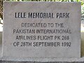
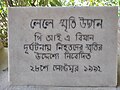
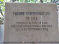
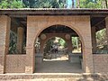
- PIA Memorial Park
- References
- External links
Lele is 14 km (1 hour by bus and about 30 minutes by bike) from Lagankhel, Patan, the main city of Lalitpur. It is located in a small valley within the Kathmandu Valley. The river is the main source for irrigation for the farmland.
Lele is a gateway to southern villages of Lalitpur including Bhardeu, Nallu, Chaughare and Gotikhel, and a centre of tourism. [2]
Lele was an important site under the ancient Licchavi dynasty; stone pillars dating to that era can be found there.