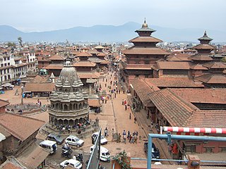
Lalitpur Metropolitan City, historically Patan, is the third largest city of Nepal after Kathmandu and Pokhara, and it is located in the south-central part of Kathmandu Valley, a new metropolitan city of Nepal. Lalitpur is also known as Manigal. It is best known for its rich cultural heritage, particularly its tradition of arts and crafts. It is city renowned for its festival and feast, fine ancient art, and the making of metallic and stone carved statues. At the time of the 2011 Nepal census it had a population of 226,728 in 54,748 individual households. The city received extensive damage from an earthquake on 25 April 2015.

Lalitpur District (Nepali: ललितपुर जिल्लाListen , a part of Bagmati Province, is one of the seventy-seven districts of Nepal. The district, with Lalitpur as its district headquarters, covers an area of 385 km2 and has a population of 337,785. It is one of the three districts in the Kathmandu Valley, along with Kathmandu and Bhaktapur. Its population was 466,784 in the initial 2011 census tabulation. It is surrounded by Makwanpur, Bhaktapur, Kathmandu & Kavre.

Birtamode is a municipality in Jhapa District of Nepal. It is the commercial, educational and transport hub of Jhapa District. Sarnamati Bazar, Dhulabari Bazar, Dhaijan Bazar, Charali Bazar, Shivasatakshi Bazar, Kamatoli Bazar, Chakchaki Bazar and Surunga Bazar are some of the nearest local towns/settlements connected to Birtamod. Birtamod is the largest city of Jhapa as well as in mechi zone.

Bhotang is a village in Sindhupalchok District in the Bagmati Zone of central Nepal. At the time of the 1991 Nepal census it had a population of 2750. 90 percent of its inhabitants are Tamang followed by Bishwakarma and Newar. There are three schools run by government. Among them, one is Bhotang Devi Secondary School. There is one bus that runs to and fro from Kathmandu once a day. The road condition is rough and dusty. Bhotang lies in Panchpokhari Rural Municipality. Mr. Ngima Chhiring Tamang is the ward chairman of Bhotang-3 ward.
Rigaun or Ree gaun is a village development committee in Dhading District in the Bagmati Zone of central Nepal. At the time of the 1991 Nepal census it had a population of 5218 and had 875 houses in it. Ree Gaun is located in the Northern part of Dhading. It consists of wards no 1 & 2 of Gangajamuna Rural Municipality, State 3, Dhading Nepal. There are 90% people of the Tamang ethnic group, and some are Gurung, Kami (BK), Damai. The main occupation of this area is agriculture.

Sundarijal is a village and former Village Development Committee that is now part of Gokarneshwar Municipality in Kathmandu District in Province No. 3 of central Nepal.
Bungkot is a village development committee in Gorkha District in the Gandaki Zone of northern-central Nepal. At the time of the 1991 Nepal census it had a population of 6,599, and there were 1,214 houses in the town.
Bhardeu is a village and former Village Development Committee that is now part of Konjyosom Rural Municipality in Province No. 3 of central Nepal. At the time of the 1991 Nepal census it had a population of 1746 in 310 individual households.
Dalchoki(Nepali: दलचोकी) is a village and former Village Development Committee that is now part of Konjyosom Rural Municipality in Province No. 3 of central Nepal. It is situated on the southern part of Lalitpur district, nearly 23 Kilometers from Patan, its district headquarters. This hilly region ranges from 1200 to 2300 meters from the sea level. At the time of the 1991 Nepal census it had a population of 1066 in 193 individual households.
Imadol is a village and former Village Development Committee that is now part of Mahalaxmi Municipality in Province No. 3 of central Nepal. It lies to the southeastern quarter of Patan, to the southeast of Kathmandu. At the time of the 2011 Nepal census it had a population of 27,327 living in 6,898 individual households. Until 2015, Imadol was a Village Development Committee. Imadol borders Lalitpur Sub-Metropolitan City (Patan) to the northwest, Greater Kathmandu to the north, Madhyapur Thimi to the northeast, Tikathali to the east, Sidhdipur to the southeast, Harisiddhi to the south and Dhapakhel to the southwest. Historians have documented that Imadol was visited by Emperor Ashoka in ancient times and his influence can be seen in the Ashoka stupas in the area.
Lele is a village development committee in Lalitpur District in the Bagmati Zone of central Nepal. At the time of the 1991 Nepal census it had a population of 6928 living in 1245 individual households, but the population has increased greatly since then.
Kharmi is a town and Village Development Committee in Khotang District in the Sagarmatha Zone of eastern Nepal. At the time of the 1991 Nepal census it had a population of 3,807 persons living in 723 individual households.
Solma is a village development committee in the Himalayas of Terhathum District in the Kosi Zone of eastern Nepal. At the time of the 1991 Nepal census it had a population of 4093 people living in 717 individual households. Solma is a Village Development Committee (VDC) lies on western part of Tehrathum District. The main ethnicity distribution of this VDC is Limbu (1190), Bramans (873), Kchhetri (663), Magar (381), Gurungs(287), Newar (166), Tamang (43) Kami (119)and Dam/Darji (100), Bhujel/Gharti (47). This VDC have one high school named Ratna Higher Secondary School, one Health Post, Post Office, Agriculture and Veterinary Center.
Khudunabari is a village development committee in Jhapa District in the Mechi Zone of south-eastern Nepal. At the time of the 1991 Nepal census, it had a population of 10,674 people living in 1867 individual households. It is connected via Sanischare Road to Mahendra Highway. Its neighbouring VDC s are Arjundhara,Lakshmipur and Shantipur of Illam District. It area comprises both plain and hilly. It has a moderate climate.
Chitlang is a village located in Thaha Municipality of Makwanpur District, Bagmati Pradesh, Nepal.
Kumroj is a town in Khairhani Municipality in Chitwan District in the Narayani Zone of southern Nepal. The municipality was promulgated on 18 May 2014 by merging the existing Khairahani, Kumroj and Chainpur VDCs. Kumroj is 190 km south-west of the Kathmandu valley stationed in the Rapti valley, also known as the Inner Terai or Dun. The village is situated at an altitude of 1000 ft above the sea level surrounded by two mountain ranges; the mahabharat ranges of hills on the north and the churiya siwalik hills on the south. The main point of attraction is the Chitwan National Park which today stands as a successful testimony of nature conservation in south Asia Region. Historically it was established in 1973 as the first national park of the Nepal to preserve a unique ecosystems significantly valuable to the whole world en routing this area on the world heritage site list in 1984. In the near future, this town would be one of the potential Eco-tourism village destination. Kumroj is dedicated to protect the wild animals, community forest and the Chitwan national park. Once the Southern belt of Nepal was afflicted by malaria epidemics. Tharu, the native tribe, were able to thrive even in malaria. As malaria subsided, more and more people started migrating in this place in the search of arable land, which eventually made Kumroj as a multicultural and multiethinic place. Irrigated low land has been the main stud of agriculture, permitting Rice-Rice-Pulse cropping pattern feasible.

Padampur is a municipality in Chitwan District in the Narayani Zone of southern Nepal. At the time of the 1991 Nepal census it had a population of 8884 people living in 1559 individual households. It was transferred in new location named Saguntol by Government of Nepal and completed with in 8 years i.e. from 2050 BS to 2058 BS. Previously it was at the lap of Rapati river and inside the Chitwan National Park. Flood of Rapati river in monsoon season destroy farmers crops. Wild animals also harmed their crops. Transportation, electricity, road and educational facilities were beyond people's access. It was known as one of the remote areas of the Chitwan district. In a view of agriculture, It was the best place for farmers. After the new dawn of democracy in 2046, New government was asked to shift this village for peoples safety and conservation of forest and wild animal. The cabinet of Girija Prasad Koirala was assured to shift in a convenience place soon and started the task immediately. This task was successfully done by the politician Baburam Puri of the Nepali Congress. The late Sailaja Acharya visited the people and understood their griefs and proposed to shift it next to Sagoontol near Jutpani VDC. This was a very difficult task to accomplish successfully. People from the Western Chitwan were stood against it but government took bold decision in favour of people of Padampur. Now it is about 2.5 km (1.6 mi) east to Bharatpur, district headquarters of Chitwan. Electricity, roads and transportation facility are comparatively better here. 2800 households were there now. According to the 2001 census, the total population of the VDC was 11336 with total households 2137. Tharus are the dominant ethnic group with 45.89% of the total VDC population. Brahman, Kshetri, Tamang, Gurung and Newar are other castes here. Mainly banana, maize and oil are farmed here. Except ward no 1 there are deep tubewells to Irrigate farmlands. Poultry, dairy, epiculture, mushroom farming and goat keeping have great potentials here. A campus, A higher secondary school, a secondary boarding school and other 7 primary and lower secondary schools are providing education here. Health post, and Post office are too doing their best for providing services to locals. Drinking water is provided in better and modern way. Pipelines of drinking water are available within all roads (113 km) of Padampur. An NGO veterinary office is also serving and helping farmers. Since last 5 years this VDC is starting to be known as one of pocket areas of commercial banana farming of the nation. Nobody is landless here and this is the special feature here. Padampur is very attractive location for migratory view and daily people are migrating here. It is like a colonial place for settlement of people. Government has sifted it in a well planned way and that is why it is the second model VDC of Nepal. Now this village has merged in Kalika Municipality and shares 4 wards in it i.e. Kalika -9, Kalika-10, Kalika-11 and Kalika-12.
Rajghat is a small village in the Urlabari Municipality, comprises two wards; 8 and 9 in the Morang District in the Koshi Zone of south-eastern Nepal. It is located in North-East part of Morang and 1.5 kilometers south of the East West national highway of Nepal. Durgapuri Bazar is the central emerging town of Rajghat.
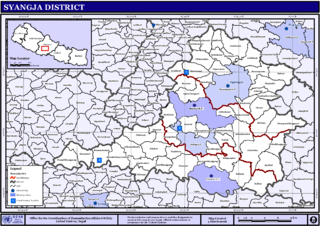
Pindikhola was a village development committee in Syangja District in the Gandaki Zone of central Nepal. At the time of the 2011 Nepal census it had a population of 4,956 people living in 1,119 individual households.
Mahalaxmi is a municipality that lies in the north-eastern part of the Lalitpur district of Nepal. As per the declaration by the government of Nepal in 2015, it was created through the merger of the Village development committees Imadol, Lubhu, Tikathali, Siddhipur and Lamatar. The city derives its name from the Mahalaxmi-Mahabhairav Temple in Lubhu. The city's total area is 26.5 square kilometres. The municipality has a total number of 10 wards. The old VDC offices are used as joint ward office now.

