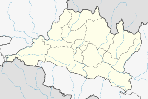
Lalitpur District (Nepali: ललितपुर जिल्लाListen , a part of Bagmati Province, is one of the seventy-seven districts of Nepal, a landlocked country of South Asia. The district, with Lalitpur as its district headquarters, covers an area of 385 km2 and has a population of 337,785. It is one of the three districts in the Kathmandu Valley, along with Kathmandu and Bhaktapur. Its population was 466,784 in the initial 2011 census tabulation. It is surrounded by Makwanpur,Bhaktapur, Kathmandu & Kavre.

Nuwakot District (Nepali: नुवाकोट जिल्लाListen , a part of Bagmati Pradesh, is one of the seventy-seven districts of Nepal, a landlocked country of South Asia. The district, with Bidur as its district headquarters, covers an area of 1,121 km2 and had a population of 288,478 in 2001 and 277,471 in 2011. It is a historically important district in Nepal. Prithvi Narayan Shah died in Devighat of Nuwakot.

Sarlahi, a part of Province No. 2, is one of the seventy-seven districts of Nepal. According to new laws, combination of more than 2 or 4 villages makes a municipality, which covers an area of 1,259 km2 (486 sq mi) and had a population of 635,701 in 2001 and 769,729 in 2011.

The administrative divisions of Nepal are subnational administrative units of Nepal. The first level of country subdivision of Nepal are the provinces. Each province is further subdivided into districts, each district into municipalities and rural municipalities, and each of those municipalities into wards. Before 2015, instead of provinces, Nepal was divided into developmental regions and administrative zones.

Bhattedanda is a village and former Village Development Committee that is now part of Bagmati Rural Municipality in Province No. 3 of central Nepal. At the time of the 1991 Nepal census it had a population of 2044 in 349 individual households.
Gimdi is one of former Village Development Committee of Lalitpur (Nepal). Now it lies in Ward no. 7 of Bagmati Rural Municipality, Lalitpur Province No. 3 of central Nepal. It is around 80 kilometer away from Kathmandu. According to National Population Census, 2011 of Nepal 2299 People of 461 household reside here. It has touched the border of Mahankal Rural Municipality of Lalitpur and Bagmati Rural Municipality of Makwanpur District.

Timure is a small town and headquarter of ward no. 2 of Gosaikund rural municipality. It is about 19 KM north from Syaphru.
'Ghusel is a village and former Village Development Committee that is now part of Bagmati Rural Municipality in Bagmati Pradesh of central Nepal. It is located southern part of Kathmandu Valley at similar or less heights. At the time of the 2011 Nepal census it had a population of 1510 in 308 individual households, down from the time of the 1991 Nepal census when it had a population of 1715 in 294 individual households.

Godawari is a municipality in Lalitpur District in Bagmati Pradesh of Nepal. It was established on 2 December 2014 by merging the former Village development committees Godawari, Badikhel, Bisankhunarayan, Godamchaur and Thaiba of Lalitpur District of Bagmati Zone. The municipality area was again expanded in March 2017 to include in total 12 previous VDCs. The six VDCs added were Devichaur, Dukuchhap, Chhampi, Thecho, Chapagaun, Jharuwarasi and Lele. The center of this rural municipality is located at Bajrabarahi. At the time of the 2011 Nepal census it had a population of 78,301 people living in 17,762 individual households. It is one of the popular hiking destinations in Nepal for its rich wildlife and splendid environment. Godawari is also famous for its botanical garden."Phulchoki" is located in Godawari which is the highest peak in kathmandu valley.

Province No. 2 is a province in the southeastern region of Nepal that was formed after the adoption of the Constitution of Nepal. It is Nepal's second most populous province, and smallest province by area. It borders Province No. 1 to the east, Bagmati Pradesh to the north, and India to the south. It has an area of 9,661 km2 (3,730 sq mi)-about 6.5% of the country's total area. With a population of 5,404,145 per the 2011 Census of Nepal, making it most densely populated province of Nepal.

Bagmati Province is one of the seven provinces of Nepal established by the constitution of Nepal as of 20 September 2015. With Hetauda as its provincial headquarter, the province is the home to the country's capital Kathmandu, is mostly hilly and mountainous, and hosts mountain peaks including Gaurishankar, Langtang, Jugal, and Ganesh. The province covers an area of 20,300 km2 - about 13.76% of the country's total area, and has an altitude low enough to support deciduous, coniferous, and alpine forests and woodlands. Temperature varies with altitude. Rainfall takes place mainly during the summer.
Gangajamuna is a Gaupalika(Nepali: गाउपालिका ; gaupalika) in Dhading District in the Bagmati Zone of central Nepal. The local body was formed by merging four VDCs namely Khari, Dhola, Nepal, Maidi and Chainpur, Bagmati. Currently, it has a total of 7 wards. The population of the rural municipality is 23,966 according to the data collected on 2017 Nepalese local elections.

Province No. 1 is a province of Nepal. It is located in easternmost part of Nepal. It is surrounded by Tibet of China to the north, the Indian states of Sikkim and West Bengal to the east and Bihar to the south and Bagmati Province and Province No. 2 to the west.
Konjyosom Rural Municipality is a Rural Municipality in Lalitpur District in Bagmati Pradesh of Nepal that was established in 2017 by merging the former Village development committees Sankhu, Dalchoki, Chaughare, Nallu and Bhardev.The center of this rural municipality is located at Chaughare. The major ethnic group of this rural municipality are Tamang. The name Konjyosom itself means Lord Buddha in Tamang language. According to 2011 Nepal census, Konjyosom has a population of 9,709.
Mahankal Rural Municipality Nepali: महाङ्काल गाउँपालिका, is a Rural Municipality in Lalitpur District in Bagmati Pradesh of Nepal that was established in 2017 by merging the former Village development committees Bukhel, Manikhel, Gotikhel, Chandanpur, Kaleshwar and Thuladurlung. The center of this rural municipality is located at Old-Gotikhel. According to 2011 Nepal census, Mahankal has a population of 9,453.
Gaurishankar Rural Municipality, a part of Bagmati Pradesh, Nepal, is a rural municipality located in Dolakha District. With Suri as its current official headquarter, the rural municipality consists of nine wards covers an area of 681.39 km² and has a population of 17062 in 2011.

Sunkoshi Rural Municipality is a rural municipality in Sindhuli district of Bagmati Pradesh in Nepal. The Rural municipality is divided into 7 wards. According to 2011 Nepal census, the total population of the municipality is 21,473 with 4,557 households. The total area of the municipality is 158.68 square kilometres (61.27 sq mi) The headquarter of the municipality is at Jhangajholi Ratmata.
Sunkoshi Rural Municipality is a rural municipality in Sindhupalchowk District of Bagmati Pradesh in Nepal. According to the 2011 Nepal census, the total population of the municipality is 16713 and total area of the municipality is 72.84 square kilometres (28.12 sq mi) The Rural municipality is divided into 7 wards and the headquarter of the municipality is located at Pangretar.