
Tamworth is a city and administrative centre of the north-western region of New South Wales, Australia. Situated on the Peel River within the local government area of the Tamworth Regional Council, it is the largest and most populated city in the region, with a population of 63,920 in 2021, making it the second largest inland city in New South Wales. Tamworth is 318 km (198 mi) from the Queensland border and is located almost midway between Brisbane and Sydney.

Peel River, a watercourse that is part of the Namoi catchment within the Murray–Darling basin, is located in the North West Slopes and Plains district of New South Wales, Australia.

The Tamworth Country Music Festival is an annual Australian music festival held for 10 days from Friday to Sunday in mid to late January each year, sometimes including Australia Day, in Tamworth, New South Wales. The festival is the second biggest country music festival in the world, after the CMA Music Festival in Nashville, Tennessee, USA.
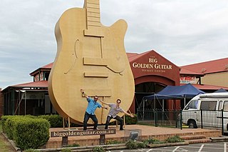
The Big Golden Guitar is one of the many "big" attractions that can be found around Australia. Located in Tamworth, New South Wales, the monument is one of the best-known points of interest in New England.

North Tamworth is a suburb of Tamworth, New South Wales, Australia, in the city's north. It is on the northerly side of the Peel River between the suburbs of East Tamworth and Oxley Vale. North of North Tamworth are the satellite suburbs Hills Plain, and Moore Creek. The Tamworth Base Hospital, Tamara Private Hospital, and many medical professionals' clinics. The suburb contains Northgate Shopping Centre and many sporting fields.
West Tamworth is a suburb of Tamworth, New South Wales, Australia, in the city's west. It is between South Tamworth and Taminda. It is an important commercial and residential area of Tamworth. In West Tamworth is the important commercial area of Bridge Street, which is one of the main roads connecting the northern side of Tamworth with the southern. The Oxley Highway runs through part of West Tamworth.
East Tamworth is a suburb of Tamworth, New South Wales, Australia, in the city's east. It is located between the suburbs of North Tamworth, Tamworth CBD and the satellite suburb of Nemingha. East Tamworth is one of the oldest settled areas of Tamworth, and therefore is known for its wide streets and historical buildings and homes. Many of these historical buildings are the highest valued properties in Tamworth. East Tamworth is home to ANZAC Park, Tamworth Public School, St Nicholas Primary School and Calrossy Anglican School.
Oxley Vale is a suburb of Tamworth, New South Wales, Australia, which runs either side of Manilla road. It is between the suburbs of North Tamworth and the satellite suburb of Hallsville. Oxley Vale is a largely residential suburb. Nazareth House nursing house is located there.

Hillvue is a suburb of Tamworth, New South Wales, Australia. It is a largely residential suburb of Tamworth and is south of South Tamworth. It has the second highest population estimate of any area of Tamworth, with over six thousand people in 2011.

The Tamworth Central Business District is a suburb of Tamworth, New South Wales, Australia, in the city centre and is located north of the Peel River. It is primarily a business area of Tamworth, with many shops, restaurants, car dealerships, as well as shopping centres and public facilities. The Tamworth Regional Council has its headquarters in Peel St at Ray Walsh House. Bicentennial Park and number one cricket oval are also located in the suburb.
Daruka is an outer suburb of Tamworth, New South Wales, in the city's north. It is located in the Daruka Valley north of the suburb North Tamworth and east of the locality of Moore Creek and is bounded in the north by the stream Moore Creek. To the east of Daruka is Moonbi and Kootingal. The neighbourhood of Upper Moore Creek 30°56′55″S150°59′05″E is within the north of the locality.

Peel High School is a government-funded co-educational dual modality partially academically selective and comprehensive secondary day school, located in Tamworth, a city in the northwest region of New South Wales, Australia.

Tamworth High School is a government-funded co-educational comprehensive secondary day school, located in Willis Street, South Tamworth, a suburb of the Tamworth Regional Council local government area in the New England region of New South Wales, Australia.

Nemingha is an outer suburb of Tamworth, New South Wales, Australia, 5 km east of the Tamworth Central Business District on the New England Highway. West of Nemingha is East Tamworth and the Tamworth Central Business District.
Kingswood is an outer-suburb of Tamworth, New South Wales, located south of the city. It is located off the New England Highway and is located south of the suburb Hillvue and is a largely rural residential suburb. North East/East of Kingswood is the suburb Calala.
Krui River, a perennial river of the Hunter River catchment, is located in the Upper Hunter region of New South Wales, Australia.
Duri is a village south of Tamworth in the New England region of New South Wales, Australia. It lies on the Werris Creek Road and the Main North railway line. At the 2011 census, Duri had a population of 534.
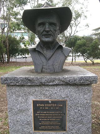
Stan Coster OAM was an Australian country music singer-songwriter. His songs were regularly performed by Slim Dusty and other singers. He is the father of country music singer Tracy Coster.
Kevin John Anderson is an Australian politician. Anderson is a member of the New South Wales Legislative Assembly representing Tamworth for the Nationals since 26 March 2011.

Barraba Shire was a local government area located in the New England region of New South Wales, Australia, about 90 kilometres (56 mi) north of Tamworth via Fossickers Way. The Shire, administered from the town of Barraba covered an area of 3,068.7 square kilometres (1,184.8 sq mi), and existed as a local government entity from 1906 until 2004, when it was split between two new LGAs, Gwydir Shire and Tamworth Regional Council.
