
Batavia, also called Batauia in the city's Malay vernacular, was the capital of the Dutch East Indies. The area corresponds to present-day Jakarta, Indonesia. Batavia can refer to the city proper or its suburbs and hinterland, the Ommelanden, which included the much-larger area of the Residency of Batavia in the present-day Indonesian provinces of Jakarta, Banten and West Java.

Tanjung Priok is a district of North Jakarta, Indonesia. It hosts the western part of the city's main harbor, the Port of Tanjung Priok. The district of Tanjung Priok is bounded by Laksamana Yos Sudarso Tollway and Sunter River canal to the east, by Kali Japat, Kali Ancol, and the former Kemayoran Airport to the southwest, by Sunter Jaya Road and Sunter Kemayoran Road to the south, and by Jakarta Bay to the north.

North Jakarta is one of the five administrative cities which form Special Capital Region of Jakarta, Indonesia. North Jakarta is not self-governed and does not have a city council, hence it is not classified as a proper municipality. It contains the entire coastal area within the Jakarta Special District. In North Jakarta, an area at the estuary of Ciliwung river was the main port for the kingdom of Tarumanegara, which later grew to become Jakarta. Many historic sites and artefacts of Jakarta can be found in North Jakarta. Both ports of Tanjung Priok and historic Sunda Kelapa are located in the city. The city, which covers an area of 139.99 km2, had 1,645,312 inhabitants at the 2010 Census, the latest official estimate is 1,827,731. It has its administrative centre in Tanjung Priok.

Ci Liwung is a 119 km long river in the northwestern region of Java where it flows through two provinces, West Java and the special region of Jakarta. The natural estuary of the Ciliwung river, known as the Kali Besar, was an important strategic point for trade in the precolonial and colonial periods and was instrumental in the founding of the port city of Jakarta, but has been lost from reorganization of the watercourse of the rivers around the area into canals.

Pasar Minggu is a district of South Jakarta, Jakarta, Indonesia. The area is known for its traditional Sunday market, famous for the fruit market. Historically, Pasar Minggu is a fruit cultivation area developed by the Dutch government during the colonial period. The central point of the cultivation area is the traditional market of Pasar Minggu, located in what is now Pasar Minggu Kelurahan. Teak forest could also be found in Pasar Minggu district, notably around Jati Padang Kelurahan. Most of these areas has been converted into residential area as Jakarta grow southward.

Sawah Besar is a subdistrict (kecamatan) of Central Jakarta, Indonesia. The neighborhoods within the subdistrict are among the most historic subdistrict in Jakarta, containing the 1820-established Pasar Baru, the colonial administrative center of Weltevreden, as well as the old course of the Ciliwung. Many colonial landmarks are located in the subdistrict, e.g. the Lapangan Banteng, the A.A. Maramis Building, and the Jakarta Cathedral.

Jatinegara is one of the districts (Kecamatan) of East Jakarta, Indonesia. The name also refers to the larger, historic area of the colonial town of Meester Cornelis. Established in the 17th century, Jatinegara is one of the oldest areas in Jakarta, and contains a number of buildings from the colonial period.
Jagakarsa is a district of South Jakarta, one of the administrative cities in Jakarta Indonesia. Jagakarsa is the southernmost district of South Jakarta Jagakarsa District is bounded by Ciliwung River to the east, Krukut River to the west, and Margasatwa-Sagu-Joe-T.B.Simatupang-Poltangan Road to the north, while the boundary marches with Depok city to the south.

Kebayoran Baru is a district of South Jakarta, Indonesia. The name of the district was derived from an area which was developed in the post-war period as a new suburb town of Jakarta, Kebayoran Baru. Kebayoran Baru was the last residential area to be developed by the Dutch colonial administration. The urban planning was laid in a concept of the Garden city movement, consisting of a well-planned residential area, a shopping center, and a business district, supported with civic facilities e.g. schools, places of worship, hospitals, and parks. Many important governmental institutions are located in Kebayoran Baru, such as the Indonesia Stock Exchange building, the ASEAN Secretariat building, the Criminal Investigation Agency of the National Police, and the City Hall of South Jakarta. Sudirman Central Business District is also located in Kebayoran Baru sub-district.

Jakarta is Indonesia's capital and largest city. Located on an estuary of the Ciliwung River, on the northwestern part of Java, the area has long sustained human settlement. Historical evidence from Jakarta dates back to the 4th century CE, when it was a Hindu settlement and port. The city has been sequentially claimed by the Indianized kingdom of Tarumanegara, the Hindu Kingdom of Sunda, the Muslim Sultanate of Banten, and by Dutch, Japanese and Indonesian administrations. The Dutch East Indies built up the area before it was taken during World War II by the Empire of Japan and finally became independent as part of Indonesia.

A landhuis is a Dutch colonial country house, often the administrative heart of a particuliere land or private domain in the Dutch East Indies, now Indonesia. Many country houses were built by the Dutch in other colonial settlements, such as Galle, Cape Town and Curaçao, but none as extensively or elaborately as in the Residency of Batavia. Much of Batavia's reputation as "Queen of the East" rested on the grandeur of these 18th-century mansions.
Frans Johan Louwrens Ghijsels was a Dutch architect and urban planner who worked in the Netherlands and the Dutch Indies. Ghijsels was the founder of AIA, the biggest architecture consultant in the Dutch Indies. He was one of the instrumental architect in developing a modern style characteristic of the Dutch Indies.
Kwitang is an administrative village (kelurahan) in the subdistrict (kecamatan) of Senen, Central Jakarta. It is one of the historic administrative village of Jakarta. The boundary of Kwitang is the Ciliwung to the west, Jalan Kramat Kwitang to the north, Jalan Kramat Raya to the east, and Jalan Kramat 4 to the south.
Tandjong Oost, also known as Groeneveld, was a particuliere land, or private domain, in modern-day Jatinegara, East Jakarta, Indonesia. It was one of two estates located on the banks of the Ciliwung river: Tandjong Oost to the east of the river, and Tandjong West to the west.

Jalan Gajah Mada and Jalan Hayam Wuruk, formerly Molenvliet West and Molenvliet Oost respectively, is a major thoroughfare located in Jakarta, Indonesia. The two streets with its canal, the Batang Hari, connected Glodok and Kota Tua Jakarta to the north with Harmoni Junction to the south. Completed in late 1640s, the canal-street Gajah Mada and Hayam Wuruk is Jakarta's oldest major thoroughfare.

Krukut River is a river flowing in Jakarta originating in Bogor Regency. In the past the river was clean and one of the tourist attractions during the Dutch East Indies administration, but due to denser housing on the banks and lack of maintenance, the water turned dark and filled with trash, causing routine flooding in rainy seasons.
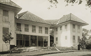
Gedong Tinggi Palmerah is an 18th-century Dutch Indies country house located in Jakarta, Indonesia. The building is among the protected colonial heritage of Indonesia. Like many other colonial country houses of Jakarta, despite its protection by the government, the lack of interest in the study of the building caused it to slowly fall into disrepair. It was converted into a police station.
Tan Liok Tiauw Sia was a prominent Chinese-Indonesian landlord, as well as a pioneering plantation owner and industrialist in the late colonial period. He was the last Landheer of Batoe-Tjepper, today's district of Batuceper.
Baru Timur River is a man-made canal flowing from Ci Liwung in Bogor Regency to Jakarta, Indonesia. It was one of two canals built in the 18th century under the order of the Governor-General Gustaaf Willem van Imhoff originally to transport agriculture harvest from Bogor to Batavia. Currently both canals, now known as Kali Baru Timur and Kali Baru Barat, are among the main rivers in Jakarta, and part of the Ciliwung Cisadane flood control project. Baru Timur River flows from Katulampa flood gate, built at the same time as the canal, along the major road Bogor Highway, passing Cimanggis, Depok, Cilangkap, until reaching Java Sea in Kali Besar, Tanjung Priok, North Jakarta.
Baru Barat River is a man-made canal flowing from Cisadane River in Bogor Regency to Jakarta, Indonesia. It was one of two canals built in the 18th century under the order of the Governor-General Gustaaf Willem van Imhoff originally to transport agriculture harvest from Bogor to Batavia. Currently both canals, now known as Kali Baru Timur and Kali Baru Barat, are among the main rivers in Jakarta, and part of the Ciliwung Cisadane flood control project. Flowing through the areas of Pancoran and Tebet, South Jakarta, among others, Baru Barat River is one of the drainages that flow the water into Banjir Kanal Barat.

