Halebidu is a town located in Hassan District, Karnataka, India. Halebidu was the regal capital of the Hoysala Empire in the 12th century. It is home to some of the best examples of Hoysala architecture. Most notable are the ornate Hoysaleshwara and Kedareshwara temples. The city got the name "Halebidu" because it was damaged and deserted into "old capital" after being ransacked and looted twice by Islamic forces of the Delhi Sultanate in the 14th-century.

Zaragoza, also called Saragossa in English, is a province of northern Spain, in the central part of the autonomous community of Aragon. Its capital is Zaragoza, which is also the capital of the autonomous community. Other towns in Zaragoza include Calatayud, Borja, La Almunia de Doña Godina, Ejea de los Caballeros and Tarazona.

Gandhinagar is the capital of the state of Gujarat in Western India. Gandhinagar is located approximately 23 km north of Ahmedabad, on the west central point of the Industrial corridor between Delhi, the political capital of India, and Mumbai, the financial capital of India.

Comayagua is a city in Honduras, some 50 miles (80 km) northwest of Tegucigalpa on the highway to San Pedro Sula at an elevation of 1,949 feet above sea level.
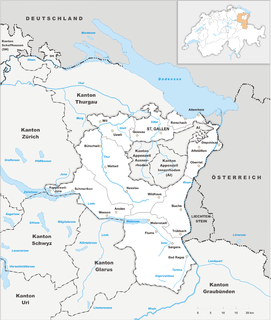
The canton of St. Gallen, also canton of St Gall, is a canton of Switzerland. The capital is St. Gallen.

Cherry Plain State Park is a 175-acre (0.71 km2) state park located in Rensselaer County, New York in the United States. The park is located in Cherry Plain at the southwest part of the Town of Berlin, near the Massachusetts border. Outdoor recreational opportunities are also available within the Capital District Wildlife Management Area, a 4,153-acre (16.81 km2) conservation area that nearly surrounds the park.

There are six main administrative districts of Israel, known in Hebrew as mehozot and Arabic as mintaqah and fifteen sub-districts known as nafot. Each sub-district is further divided into cities, municipalities, and regional councils it contains.

Belur, (IPA: [beːluːru]; is a Town Municipal Council and taluka in Hassan district in the state of Karnataka, India. The town is renowned for its Chennakeshava Temple, one of the finest examples of Hoysala architecture.

The National Capital Region (NCR) is a central planning region centred upon the National Capital Territory of Delhi in India. It encompasses the entire NCT of Delhi and several districts surrounding it from the states of Haryana, Uttar Pradesh and Rajasthan. The NCR and the associated National Capital Region Planning Board were created in 1985 to plan the development of the region and to evolve harmonized policies for the control of land-uses and development of infrastructure in the region. Prominent cities of NCR include Delhi, Gurgaon, Noida, Faridabad and Ghaziabad.
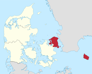
The Capital Region of Denmark is the easternmost administrative region of Denmark, established on January 1, 2007 as part of the 2007 Danish Municipal Reform, which abolished the traditional counties and set up five regions. At the same time, smaller municipalities were merged into larger units, cutting the number of municipalities from 271 before 1 January 2006, when Ærø Municipality was created, to 98. The Capital Region has 29 municipalities. The reform was implemented on January 1, 2007. The main task for the Danish regions are hospitals and healthcare. It is not to be confused with the Copenhagen Metropolitan Area nor with the Øresund Region. Unlike the counties (1970-2006) the regions are not municipalities and are thus not allowed to have coat of arms, but only logotypes, and cannot "shuffle money around" from one area of expenditure to another area of expenditure, that is, use money for any other purpose than has been stated specifically, but must pay money not used back rather like departments or agencies of the central government. The regions do not levy any taxes but are financed only through block grants.

Bharatpur is a city and a municipal corporation in the Indian state of Rajasthan. The city is situated 180 km south of India's capital, New Delhi, 178 km from Rajasthan's capital Jaipur, 55 km west of Agra of Uttar Pradesh and 38 km from Mathura of Uttar Pradesh. It is also the administrative headquarters of Bharatpur District and the headquarters of Bharatpur Division of Rajasthan State. Bharatpur is part of National Capital Region (NCR) of India.

Rajgad is a hill fort situated in the Pune district of Maharashtra, India. Formerly known as Murumdev, the fort was the capital of the Maratha Empire under the rule of Chhatrapati Shivaji Maharaj for almost 26 years, after which the capital was moved to the Raigad Fort. Treasures discovered from an adjacent fort Torna were used to completely build and fortify the Rajgad Fort.

Richeval is a commune in the Moselle department in Grand Est in north-eastern France. Richeval is situated in the Moselle, Lorraine region, in the north-east of France at 76 km from Metz, the department capital..
Halyal is a village in Belgaum district in the southern state of Karnataka, India. It is located 121 kilometres (75 mi) north of Belgaum, 10 kilometres (6.2 mi) from Athani, and 577 kilometres (359 mi) from the state capital of Bangalore.
Kalabhavi is a village in Belgaum district in Karnataka, India.
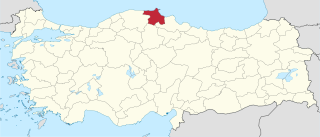
Sinop Province is a province of Turkey, along the Black Sea. It is located between 41 and 42 degrees North latitude and between 34 and 35 degrees East longitude. The surface area is 5,862 km², equivalent to 0.8% of Turkey's surface area. The borders total 475 km and consists of 300 km of land and 175 km seaside borders. Its adjacent provinces are Kastamonu on the west, Çorum on the south, and Samsun on the southeast. The provincial capital is the city of Sinop.

Amaravati is the de facto capital city of the Indian state of Andhra Pradesh. The planned city is located on the southern banks of the Krishna river in Guntur district, within the Andhra Pradesh Capital Region, being built on a 217 sq km riverfront designed to have 51% of green spaces and 10% of water bodies. The word "Amaravati" derives from the historical Amaravathi Temple town, the ancient capital of the Satavahana dynasty. The foundation stone was laid on 22 October 2015, at Uddandarayunipalem area by the Prime Minister, Narendra Modi. The metropolitan area of Guntur and Vijayawada are the major conurbations of Amaravati.