Tapi River, Thailand

Last updated
Waterfront, Surat Thani Surat Thani waterfront.jpg
Waterfront, Surat Thani

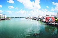
The Tapi (or Tapee) river (Thai : แม่น้ำตาปี, RTGS: Maenam Tapi, Thai pronunciation:  [mɛ̂ːnáːm tāːpīː] ) is the longest river in southern Thailand. The river originates at Khao Luang mountain in Nakhon Si Thammarat Province, and empties into the Gulf of Thailand at Bandon Bay near the town of Surat Thani. It has a length of 230 kilometres (140 mi).

Thai language language spoken in Thailand

Thai, Central Thai or Ayutthaya or Siamese, is the sole official and national language of Thailand and the first language of the Central Thai people and vast majority of Thai of Chinese origin. It is a member of the Tai group of the Kra–Dai language family. Over half of Thai vocabulary is derived from or borrowed from Pali, Sanskrit, Mon and Old Khmer. It is a tonal and analytic language.

The Royal Thai General System of Transcription (RTGS) is the official system for rendering Thai words in the Latin alphabet. It was published by the Royal Institute of Thailand.

Southern Thailand Region in Hat Yai

Southern Thailand is a southernmost cultural region of Thailand, separated from Central Thailand region by the Kra Isthmus.

The river drains an area of 5,460 square kilometres (2,110 sq mi) and in 1997 had a yearly discharge of 135.4 cubic metres per second (4,780 cu ft/s) or 4.3 cubic kilometres (3,500,000  acre⋅ft ) per year. The Phum Duang River (or Khiri Rat River), which drains another 6,125 square kilometres (2,365 sq mi) west of the Tapi watershed, joins the estuary 15 kilometres (9 mi) west of Surat Thani in Amphoe Phunphin.

The Phum Duang River is a river in Surat Thani Province, southern Thailand, the main tributary of the Tapi River.

The river was named on 29 July 1915, after the river Tapi in Surat, India, shortly after the town of Surat Thani was named after the town Surat in Gujarat, India.

Tapti River river in India

The Tapti River is a river in central India between the Godavari and Narmada rivers. It flows westwards over a length of 724 km (449.9 mi) before draining through the Gulf of Khambhat into the Arabian Sea. It flows through Surat, and is crossed by the Magdalla ONGC Bridge.

Surat Metropolis in Gujarat, India

Surat is a city in the Indian state of Gujarat. It used to be a large seaport and is now a center for diamond cutting and polishing. It is the eighth largest city and ninth largest urban agglomeration in India. It is the administrative capital of the Surat district. The city is located 284 kilometres (176 mi) south of the state capital, Gandhinagar; 265 kilometres (165 mi) south of Ahmedabad; and 289 kilometres (180 mi) north of Mumbai. The city centre is located on the Tapti River, close to Arabian Sea.

India Country in South Asia

India, also known as the Republic of India, is a country in South Asia. It is the seventh largest country by area and with more than 1.3 billion people, it is the second most populous country and the most populous democracy in the world. Bounded by the Indian Ocean on the south, the Arabian Sea on the southwest, and the Bay of Bengal on the southeast, it shares land borders with Pakistan to the west; China, Nepal, and Bhutan to the northeast; and Bangladesh and Myanmar to the east. In the Indian Ocean, India is in the vicinity of Sri Lanka and the Maldives, while its Andaman and Nicobar Islands share a maritime border with Thailand and Indonesia.

The island of Ko Lamphu (เกาะลำพู) is in the Tapi River, about 9 kilometres (6 mi) from its mouth, near Surat Thani town center. [1]

Ko Lamphu island in Tapi River, Surat Thani, Thailand

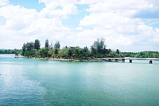
Ko Lamphu (เกาะลำพู) is a small island in the Tapi River, Thailand, about 9 km from the river's mouth, near the town center of Surat Thani. It is connected by bridge to the city at the pillar shrine.

In 1975, an area of 29.6 square kilometres (11.4 sq mi) of swamp land on the east bank of the river in the Khian Sa District was declared the Nong Thung Thong non-hunting area.

Nong Thung Thong non-hunting area in Surat Thani province, Thailand

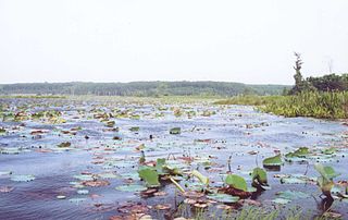
Nong Thung Thong is a swamp on the east bank of the Tapi River in Khian Sa District, Surat Thani Province, southern Thailand.

Related Research Articles

Saône river of France

The Saône is a river of eastern France. It is a right tributary of the Rhône, rising at Vioménil in the Vosges department and joining the Rhône in Lyon, just south of the Presqu'île.

Kaveri river in South India

Kaveri, also referred as Ponni, is an Indian river flowing through the states of Karnataka and Tamil Nadu. It is the third largest after Godavari and Krishna in south India and the largest in Tamil Nadu which on its course, bisects the state into North and South. Originating in the foothills of Western Ghats at Talakaveri, Kodagu in Karnataka it flows generally south and east through Karnataka and Tamil Nadu and across the southern Deccan plateau through the southeastern lowlands, emptying into the Bay of Bengal through two principal mouths in Poompuhar, Tamil Nadu. Amongst the river valleys, the Kaveri delta forms one of the most fertile regions in the country.

Surat Thani Province Province in Thailand

Surat Thani, often shortened to Surat, is the largest of the southern provinces (changwat) of Thailand. It lies on the western shore of the Gulf of Thailand. Surat Thani means "city of good people", a title given to the city by King Vajiravudh.

Surat Thani City Municipality in Thailand

Surat Thani is a city in Amphoe Mueang Surat Thani, Surat Thani Province, southern Thailand. It lies 651 km south of Bangkok. It is the capital of Surat Thani Province. The city has a population of 128,179 (2009), and an area of 68.97 square kilometers. The city's population density is 1,858.47 inhabitants per km².

Phunphin District Amphoe in Surat Thani, Thailand

Phunphin is a district (amphoe) in Surat Thani Province in the south of Thailand. Tha Kham is the principal town of the district. In 2014, the population was 73,067.

Ghaghara perennial trans-boundary river originating on the Tibetan Plateau near Lake Mansarovar

Ghaghara, also called Karnali is a perennial trans-boundary river originating on the Tibetan Plateau near Lake Manasarovar. It cuts through the Himalayas in Nepal and joins the Sharda River at Brahmaghat in India. Together they form the Ghaghara River, a major left bank tributary of the Ganges. With a length of 507 kilometres (315 mi) it is the longest river in Nepal. The total length of Ghaghara River up to its confluence with the Ganges at Revelganj in Bihar is 1,080 kilometres (670 mi). It is the largest tributary of the Ganges by volume and the second longest tributary of the Ganges by length after Yamuna.

Daman Ganga River river in western India

The Daman Ganga also called Dawan River is a river in western India. The river's headwaters are on the western slope of the Western Ghats range, and it flows west into the Arabian Sea. The river flows through Maharashtra and Gujarat states, as well as the Union territories of Daman and Diu and Dadra and Nagar Haveli. The industrial towns of Vapi, Dadra and Silvassa lie on the north bank of the river, and the town of Daman occupies both banks of the river's estuary.

The Pran Buri River is a river in Prachuap Khiri Khan Province, Thailand, on the Kra Isthmus of the Malay Peninsula. The Pran Buri River originates in southern part of the Kaeng Krachan National Park in the Tenasserim Hills and after 130 kilometres (81 mi) empties into the Gulf of Thailand. The only town along the river course is Pran Buri, the center of the Pran Buri District. The watershed of the Pran Buri River has an area of about 2,000 square kilometres (770 sq mi).

Mueang Surat Thani District Place in Surat Thani, Thailand

Mueang Surat Thani, formerly named the Ban Don District, is the capital district of Surat Thani Province in southern Thailand.

Tha Kham is a town in southern Thailand. As of 2006 it covered an area of 14.10 km² and had a population of 20,349. It covers parts of the subdistrict (tambon) Tha Kham of Phunphin District, Surat Thani Province. It is on the shores of the Tapi River. The Surat Thani Railway Station is in town center.

Surat Thani railway station railway station in Thailand

Surat Thani railway station is the main railway station in Surat Thani Province, Thailand. It is on the State Railway of Thailand (SRT) Southern Line, located 635.106 km from Thon Buri railway station. The station is on the east bank of Tapi River in Tha Kham town, Phun Phin District. Surat Thani Station first opened in 1915, and was originally named Phun Phin Station. The name was later changed to "Surat Thani railway station".

Khao Tha Phet non-hunting area in Surat Thani province, Thailand

Khao Tha Phet is a hill near the town of Surat Thani, southern Thailand. It is located in Tambon Makham Tia, Amphoe Mueang Surat Thani. The hill has an altitude of about 210m (689ft) above sea level and offers a good view over the town Surat Thani.

Khian Sa District District in Surat Thani, Thailand

Khian Sa is a district (amphoe) in Surat Thani Province, Thailand.

Gandhi Sagar Dam dam

The Gandhi Sagar Dam is one of the four major dams built on India's Chambal River. The dam is located in the Mandsaur, Neemuch districts of the state of Madhya Pradesh. It is a masonry gravity dam, standing 62.17 metres (204.0 ft) high, with a gross storage capacity of 7.322 billion cubic metres from a catchment area of 22,584 km2 (8,720 sq mi). The dam's foundation stone was laid by Prime Minister of India Pandit Jawaharlal Nehru on 7 March 1954, and construction of the main dam was done by leading contractor Dwarka Das Agrawal & Associates and was completed in 1960. Additional dam structures were completed downstream in the 1970s.

River systems of Thailand

Thailand has 25 river basins with 254 sub-basins. Rainwater is one of the most important sources of water. Thailand's water resource per capita is less than that of other countries in the region.

The Aschiagar is a river of Mangystau Region of Kazakhstan, and runs some 40 kilometres (25 mi) to the east of the city of Aktau.

Pazhassi Dam dam in India

The Pazhassi Dam also called Kulur Barrage is a stone masonry diversion structure in Kannur district, Kerala, India. It is named after king Pazhassi Raja, a local warrior. The dam is constructed across the west flowing Valapattanam River near VELIYAMBRA. It was commissioned by Prime Minister Morarji Desai in 1979. It mainly functions as an irrigation dam, serving a command area of 11,525 hectares in Thalassery and Thaliparambra taluks of the Kannur District. The water from this dam also meets the drinking water requirement of Kannur district. The dam site and the reservoir are famous for their scenic beauty.

References

Coordinates: 9°11′50″N99°22′57″E / 9.19722°N 99.38250°E / 9.19722; 99.38250