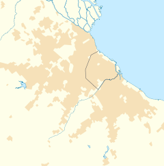
Avellaneda is a port city in the province of Buenos Aires, Argentina, and the seat of the Avellaneda Partido, whose population was 342,677 as per the 2010 census [INDEC]. Avellaneda is located within the Greater Buenos Aires metropolitan area, and is connected to neighboring Buenos Aires by several bridges over the Riachuelo River.

Ezeiza is the capital city of the Ezeiza Partido within the Greater Buenos Aires area in Argentina. The city had a population of 160,219 in 2010. Ezeiza is one of the fastest-growing cities in Argentina; the city and its surroundings are known for the many gated communities there, as well as for the Ministro Pistarini International Airport and the Ezeiza Federal Prison Complex. Ezeiza and its surrounds are known as affluent areas.

San Vicente is a town and administrative centre of San Vicente Partido, in the province of Buenos Aires, Argentina. The southernmost town in the Greater Buenos Aires metropolitan area, San Vicente is 48 km (30 mi) from downtown Buenos Aires, and can be accessed from Constitución Station by bus via Line 79 or a 20-minute drive by Provincial Route 58 from Ezeiza International Airport. The city has about 21,000 inhabitants per the 2001 census [INDEC].

Pinamar is an Argentine coastal resort city located on the coast of the Atlantic Ocean in Buenos Aires Province. It has about 45,000 inhabitants (2020).

Banco de la Nación Argentina is a national bank in Argentina, and the largest in the country's banking sector.

Remedios de Escalada is a city located in Buenos Aires Province, Argentina, within Lanús Partido, Gran Buenos Aires. It covers an area of 9.95 km² and the population was 81,465 in 2001; the demonym for its inhabitants is "escaladense."
Merlo is the head town of the eponymous partido of Merlo and seat of the municipal government, located in the Greater Buenos Aires urban area of Buenos Aires Province, Argentina.

The General Manuel Belgrano Railway (FCGMB), named after the Argentine politician and military leader Manuel Belgrano, is a 1,000 mmmetre gauge railway and the longest of the Argentine system. It was one of the six State-owned Argentine railway companies formed after President Juan Perón's nationalisation of the railway network in 1948.

The Province of Buenos Aires Railway was a state-owned company that operated a 902 km 1,000 mmmetre gauge railway network in the Province of Buenos Aires in Argentina. Founded in 1907 as the "Ferrocarril Provincial del Puerto de La Plata al Meridiano V", the company changed its name to FCPBA in 1924. In 1951 it was taken into state ownership and in 1953 it was absorbed by the state-owned Belgrano Railway. The FCPBA should not confused with the similarly named French–owned Compañía General which also operated in the Province.

The Belgrano Sur line is an Argentine 1,000 mmmetre gauge commuter rail service in the Greater Buenos Aires area, currently operated by state-owned enterprise Trenes Argentinos. The Belgrano Sur runs over tracks and through stations built by the Franco–Belgian-owned Compañía General de Buenos Aires and British Midland companies at the beginning of the 20th century.

Versalles is a barrio (district) of Buenos Aires, Argentina. It is part of Commune 10 along with Villa Real, Monte Castro, Floresta, Velez Sarsfield and Villa Luro. Versalles is located on the western end of Buenos Aires; its boundaries are marked by the following streets: Nogoyá, Irigoyen, Juan B. Justo Avenue, and the General Paz Expressway.

Llavallol is a district of Lomas de Zamora Partido in Buenos Aires Province, Argentina. It forms part of the Greater Buenos Aires urban conurbation.

Avellaneda Park is a public park in Buenos Aires, Argentina. It is located at the heart of the Parque Avellaneda neighbourhood, which takes its name from the park.

Nicolás Mihanovich (1846–1929) was a Croatian Argentine businessman closely linked to the development of the Argentine merchant marine.

The Buenos Aires Central Business District is the main commercial centre of Buenos Aires, Argentina, though not an official city ward. While the barrios of Puerto Madero and Retiro house important business complexes and modern high-rise architecture, the area traditionally known as Microcentro is located within San Nicolás and Monserrat, roughly coinciding with the area around the historic center of the Plaza de Mayo. The Microcentro has a wide concentration of offices, service companies and banks, and a large circulation of pedestrians on working days. Another name given to this unofficial barrio is La City, which refers more precisely to an even smaller sector within the Microcentro, where almost all the banking headquarters of the country are concentrated.

The Port of Buenos Aires is the principal maritime port in Argentina. Operated by the Administración General de Puertos, a state enterprise, it is the leading transshipment point for the foreign trade of Argentina.

The Buenos Aires Great Southern Railway (BAGS) was one of the Big Four broad gauge, 5 ft 6 in, British-owned companies that built and operated railway networks in Argentina. The company was founded by Edward Lumb in 1862 and the first general manager was Edward Banfield after whom the Buenos Aires suburban station of Banfield was named, when it opened in 1873. After president Juan Perón nationalised the Argentine railway network in 1948 it became part of the state-owned company Ferrocarril General Roca.
La Tablada is a city in Argentina. It is located in La Matanza Partido and is part of the Greater Buenos Aires metro area.
Ciudad Madero, also known as Villa Eduardo Madero, is a city in La Matanza Partido, Buenos Aires Province, Argentina. It is located within the Greater Buenos Aires metropolitan area.
Ranelagh is a town in Berazategui Partido, in the southeastern section of Greater Buenos Aires.