Merlo Partido

Last updated
Merlo
Partido de Merlo
Coat of Arms of Merlo.svg
Municipio merlo logo.png
Argentina - Buenos Aires - Merlo.svg
location of Merlo Partido in Gran Buenos Aires
Coordinates: 34°40′S58°43′W / 34.667°S 58.717°W / -34.667; -58.717
Country Argentina
EstablishedAugust 28, 1755
Founded byFrancisco Javier de Merlo y Barbosa
Seat Merlo
Government
  MayorGustavo Menendez (PJ)
Area
  Total170 km2 (70 sq mi)
Population
[1]
  Total524,207
  Density3,100/km2 (8,000/sq mi)
Demonym merlense
Postal Code
B1722
IFAM
Area Code0220
Patron saintNuestra Señora de la Merced

Merlo is a partido of Buenos Aires Province, Argentina. It is located in Greater Buenos Aires, Argentina, west of the city of Buenos Aires. Its capital is the city of Merlo.

Contents

The region of the present-day partido was colonized shortly after the second, and permanent founding of Buenos Aires (1580). In 1730 an interim parish was founded near the estancia (landholding) of Francisco de Merlo. In 1755 Merlo founded the town of Villa San Antonio del Camino, which was renamed later in his honour. For many years, the development of Merlo lagged behind the growth of nearby Morón. In 1865 the region was officially declared a partido.

Geography

Cities: Merlo, San Antonio de Padua, Parque San Martin, Mariano Acosta, Libertad and Pontevedra Partido de Merlo 02.JPG
Cities: Merlo, San Antonio de Padua, Parque San Martín, Mariano Acosta, Libertad and Pontevedra

Merlo covers 170 km2 (66 sq mi) and is bordered by the partidos of Morón and Ituzaingó (northeast), La Matanza (southeast), Marcos Paz (southwest), and Moreno and the Reconquista River (northwest). Besides the city of Merlo, the significant localities are San Antonio de Padua, Parque San Martín, Libertad, Pontevedra and Mariano Acosta. The city of Merlo was formerly important solely as a railroad junction and trade centre for the surrounding agricultural and pastoral lands.

About half of the partido now lies within the Greater Buenos Aires urban area, and the population density is less than that of most of the metropolitan partidos of Buenos Aires Province.

History

1755: Francisco de Merlo and Villa San Antonio del Camino

In the early 17th century the present-day partido was part of the Pago (from the Latin pagus, country district) of Las Conchas; the territory was traversed by the Reconquista River, known in those days as Río de las Conchas (literally River of Shells) from where the region took its name. The region was largely inhabited by the taluhet people, part of the het nation, a hunter-gatherer society better known by the exonym querandi.

In 1636 the territory of today's Merlo was divided into a few haciendas, given as land grants by Governor Pedro Esteban Dávila to a few and influential Buenos Aires neighbors.

Inside the haciendas the main economical activities were the agriculture and cattle-raising. The fertile land —drained by Las Conchas/Reconquista River— was covered with wheat fields and orchards. The bigger hacienda was granted to the Company of Jesus and the resulting production provided the Jesuits the financial resources to maintain the schools they had in Buenos Aires.

The Jesuit priests Thomas Falkner [2] and Florian Paucke [3] visited the region in the mid 18th century and described the area plenty of herds of feral cattle and horses roaming free on the plains and numerous packs of dogs that feed on them and sometimes attacked the unwarned and helpless travelers.

La vuelta del malon (The return of the raiders) by Angel Della Valle (1892), Museo Nacional de Bellas Artes. Angel DELLA Valle - La vuelta del malon - Google Art Project (cropped).jpg
La vuelta del malón (The return of the raiders) by Ángel Della Valle (1892), Museo Nacional de Bellas Artes.

By the 18th century the Araucanian people were moving from the lap of the Andes Mountains to the Pampas, attracted by the numerous cattle and horses herds. The Araucanians looted and sacked the Spanish settlements around Buenos Aires, performing unexpected horse mounted attacks known in the Southern Cone as malones (s. malón, from Mapudungun malocán: “to make war”).

By those days the Spanish businessman Francisco de Merlo bought many lands in the region, establishing a big estancia.

The settlers scattered throughout the region took refuge around the fortified Merlo's ranch-house, starting a little hamlet in his properties. It made Merlo petitioned King Philip V of Spain authorization to found a town in his states. On October 28, 1755 Francisco de Merlo founds the town of Villa San Antonio del Camino.

After Merlo's death the town became into an out-back town, isolated from the main commercial routes, remaining within the boundaries of the estancia belonged to the Mercedarian Order, expropriated in 1821 by the State of Buenos Aires and bought in 1852 by the English businessman Thomas Gibson Pearson. After his death the estancia was managed by his stepson Juan Dillon, key figure in the history of Merlo.

Juan Dillon

Juan Dillon, Merlo's first Mayor. Juan Dillon.JPG
Juan Dillon, Merlo's first Mayor.

Juan Dillon y Calderón [4] was born in Buenos Aires in 1819 and died in 1887. He was son of John Dillon, an Irish immigrant and his second wife, Manuela Calderón. Juan Dillon was a businessman, absentee landlord and public official, member of the prosperous Irish community in Buenos Aires. He married Josefa Ballesteros (b. 1824) and they had eight children. He was a prominent member of Adolfo Alsina's Autonomist Party.

John Dillon, left Ireland and emigrated to Spain. In 1807 he settled in the River Plate as a merchant and owner of a meat-curing plant. He loaned his flotilla of boats to Argentina in the war for independence with Spain. He also started the first brewery in the country. John Dillon dies in 1826 and Manuela Calderón married Thomas Gibson Pearson.

After Rosas’ fall in 1852, Juan Dillon was appointed Juez de Paz (Justice of Peace) in Morón (1855–1856) and military commander for the region. He also was elected Presidente de Municipalidad (Municipal President or Mayor) of the same district (1857; 1864–1865).

By those days Dillon took charge of his family's estate in Merlo, rebuilt the town and was appointed Juez de Paz of the newly created Partido of Merlo.

After his public life in Merlo, President Avellaneda appointed Dillon as Chief Commissioner of Immigration in 1875. During his administration Argentina experienced the first massive European immigration to the country and Dillon received the first Welsh immigrants, Volga Germans and Italians from Friuli. After that, Dillon and his family moves to La Plata when he was elected senator and served during three terms in the Buenos Aires legislature, in which he chaired the budget commission.

1864: Merlo obtains its autonomy

In 1857 the Argentine railway company Camino de Hierro de Buenos Aires al Oeste opens the first steam locomotive public railway in Argentina and few years later the company was planning to extend the line westward to Moreno. The construction of the railway made land speculation a highly profitable activity. In order to reach Merlo the line had to pass through the land owned by the Pearson Family and Dillon saw the opportunity to make huge profits by selling out parts of the family's estate.

Dillon established in Merlo and in 1859 he commissioned the famous architect and engineer Pedro Benoit to design the layout of the town, organizing it on a rectangular grid of streets and blocks. The town was enlarged and endowed with a municipal palace, avenue, train station, school and church.

The rail station was opened on August 11, 1859.

Dillon and others businessmen and prominent neighbors such as Manuel Rodríguez, Enrique Smith and Fernando Pearson (Juan Dillon's step brother), petitioned to the Governor the erection of a new partido from the old Partido of Morón.

On October 11, 1864 the legislature of Buenos Aires sanctions the law 422 creating the Partido of Merlo. Until 1878 the new district included the today's Partido of Marcos Paz and comprehended 400 km² approx.

The election of the authorities took place in the same year and only sixty-four citizens voted; the first municipal government was integrated by Juan Dillon as Juez de Paz and Antonio Suárez, Francisco Sullivan, Fernando Pearson and Tomás Gahan as Municipales or Councilors.

Thousands of neighbors fled Buenos Aires to the countryside when a cholera epidemic first, and a yellow fever outbreak later, afflicted the city in 1867 and 1871 respectively. These events brought many Spaniard, Basque, Italian and French immigrants to Merlo, contributing with a highly qualified working force.

There was also a small British community constituted mainly by white collar workers, employed in the British railway companies. By the late 19th century many rural settlements were dispersed throughout the countryside, thriving along the rail tracks. The railway prompted the accelerated development of Merlo in the late 19th and early 20th centuries; San Antonio de Padua, Mariano Acosta, Libertad and even Merlo city grew as railway towns.

Merlo was a countryside district until the late 1940s. People from Buenos Aires spent their weekend and summer getaways in cottages, picnicking at the Reconquista riverside, playing golf at the Ituzaingó Golf Club and gliding at the Club Albatros and Club Cóndor gliding clubs. The landscape was spattered with estancias and farms.

During the first half of the 20th century the two mayor political forces in the district were the Radical Civic Union and the Conservative Party of Buenos Aires.

Merlo becomes part of Greater Buenos Aires

Aerial sight of Avenida Ituzaingo (present days Avenida del Libertador San Martin), Merlo city's main street, around 1950. In upper-right corner, Parque San Martin. Merlo 17.JPG
Aerial sight of Avenida Ituzaingó (present days Avenida del Libertador San Martín), Merlo city's main street, around 1950. In upper-right corner, Parque San Martín.

In the second half of the 20th century Merlo experienced an important influx of immigrants from the provinces. Between 1947 and 1960 the district quintuplicates its population, initiating a rapid process of urbanization and incorporating Merlo into the Greater Buenos Aires.

This period coincided with the rise of the Peronism in Argentina and since then the district becomes a Peronist stronghold.

Cities

According to the legislation of Buenos Aires, the status of city should be declared by law. The town must have a minimal population and a determined infrastructure.

The partido has six cities.

CityProvince lawPromulgated on
Merlo 5830August 19, 1955
San Antonio de Padua 8212September 11, 1974
Parque San Martín 8558December 4, 1975
Libertad 10052October 14, 1983
Mariano Acosta 10208October 18, 1984
Pontevedra 11135October 9, 1991

Government

Raul Othacehe, mayor of Merlo since 1991. Raul Othacehe intendente de Merlo.JPG
Raúl Othacehé, mayor of Merlo since 1991.

The mayor until 2015 was Raúl Alfredo Othacehé, a lawyer and local peronist politician. He was elected mayor in 1991 and reelected in 1995, 1999, 2003 and 2007. In María O'Donnell's non-fiction book El Aparato (The Political Machine) an entire chapter is dedicated to Othacehé, portraying him as a corrupt politician.

The Council is controlled by the peronist party and its allies.

Economy

According to the 1993 National Economic Census [5] the manufacture industry represented 50.2% of the local economy. The transnational groups Philip Morris and Pirelli have a cigarette plant and a tire plant —respectively— in the industrial park, at the surroundings of Merlo railway station.

Wholesale and retail trade, repair of motor vehicles 10.32%; transport, storage and communication 5%; financial intermediation, real estate and renting 13.72%.

The agriculture and livestock industry only represented 0.15% of the economy. The main activities are dairy farming, market gardening (flower farming and organic vegetable farming), poultry and beekeeping, organized in small and medium enterprises (SMEs).

Demographics

Partido of Merlo
Population by year [6] [7] [8]
18661,904
18692,469
18953,595
19146,990
194719,865
1960100,146
1970188,868
1980292,587
1991390,858
2001469,985
2007520,391

Villa San Antonio del Camino started with 101 inhabitants grouped into twelve families, most of them Spaniard and Criollo people.

At the dawn of 19th century more than fifty black African people lived in Merlo as slaves of the mercedarian friars. After his death Francisco de Merlo left five African slaves to the hospice.

Many Irish and Basque immigrants settled in Merlo around the mid 19th century, the first ones after left Ireland because of the Great Irish Famine and British oppression, and the second ones fleeing from Spain's Carlist Wars. Both communities lived basically in the surrounding estancias; the Irish-Argentine community integrated Merlo's ruling class and four of the five members of the first municipal government belonged to this national affiliation. The Basques worked basically as dairy farmers.

More than half of the population can trace its origins from the Italian and Spaniard immigrants that arrived to Merlo from the late 19th century and continued well into the 20th century.

By the mid 20th century many market gardens were run by members of the Japanese and Portuguese communities.

Population growth since 1869. Merlo 22.JPG
Population growth since 1869.

Looking for better jobs and well-paid salaries, people from the provinces and neighbor countries started to settle in Merlo in the late 1940s and 1950s. These people are from mestizo ascendancy and constitute - at the present days- the principal ethnic group in Merlo.

By the same time many Polish families arrived to Merlo at the end of World War II.

In the present days −and as a curious note− many supermarkets in the district are run by Chinese people.

Demographic data

Population: 469,985 (2001 census)
Median age:
total: 29.6 years
male: 28.7 years
female: 30.4 years

Urbanized Population: 99.7% (2001)

Population by origin: (2001)
born in Buenos Aires Province: 60.2%
born in the rest of Argentina: 34.6%
foreign-born population: 5.74%

Total fertility rate: 2.1 children born/woman (2001)

Literacy:
definition: age 10 and over can read and write (2001)
total population: 98.19%
male: 98.27%
female: 98.11%

Educational level: (population 15 years and more, 2001)
Population that never attended school: 3.97%

Education LevelIncompleteComplete
Primary Education 14.07%36.23%
Secondary Education 24.27%13.24%
Higher non-university1.89%2.48%
University 2.71%1.13%

Basic needs poverty rate: 23.4% (2001)

Dependency ratio : (2001)
total: 60.1%
population under 15 years: 48.9%
population over 65 years: 11.1%

Crime rate: 188 per 10,000 inhabitants (2005)

Argentine Air Force

Public services

According 2001 National Census 95.22% of the population had access to the electric grid and only 55.2% had access to pipeline-supplied gas. The water supply and sanitation conditions were appalling: 49.54% of the population was supplied with potable water and only 21.85% was connected to the public sewerage system. [9]

Internet connection

In 2001 only 4.14% of the homes were connected to Internet. [10]

Transport

The principal arterial road is the Rivadavia Avenue which was known in the colonial times as the Camino Real del Oeste or the Western Royal Road. Throughout the partido its name changes to Presidente Perón Avenue. The journey to Buenos Aires downtown takes one and a half hours by bus. The head town connects with the Acceso Oeste Highway by an alternate route, such as the Camino de la ribera which crosses along the Reconquista River.

Estacion Merlo, Merlo Railway Station, Merlo city. Vista Aerea Ferrocarril Sarmiento - Ciudad de Merlo.JPG
Estación Merlo, Merlo Railway Station, Merlo city.

The Sarmiento Railway Line runs alongside the Rivadavia Avenue and transports the vast majority of commuters to and from Buenos Aires.

The Sarmiento line is managed by Trenes de Buenos Aires (TBA). The mainline has two railway stations in the partido: Merlo and San Antonio de Padua. The journey takes 45 minutes to Estación Once in Buenos Aires. The line uses electric locomotives which are powered by electricity picked up from third rails. Merlo is the railway terminal station of a branch line that ends at Lobos city. Its trains are powered by diesel engines, known as diesel locomotives.

Estacion Marinos del Crucero Belgrano, Belgrano Sur line, Pontevedra, Merlo. Merlo 15.JPG
Estación Marinos del Crucero Belgrano, Belgrano Sur line, Pontevedra, Merlo.

The Belgrano Sur line, formerly the Buenos Aires Midland Railway, is used by a reduced number of people. It is commonly known as the “death’s train” and it stretches from Buenos Aires to the outskirts of the partido. The line is managed by Transportes Metropolitanos it had not received investments in the past years and its trains and stations are practically abandoned. The petty robberies, rapes and assassinations are very commonly in this line. Its trains are powered by diesel engines.

Sports

Sport Clubs

Golf Clubs

Auto Racing Tracks

Hydrography

Upper Reconquista River. Reconquista River 02.jpg
Upper Reconquista River.

Merlo's creeks are both tributaries Reconquista and Matanza Rivers. The 54% of the territory belongs to the Reconquista drainage basin and the following creeks or arroyos drain in the Reconquista River: Arroyo Gómez, Cañada de Smith, Arroyo Torres and Arroyo de La Cañada del Molino; the following creeks drain in the Matanza River: Arroyo Saladero, Aroyo de Las Víboras, Arroyo del Pantano Grande, Cañada del Bajo Hondo and Cañada 11 de Octubre. Most of those water courses are highly contaminated. The Reconquista floods were recurrent in the past, the biggest in recent years were in 1985 and 2000; these ones affected to the poorest population, established at its riverside.

Arroyo Torres, (Torres Creek), Parque San Martin, Merlo. It is a highly contaminated water course, tributary of the Reconquista River. Merlo 13.JPG
Arroyo Torres, (Torres Creek), Parque San Martín, Merlo. It is a highly contaminated water course, tributary of the Reconquista River.

Related Research Articles

<span class="mw-page-title-main">Buenos Aires Province</span> Province of Argentina

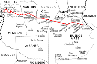
Buenos Aires, officially the Buenos Aires Province, is the largest and most populous Argentine province. It takes its name from the city of Buenos Aires, the capital of the country, which used to be part of the province and the province's capital until it was federalized in 1880. Since then, in spite of bearing the same name, the province does not include Buenos Aires proper, though it does include all other parts of the Greater Buenos Aires metropolitan area. The capital of the province is the city of La Plata, founded in 1882.

<span class="mw-page-title-main">Greater Buenos Aires</span> Place in Argentina

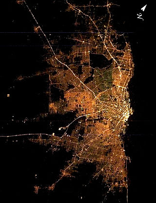
Greater Buenos Aires, also known as the Buenos Aires Metropolitan Area, refers to the urban agglomeration comprising the Autonomous City of Buenos Aires and the adjacent 24 partidos (districts) in the Province of Buenos Aires. Thus, it does not constitute a single administrative unit. The conurbation spreads south, west and north of Buenos Aires city. To the east, the River Plate serves as a natural boundary.

<span class="mw-page-title-main">Moreno, Buenos Aires</span> City in Buenos Aires, Argentina

Moreno is a city in Buenos Aires Province, Argentina. It is the head town of Moreno Partido. It forms part of the Greater Buenos Aires urban conurbation and is located around 36 km (22 mi) to the west of the autonomous city of Buenos Aires.

<span class="mw-page-title-main">Ituzaingó Partido</span> Department in Argentina

Ituzaingó is a partido of Buenos Aires Province. It is in the Gran Buenos Aires urban area, Argentina, 10 kilometres (6.2 mi) west of Buenos Aires city. It has an area of 38.51 km2 (14.9 sq mi) and a population of 168,419. Its capital, the city of Ituzaingó, and the other districts in Ituzaingó Partido were part of the Morón Partido until 1995.

<span class="mw-page-title-main">Partidos of Buenos Aires</span> Administrative territorial entity of Buenos Aires Province, Argentina

A partido is the second-level administrative subdivision only in the province of Buenos Aires, Argentina. They are formally considered to be a single administrative unit, usually contain one or more population centers, and are divided into localidades. The subdivision in partidos in Buenos Aires Province is distinct from all other provinces of Argentina, which call their second-level subdivisions departamento and are further subdivided into distinct municipalities.

<span class="mw-page-title-main">Morón, Buenos Aires</span> City in Buenos Aires, Argentina

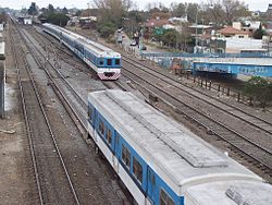
Morón is a city in the Argentine province of Buenos Aires, capital of the Morón partido, located in the Greater Buenos Aires metropolitan area, at 34°39′S58°37′W. Located 20 km (13 mi) west of Downtown Buenos Aires, Morón is easily reached via bus along Avenida Rivadavia, via National Highway 7, and the Sarmiento railway line.

<span class="mw-page-title-main">National Route 9 (Argentina)</span> Highway in Argentina

National Route 9 is a major road in Argentina, which runs from the center-east to the northwest of the country, crossing the provinces of Buenos Aires, Santa Fe, Córdoba, Santiago del Estero, Tucumán, Salta and Jujuy. It starts on Avenida General Paz, which marks the border between the Autonomous City of Buenos Aires and the surrounding province of the same name, and ends at the Horacio Guzmán International Bridge, on the La Quiaca River, traversing 1,967 km (1,222 mi). The road is a limited access motorway from Buenos Aires to Rosario.

<span class="mw-page-title-main">Tres de Febrero Partido</span> Partido in Buenos Aires Province, Argentina

Tres de Febrero is a partido of the Greater Buenos Aires conurbation area in the Buenos Aires Province, Argentina.

<span class="mw-page-title-main">Merlo, Buenos Aires</span> City in Buenos Aires, Argentina

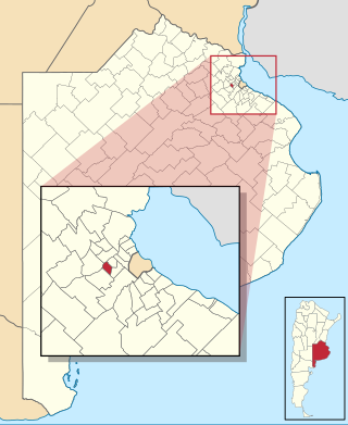
Merlo is the head town of the eponymous partido of Merlo and seat of the municipal government, located in the Greater Buenos Aires urban area of Buenos Aires Province, Argentina.

<span class="mw-page-title-main">San Antonio de Padua</span> City in Buenos Aires, Argentina

San Antonio de Padua, or plainly Padua, is a city in the Greater Buenos Aires, in Argentina. It is located in Merlo Partido. The city has an area of 6.25 km2 (2 sq mi) and a population of around 38,000.

<span class="mw-page-title-main">Parque San Martín, Buenos Aires</span> City in Buenos Aires, Argentina

Parque San Martín is a city located in Merlo Partido, Buenos Aires Province, Argentina. Parque San Martín was founded around 1948 by real estate promoters, in the estates belonging to the Etcheverry family. Like many others places in Argentina, the city was named after the Argentine independence hero General José de San Martín.

<span class="mw-page-title-main">National Route 7 (Argentina)</span> Highway in Argentina

National Route 7 is a road in Argentina. It crosses the country from east to west, from the capital to the border with Chile, thus linking the Atlantic coast with the Andes, crossing the provinces of Buenos Aires, Santa Fe, Córdoba, San Luis and Mendoza. It has a total length of 1,224 km (761 mi), of which 367 km (228 mi) (30%) are freeways.

There are a number of major football rivalries in Argentina.

Libertad is a city located in Merlo Partido, Buenos Aires Province, Argentina. It forms part of the Greater Buenos Aires urban conurbation.

<span class="mw-page-title-main">Mariano Acosta, Buenos Aires</span> City in Buenos Aires, Argentina

Mariano Acosta is a city located in Merlo Partido, Buenos Aires Province, Argentina. Mariano Acosta was founded by the landholder and businessman Juan Posse in the earliest 20th century, and for years the town was known as Villa (village) Posse. Villa Posse changed its name to Mariano Acosta when the British-owned railway company Buenos Aires Western Railway Co. opens a railway station at its surroundings in 1910. The station was named after Mariano Acosta (1825-1893), Argentine lawyer and politician, former Vice-President of Argentina and governor of Buenos Aires.

<span class="mw-page-title-main">Veinte de Junio</span> Place in Buenos Aires, Argentina

Veinte de Junio is a town located 35 km from Buenos Aires, in La Matanza, Buenos Aires Province, Argentina.

<span class="mw-page-title-main">Paso del Rey</span> City in Buenos Aires, Argentina

Paso del Rey is a city located 35.5 km west of Buenos Aires, in Moreno, Buenos Aires Province, Argentina.

<span class="mw-page-title-main">Avenida Rivadavia</span> Street in Buenos Aires, Argentina

Avenida Rivadavia is one of the principal thoroughfares in Buenos Aires, Argentina, extending 23 miles (37 km) from downtown Buenos Aires to the western suburb of Merlo.

<span class="mw-page-title-main">Club Atlético San Antonio de Padua</span> Rugby team

Club Atlético San Antonio de Padua, familiarly known as CASA de Padua, is an Argentine sports club located in the city of San Antonio de Padua, Buenos Aires Province. Although CASA is mostly known for its rugby union team, the club hosts the practise of other sports and activities such as basketball, field hockey, swimming, pilates and yoga.

References

  1. "2010 Census provisional results". Archived from the original on 2012-09-01. Retrieved 2011-03-07.
  2. Thomas Falkner (Manchester, October 6, 1702 – January 30, 1784) was an English Jesuit, surgeon, ethnologist, botanist and zoologist. In 1774 Falkner published a book under the title "A Description of Patagonia and the adjoining parts of South America, with a grammar and a short vocabulary, and some particulars relating to Falkland's Islands".
  3. Florian Paucke (or Baucke), (Wińsko, Wołów County, Lower Silesia, September 24, 1719 - Zwettl Abbey, April 13, 1780). He was a Jesuit priest, ethnologist, botanist and zoologist.
  4. Dictionary of Irish Latin American Biography
  5. Provincial Statistics Office Archived 2007-06-13 at the Wayback Machine
  6. 1866 Provincial Census.
  7. National Census: 1869, 1895, 1914, 1947, 1960, 1970, 1980, 1991 and 2001.
  8. Provincial Statistics Office: Demographic projections for Buenos Aires, 2007. [ permanent dead link ]
  9. INDEC Archived 2008-01-09 at the Wayback Machine
  10. Provincial Statistics Office Archived 2007-06-14 at the Wayback Machine

Further reading