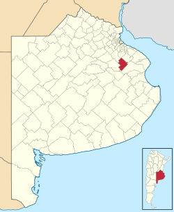
General Paz Partido de General Paz | |
---|---|
Coordinates: 35°32′S58°17′W / 35.533°S 58.283°W | |
Country | Argentina |
Established | October 25, 1864 |
Founded by | provincial law 422 |
Seat | Ranchos |
Government | |
• Mayor | Edgardo Juan Uribarri (PJ) |
Area | |
• Total | 1,197 km2 (462 sq mi) |
Population | |
• Total | 10,319 |
• Density | 8.6/km2 (22/sq mi) |
Demonym(s) | pacense |
Postal Code | B1987 |
IFAM | |
Area Code | 02241 |
Website | municipalidaddegeneralpaz |
General Paz Partido is a partido in the northeast of Buenos Aires Province in Argentina.
The provincial subdivision has a population of about 10,000 inhabitants in an area of 1,197 km2 (462 sq mi), and its capital city is Ranchos, which is 110 km (68 mi) from Buenos Aires.
The partido is named in honour of Brigadier General José María Paz, a veteran of the Argentine War of Independence.
Buenos Aires, officially the Buenos Aires Province, is the largest and most populous Argentine province. It takes its name from the city of Buenos Aires, the capital of the country, which used to be part of the province and the province's capital until it was federalized in 1880. Since then, in spite of bearing the same name, the province does not include Buenos Aires proper, though it does include all other parts of the Greater Buenos Aires metropolitan area. The capital of the province is the city of La Plata, founded in 1882.
A partido is the second-level administrative subdivision only in the province of Buenos Aires, Argentina. They are formally considered to be a single administrative unit, usually contain one or more population centers, and are divided into localidades. The subdivision in partidos in Buenos Aires Province is distinct from all other provinces of Argentina, which call their second-level subdivisions departamento and are further subdivided into distinct municipalities.
Ruta Nacional 3 is an Argentine highway, stretching from the eastern side of the country in Buenos Aires, crossing the provinces of Buenos Aires, Río Negro, Chubut Province, Santa Cruz and Tierra del Fuego. Since its start at Avenida General Paz (A001) until the end, on the bridge over Lapataia River, it measures 3,045 kilometres (1,892 mi).
Marcos Paz is a partido in the Argentine province of Buenos Aires. Its capital city is Marcos Paz.
Laprida Partido is a partido in central Buenos Aires Province in Argentina.
Benito Juárez is a partido in the south-central part of Buenos Aires Province in Argentina.
The Partido de Lincoln is a partido of Buenos Aires Province in Argentina. It is located in the northwestern part of the province, in central Argentina.
Adolfo Gonzales Chaves is a partido of Buenos Aires Province in Argentina, it is located at coordinates 38°02′S60°05′W.
The partido of Coronel Suárez is a subdivision of the Province of Buenos Aires in Argentina. In the south-central part of the province, it was created in 1882 by the provincial government when they divided the territory of Tres Arroyos into the partidos of Coronel Suárez, Tres Arroyos and Coronel Pringles.
Dolores Partido is a partido in the eastern part of Buenos Aires Province in Argentina. It borders the partidos of Castelli, Tordillo, Maipú, General Guido and Pila.
General Alvarado Partido is a partido on the Atlantic Coast of Buenos Aires Province in Argentina.
General Belgrano Partido is a partido east of Buenos Aires Province in Argentina.
General Las Heras Partido is a small partido in the northeast of Buenos Aires Province in Argentina.
General Villegas Partido is the northeasternmost partido of Buenos Aires Province in Argentina.
José C. Paz Partido is a partido in the Greater Buenos Aires urban area of Buenos Aires Province in Argentina.
Leandro N. Alem Partido is a partido in the north of Buenos Aires Province in Argentina.
Mercedes Partido is a partido in the eastern part of Buenos Aires Province in Argentina.
Monte Partido is a partido in the eastern part of Buenos Aires Province in Argentina.
Monte Hermoso Partido is a partido on the Atlantic coast of Buenos Aires Province in Argentina.
National Route 12 (RN12) is a road in Argentina, connecting the northeast section to the rest of the country. It runs through the provinces of Misiones, Corrientes, Entre Ríos and Buenos Aires.