Monte Partido

Last updated
Monte
Partido de San Miguel del Monte
Monte municipio logo.png
Argentina - Buenos Aires - San Miguel del Monte.svg
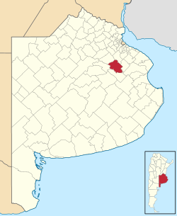
location of Partido de San Miguel del Monte in Buenos Aires Province
Coordinates: 35°27′S58°47′W / 35.450°S 58.783°W / -35.450; -58.783
Country Argentina
EstablishedNovember 18, 1779
Founded by Virrey Vértiz
Seat Monte
Government
  MayorRogelio Andrés Bernardes (PJ)
Area
  Total1,847 km2 (713 sq mi)
Population
  Total17,488
  Density9.5/km2 (25/sq mi)
Demonym montense
Postal Code
B7220
IFAM
Area Code02271
Website www.monte.gov.ar

Monte Partido (also known as San Miguel del Monte) is a partido in the eastern part of Buenos Aires Province in Argentina.

Contents

The provincial subdivision has a population of about 17,500 inhabitants in an area of 1,847 km2 (713 sq mi), and its capital city is Monte, 110 km (68 mi) from Buenos Aires on the banks of the Salado River.

Geography

The northwest course of the Salado borders with the Partidos of Roque Pérez and General Belgrano. Monte lies in the Humid Pampa, a flat rich-soiled agricultural zone. Drainage is insufficient due to the minimal sloping of the land which causes frequent floods in the area.

Climate

Monte has a temperate climate, with average temperatures of 17 °C (63 °F). The median temperature of the warmest month is 25 °C (77 °F) and the coldest is 10 °C (50 °F). Annual precipitation is 1,000 mm (39.4 in).

Borders

Settlements

Tourism

Fishing and water sports

Ranches

Related Research Articles

<span class="mw-page-title-main">Lobos</span> City in Buenos Aires, Argentina

Lobos is the headquarters city of the Lobos Partido in Buenos Aires Province, Argentina. It was founded on 2 June 1802 by José Salgado.

<span class="mw-page-title-main">Buenos Aires Province</span> Province of Argentina

Buenos Aires, officially the Buenos Aires Province, is the largest and most populous Argentine province. It takes its name from the city of Buenos Aires, the capital of the country, which used to be part of the province and the province's capital until it was federalized in 1880. Since then, in spite of bearing the same name, the province does not include Buenos Aires city, though it does include all other parts of the Greater Buenos Aires metropolitan area. The capital of the province is the city of La Plata, founded in 1882.

<span class="mw-page-title-main">San Miguel de Tucumán</span> City in Tucumán, Argentina

San Miguel de Tucumán, usually called simply Tucumán, is the capital and largest city of Tucumán Province, located in northern Argentina 1,311 kilometres (815 mi) from Buenos Aires. It is the fifth-largest city of Argentina after Buenos Aires, Córdoba, Rosario and Mendoza and the most important of the northern region. The Spanish conquistador Diego de Villarroel founded the city in 1565 in the course of an expedition from present-day Peru. Tucumán moved to its present site in 1685.

<span class="mw-page-title-main">Mercedes, Buenos Aires</span> City in Buenos Aires, Argentina

Mercedes is a city in Buenos Aires Province, Argentina. It is located 100 km west from Buenos Aires and 30 km southwest of Luján. It is the administrative headquarters for the district (partido) of Mercedes as well as of the judicial district. The Catedral Basílica de Mercedes-Luján, located in the city, is the seat of the Roman Catholic Archdiocese of Mercedes-Luján.

<span class="mw-page-title-main">Greater Buenos Aires</span> Urban agglomeration in Argentina

Greater Buenos Aires, also known as the Buenos Aires Metropolitan Area, refers to the urban agglomeration comprising the Autonomous City of Buenos Aires and the adjacent 24 partidos (districts) in the Province of Buenos Aires. Thus, it does not constitute a single administrative unit. The conurbation spreads south, west and north of Buenos Aires city. To the east, the River Plate serves as a natural boundary.

<span class="mw-page-title-main">Olivos, Buenos Aires</span> District in Buenos Aires, Argentina

Olivos is a neighborhood in Vicente López Partido, Buenos Aires Province, Argentina. It is bordered to the south by Vicente López neighborhood and Florida; to the east by the River Plate; to the north by La Lucila and Martínez, and to the west by Munro.

<span class="mw-page-title-main">Partidos of Buenos Aires</span> Administrative territorial entity of Buenos Aires Province, Argentina

A partido is the second-level administrative subdivision only in the province of Buenos Aires, Argentina. They are formally considered to be a single administrative unit, usually contain one or more population centers, and are divided into localidades. The subdivision in partidos in Buenos Aires Province is distinct from all other provinces of Argentina, which call their second-level subdivisions departamento and are further subdivided into distinct municipalities.

<span class="mw-page-title-main">Index of Argentina-related articles</span>

The following is an alphabetical list of topics related to the Argentina.

<span class="mw-page-title-main">National Route 3 (Argentina)</span> Highway in Argentina

Ruta Nacional 3 is an Argentine highway, stretching from the eastern side of the country in Buenos Aires, crossing the provinces of Buenos Aires, Río Negro, Chubut Province, Santa Cruz and Tierra del Fuego. Since its start at Avenida General Paz (A001) until the end, on the bridge over Lapataia River, it measures 3,045 kilometres (1,892 mi).

<span class="mw-page-title-main">Salado River (Buenos Aires)</span>

The Salado River is a river in northern Buenos Aires Province, Argentina. It originates at El Chañar Lake on the boundary with Santa Fe Province, 40 metres (130 ft) above mean sea level, and flows generally southeast for 640 kilometres (400 mi) before debouching into Samborombón Bay, part of the Río de la Plata estuary on the Atlantic Ocean. The Salado's mouth is about 170 kilometres (110 mi) south of the city of Buenos Aires.

<span class="mw-page-title-main">Laprida Partido</span> Department in Argentina

Laprida Partido is a partido in central Buenos Aires Province in Argentina.

<span class="mw-page-title-main">Dolores Partido</span> Department in Argentina

Dolores Partido is a partido in the eastern part of Buenos Aires Province in Argentina. It borders the partidos of Castelli, Tordillo, Maipú, General Guido and Pila.

<span class="mw-page-title-main">General Paz Partido</span> Department in Argentina

General Paz Partido is a partido in the northeast of Buenos Aires Province in Argentina.

<span class="mw-page-title-main">Mercedes Partido</span> Department in Argentina

Mercedes Partido is a partido in the eastern part of Buenos Aires Province in Argentina.

<span class="mw-page-title-main">Monte Hermoso Partido</span> Department in Argentina

Monte Hermoso Partido is a partido on the Atlantic coast of Buenos Aires Province in Argentina.

<span class="mw-page-title-main">Roque Pérez Partido</span> Department in Argentina

Roque Peréz Partido is a partido of Buenos Aires Province in Argentina.

<span class="mw-page-title-main">Suipacha Partido</span> Department in Argentina

Suipacha Partido is a partido of Buenos Aires Province in Argentina.

<span class="mw-page-title-main">Sierra de las Quijadas National Park</span> National park in San Luis, Argentina

The Sierra de las Quijadas National Park is a national park located in the northwestern part of the Argentine province of San Luis. It was established on December 10, 1991, to protect the natural features, representative of the Semiarid Chaco and the High Monte ecoregions.

<span class="mw-page-title-main">Córdoba Province, Argentina</span> Province of Argentina

Córdoba is a province of Argentina, located in the center of the country. Its neighboring provinces are Santiago del Estero, Santa Fe, Buenos Aires, La Pampa, San Luis, La Rioja, and Catamarca. Together with Santa Fe and Entre Ríos, the province is part of the economic and political association known as the Center Region.