
The Wurundjeripeople are an Australian Aboriginal people of the Woiwurrung language group, in the Kulin nation. They are the Traditional Owners of the Birrarung Valley, covering much of the present location of Narrm (Melbourne). They continue to live in this area and throughout Australia. They were called the Yarra tribe by early European colonists.
Officer South is a suburb and rural locality in Melbourne, Victoria, Australia, 50 km (31 mi) south-east of Melbourne's Central Business District, located within the Shire of Cardinia local government area. Officer South recorded a population of 1,159 at the 2021 census.
Pakenham Upper is a rural locality in Melbourne, Victoria, Australia, 53 km (33 mi) south-east of Melbourne's Central Business District, located within the Shire of Cardinia local government area. Pakenham Upper recorded a population of 1,196 at the 2021 census.
Pakenham South is a suburb and rural locality in Melbourne, Victoria, Australia, 59 km (37 mi) south-east of Melbourne's Central Business District, located within the Shire of Cardinia local government area. Pakenham South recorded a population of 229 at the 2021 census.

The Kulin nation is an alliance of five Indigenous Australian nations in south central Victoria, Australia. Their collective territory extends around Port Phillip and Western Port, up into the Great Dividing Range and the Loddon and Goulburn River valleys.

Tarneit is a suburb in Melbourne, Victoria, Australia, 25 km (16 mi) west of Melbourne's Central Business District, located within the City of Wyndham local government area. Tarneit recorded a population of 56,370 at the 2021 census.
Nar Nar Goon is a town in Gippsland, Victoria, Australia, 61 km south-east of Melbourne's Central Business District, located within the Shire of Cardinia local government area. Nar Nar Goon recorded a population of 1,023 at the 2021 census.
The Boonwurrungpeople, are an Aboriginal people of the Kulin nation, who are the Traditional Owners of the land from the Werribee River to Wilsons Promontory, Victoria, Australia. Their territory includes part of what is now the city and suburbs of Melbourne. Before British colonisation, they lived as all people of the Kulin nation lived, sustainably on the land, for tens of thousands of years. They were called the Western Port or Port Philip tribe by the early settlers, and were in alliance with other tribes in the Kulin nation, having particularly strong ties to the Wurundjeri people.

The Werribee River is a perennial river of the Port Phillip catchment that is located on the expansive lowland plain southwest of Melbourne, Victoria, Australia. The headwaters of a tributary, the Lerderderg River, are north of Ballan near Daylesford and it flows across the basalt plain, through the suburb of Werribee to enter Port Phillip. A linear park follows the Werribee River along much of its course. In total the Werribee River completes a journey of approximately 110 kilometres (68 mi).
The Taungurung people, also spelt Daung Wurrung, consisted of nine clans who spoke the Taungurung language and were part of the Kulin alliance of indigenous Australians. They lived to the north of, and were closely associated with, the Woiwurrung speaking Wurundjeri people. Their territory is to the north of the Great Dividing Range in the watersheds of the Broken, Delatite, Coliban, Goulburn and Campaspe Rivers. They were also known by white settlers as the Devil's River Tribe or Goulburn River Tribe.
Woiwurrung and Taungurung are Aboriginal languages of the Kulin Nation of Central Victoria. Woiwurrung was spoken by the Woiwurrung and related peoples in the Yarra River (Birrarung) basin, and Taungurung by the Taungurung people north of the Great Dividing Range in the Goulburn River Valley around Mansfield, Benalla and Heathcote. They are often portrayed as distinct languages, but they were mutually intelligible. Ngurai-illamwurrung (Ngurraiillam) may have been a clan name, a dialect, or a closely related language.
Plumpton is a suburb in Melbourne, Victoria, Australia, 30 km (19 mi) north-west of Melbourne's Central Business District, located within the City of Melton local government area. Plumpton recorded a population of 79 at the 2021 census.
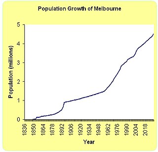
Melbourne is Australia's second largest city and has a diverse and multicultural population.
The Boonwurrung language, also anglicised as Bunurong, Bun wurrung, and other variant spellings, is an Aboriginal Australian language traditionally spoken by the Boonwurrung people of the Kulin nation of central Victoria prior to European settlement in the colony of Victoria. The last remaining traditional native speakers died in the early 20th century; however there is an active revival movement under way in the Boonwurrung community.
Wadawurrung, also rendered as Wathawurrung, Wathaurong or Wada wurrung, and formerly sometimes Barrabool, is the Aboriginal Australian language spoken by the Wathaurong people of the Kulin Nation of Central Victoria. It was spoken by 15 clans south of the Werribee River and the Bellarine Peninsula to Streatham.
The Woiwurrung, also spelt Woi Wurrung, Woiwurrong, Woiworung, Wuywurung, are an Aboriginal Australian people of the Woiwurrung language group, in the Kulin alliance.

Cobblebank is a suburb in Melbourne, Victoria, Australia, 33 km (21 mi) west of Melbourne's Central Business District, located within the City of Melton local government area. Cobblebank recorded a population of 3,601 at the 2021 census.
Mount Atkinson is a suburb in Melbourne, Victoria, Australia, 23 km (14 mi) west of Melbourne's Central Business District, located within the City of Melton local government area.

The Western Rail Plan is a metropolitan rail infrastructure project being planned in Melbourne, Australia. The project was initially announced during the 2018 Victorian State Election by the State Government. It includes the electrification of two currently existing regional lines to Melton and Wyndham Vale, as well as Fast Rail to Geelong, and other network capacity upgrades. The project will allow for much higher capacity on the Western Corridor. The electrification to Melton is part of Stage 3 of the PTV Network Development Plan. $100 million is being invested in detailed planning and design work, to deliver the full separation of regional and metro services on the Geelong and Ballarat lines. Staging of the works part of the plan are being done alongside the business case for the Melbourne Airport Rail Link.
Pakenham East is a suburb of the Greater Melbourne metropolitan area situated south-east of Melbourne City. Pakenham East is located in the Shire of Cardinia local government area.
