
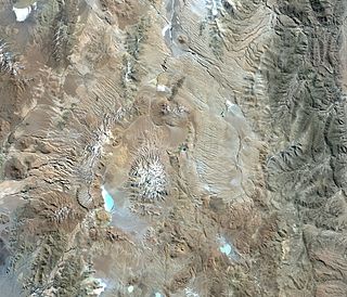
Emi Koussi is a high pyroclastic shield volcano that lies at the southeast end of the Tibesti Mountains in the central Sahara, in the northern Borkou Region of northern Chad. The highest mountain of the Sahara, the volcano is one of several in the Tibesti range, and reaches an elevation of 3,415 metres (11,204 ft), rising 3 km (1.9 mi) above the surrounding sandstone plains. The volcano is 60–70 kilometres (37–43 mi) wide and has a volume of 2,500 cubic kilometres (600 cu mi).

Falso Azufre is a complex volcano at the border of Argentina and Chile.

Toussidé is a potentially active stratovolcano in Chad. Toussidé lies in the Tibesti Mountains, the large Yirrigué caldera and the smaller Trou au Natron and Doon Kidimi craters are close to it. It has an elevation of 3,265 m (10,712 ft) above sea level. The volcano is the source of a number of lava flows, which have flowed westward away from Toussidé and east into the Yirrigué caldera.

Mount Hasan is a volcano in Anatolia, Turkey. It has two summits, the 3,069 metres (10,069 ft) high eastern Small Hasan Dagi and the 3,253 metres (10,673 ft) high Big Hasan Dagi, and rises about 1 kilometre (0.62 mi) above the surrounding terrain. It consists of various volcanic deposits, including several calderas, and its activity has been related to the presence of several faults in the area and to regional tectonics.
Cerro Galán is a caldera in the Catamarca Province of Argentina. It is one of the largest exposed calderas in the world and forms part of the Central Volcanic Zone of the Andes, one of the three volcanic belts found in South America. One of several major caldera systems in the Central Volcanic Zone, the mountain is grouped into the Altiplano–Puna volcanic complex.
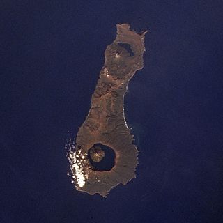
Nemo Peak is a stratovolcano located at the northern end of Onekotan Island, Kuril Islands, Russia. It is truncated by two nested calderas, with the cone of Nemo Peak itself rising in the southwest end of the youngest caldera and a crater lake partially filling the northeast part, named Ozero Chernoye.
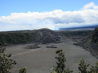
Kīlauea Iki is a pit crater that is next to the main summit caldera of Kīlauea on the island of Hawaiʻi in the Hawaiian Islands. It is known for its eruption in 1959 that started on November 14 and ended on December 20, producing lava fountaining up to 1900 feet and a lava lake in the crater. Today, the surface of the lava lake has cooled and it is now a popular hiking destination to view the aftermath of an eruption.

Tarso Toh is a volcanic field located in Chad, north of Tarso Toussidé volcano. It fills valleys and plains over an area of 80 km in east–west direction and 20–30 km in north–south direction. It contains 150 scoria cones and two maars.

James Healy Seamount is a submarine volcano located among the South Kermadec Ridge Seamounts south of New Zealand's Kermadec Islands. It consists of a volcanic cone that reaches a depth of 1,150 metres (3,770 ft) below sea level, two 2–2.5 kilometres (1.2–1.6 mi) and 1.3 kilometres (0.81 mi) wide calderas and a parasitic cone that reaches a depth of 950 metres (3,120 ft) below sea level. The flanks of the volcano are covered with pumice and volcanic rocks, and hydrothermal venting occurs inside the caldera.

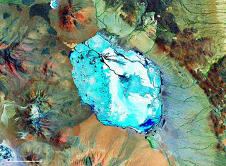
Lake Pinatubo is the summit crater lake of Mount Pinatubo formed after its climactic eruption on June 15, 1991. The lake is located in Botolan, Zambales, near the boundaries of Pampanga and Tarlac provinces in the Philippines. It is about 90 km (56 mi) northwest of the capital city of Manila. While one paper by researchers from Japan suggested a depth of 600 m (2,000 ft), more detailed research suggests that 95–115 m (312–377 ft) is more accurate.

Hualca Hualca is an extinct volcano in Arequipa Region in the Andes of Peru. It has a height of 6,025 metres (19,767 ft). It is located at the Peruvian province of Caylloma.

La Pacana is a Miocene age caldera in northern Chile's Antofagasta Region. Part of the Central Volcanic Zone of the Andes, it is part of the Altiplano-Puna volcanic complex, a major caldera and silicic ignimbrite volcanic field. This volcanic field is located in remote regions at the Zapaleri tripoint between Chile, Bolivia and Argentina.

Solimana is a volcanic massif in the Andes of Peru, South America, that is approximately 6,093 metres (19,990 ft) high. It is considered an extinct stratovolcano that is part of the Central Volcanic Zone, one of the volcanic belts of the Andes. It features a caldera as well as traces of a sector collapse and subsequent erosion. The volcano is glaciated.
Aguas Calientes is a major Miocene caldera in Salta Province, Argentina. It is in the Central Volcanic Zone of the Andes, a zone of volcanism covering southern Peru, Bolivia, northwest Argentina and northern Chile. This zone contains stratovolcanoes and calderas.
Pastos Grandes is the name of a caldera and its crater lake in Bolivia. The caldera is part of the Altiplano-Puna volcanic complex, a large ignimbrite province that is part of the Central Volcanic Zone of the Andes. Pastos Grandes has erupted a number of ignimbrites through its history, some of which exceeded a volume of 1,000 cubic kilometres (240 cu mi). After the ignimbrite phase, the lava domes of the Cerro Chascon-Runtu Jarita complex were erupted close to the caldera and along faults.

Tutupaca is a volcano in the region of Tacna in Peru. It is part of the Peruvian segment of the Central Volcanic Zone, one of several volcanic belts in the Andes. Tutupaca consists of three overlapping volcanoes formed by lava flows and lava domes made out of andesite and dacite, which grew on top of older volcanic rocks. The highest of these is usually reported to be 5,815 metres (19,078 ft) tall and was glaciated in the past.

Tarso Yega is a stratovolcano in Tibesti, with a summit caldera that is 19 by 20 kilometres wide and 300 metres (980 ft) deep. The summit of the volcano reaches a height of 2,972 metres (9,751 ft), and its caldera is the largest caldera of the Tibesti. Neighbouring volcanoes include Doudriki east, Ehi Dosoatou south and Ehi Fodoboro southwest of the caldera. The Enneri Yega river drains the caldera westward and then south, before joining the Enneri Debarsar; in the past (Holocene) the rivers reached Lake Chad and lakes formed in Tarso Yega.
Tarso Emi Chi is a volcano in Chad.
Tarso Ahon is a Pleistocene volcano in Tibesti, north of Emi Koussi from which it is separated by deep gorges. It covers a surface of about 50 by 60 kilometres and is a so-called volcanic plateau with three summits: Arken Ahon, Dondomé, Tarso Ahon and Tarso Mohi. However, contrary to its plateau-like appearance the basaltic surfaces of Tarso Ahon are difficult to access and steep. Tarso Ahon has erupted andesite, rhyolite and similar magmas, and more recently basalts which form lava flows.

Ubinas is an active stratovolcano in the Moquegua Region of southern Peru, approximately 60 kilometres (37 mi) east of the city of Arequipa. Part of the Central Volcanic Zone of the Andes, it rises 5,672 metres (18,609 ft) above sea level. The volcano's summit is cut by a 1.4-kilometre-wide (0.87 mi) and 150-metre-deep (490 ft) caldera, which itself contains a smaller crater. Below the summit, Ubinas has the shape of an upwards-steepening cone with a prominent notch on the southern side. The gently sloping lower part of the volcano is also known as Ubinas I and the steeper upper part as Ubinas II; they represent different stages in the volcano's geological history.

