
The Province of Teramo is a province in the Abruzzo region of Italy. Its capital is the city of Teramo. The province has an area of 1,948 square kilometres (752 sq mi), a population of 313,029 (2012), and is subdivided into 47 comunes, see Comunes of the Province of Teramo. The Province of Teramo shares its northern border with the Province of Ascoli Piceno in the Marche Region, southern and southwestern borders with the Province of L'Aquila in the Abruzzo Region, and a western border with the Province of Rieti in the Region of Lazio. To the south is the Abruzzo Province of Pescara and to the east is the Adriatic Sea.

Faieto is a suburb (frazione) of the nearby communal city, Cortino, in the Italian Province of Teramo. It lies at an altitude of about 2070 feet above sea level.

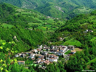
Montorio al Vomano is a town and comune in the province of Teramo, in the Abruzzo region of central-southern Italy. It is located in the natural park known as the Gran Sasso e Monti della Laga National Park.

Calascio is a comune and village in the province of L'Aquila, in the Abruzzo region of central Italy. It is located in the Gran Sasso e Monti della Laga National Park.

Santo Stefano di Sessanio is a comune and hill town in the province of L'Aquila in the Abruzzo region of southern Italy. Located in the Gran Sasso e Monti della Laga National Park, in the highest region of the Apennines, this medieval hill town sits adjacent to the high plain of Campo Imperatore.

Crognaleto is a comune and city of slightly less than 2,000 people in the Province of Teramo, central Italy. Crognaleto sits at an elevation of 1,105 metres (3,625 ft) and has its communal administrative offices in the frazione of Nerito. The commune of Crognaleto sits on the slopes of the Monti della Laga mountain range and extends across both the northern and the southern slopes of the Vomano Valley. It lies within the Gran Sasso e Monti della Laga National Park.

Rocca Santa Maria is a town and comune in the province of Teramo, Abruzzo, eastern Italy. It is located in the Gran Sasso e Monti della Laga National Park. The municipal seat is in the frazione of Imposte.
Valle Castellana is a village and comune in the Province of Teramo, in the Abruzzo region of central Italy. It is a member of the Italian community of surrounding mountain villages, Monti della Laga. It is located in the natural park known as the Gran Sasso e Monti della Laga National Park.

Padula is a small village in the Province of Teramo, in the Abruzzo region of central Italy. It is a hamlet (frazione) of the commune of Cortino.

Valle Piola is a deserted village in the province of Teramo, in the Abruzzo region of central Italy. It is a frazione of the comune of Torricella Sicura. Having been abandoned in 1977, all that remains are 9 abandoned houses, a church, and the ruins of a shepherds' shelter. The village has recently received renewed interest from the Gran Sasso and Monti della Laga National Park authorities with the aim of restoring and revitalizing the village and its environs.

The Gran Sasso and Monti della Laga National Park is a natural park located mostly in Abruzzo, Italy. It was established in 1991, it has an area of 2,014 square kilometres (778 sq mi), and it is mainly spread out across the province of Teramo, L'Aquila, Pescara, with small areas in the province of Rieti and Ascoli Piceno. The terrain is predominantly mountainous with alpine plains.
San Giacomo is a mountain village in the Province of Teramo in the Abruzzo region of Italy. It is a frazione of the comune of Valle Castellana.

Valle Pezzata is a village in the Abruzzo region of central Italy. It is a frazione of the comune of Valle Castellana. The village lies in an area known as Monti della Laga, deep within the Gran Sasso e Monti della Laga National Park.
Martese is a "frazione" (hamlet) in the commune of Rocca Santa Maria in the Province of Teramo, Italy.
Magliano is a village in the Italian region of Abruzzo. It is a frazione of the comune of Torricella Sicura, in the Province of Teramo.
Serra is an Italian village and frazione of the Commune of Rocca Santa Maria in the Province of Teramo, Abruzzo, Italy. The village sits at an elevation of 3596 feet above sea level in the area of Monti della Laga within the Gran Sasso e Monti della Laga National Park.
Figliola is a frazione of the comune of Crognaleto, in the Province of Teramo within the Abruzzo Region of Italy. It is between the towns of Crognaleto, San Giorgio and Aiello in the Vomano Valley. Figliola faces the Gran Sasso and can be reached via a road that is partially paved.

Frunti or Fronto was an ancient territorial and administrative jurisdiction located in the central part of Italy. The name Frunti exists to this day as a specific geographical location, although in Medieval times the name referred to a larger, more expansive area of land. Frunti is located southwest of Teramo.

Tourism in Abruzzo has become one of the most prosperous sectors in the economy of Abruzzo, and in recent years has seen a remarkable growth attracting numerous tourists from Italy and Europe. According to statistics from the Italian institute of statistics (ISTAT), in 2007 arrivals totaled 1,371,155 Italians and 189,651 foreigners. A total of 7,374,646 arrivals were tourists, a figure that puts the region seventeenth among the Italian regions for numbers of tourists per year. According to market analysis and sector studies on tourism in the Abruzzo National Society TurisMonitor 2012, after an increase that was estimated at between 4 and 5% of international tourist arrivals in the Abruzzo region in 2012 was estimated to increase that international arrivals will be around 3/4% by the end of 2012 with staff working in tourism will increase settling at about 25,000 people. Always position first-arrivals from Germany. A moderate support to tourism is also given to the Abruzzo Airport with many low cost and charter flights connecting the entire region with the rest of Europe. Abruzzo tourism can basically be divided into three different types: mountain tourism hiking natural which includes numerous ski resorts, nature reserves and protected areas, beach tourism and coastal with the number of resort, hotel, camping and beaches, and finally the art-historical tourism religious and cultural concentrated mostly in mountain villages and historic towns such as l'Aquila, Vasto, Chieti, Teramo, Sulmona and many others.

Assergi is a frazione of the comune of L'Aquila, located about 11 km (6.8 mi) from the capital. With a population of just over 500, it is situated at an altitude of approximately 1,000 meters, below the western slope of the Gran Sasso in a small plain called the Piana di Assergi (Plain of Assergi). Assergi was formerly included in the comune of Camarda, which is directly to its south.

