Related Research Articles

The Old Red Sandstone is an assemblage of rocks in the North Atlantic region largely of Devonian age. It extends in the east across Great Britain, Ireland and Norway, and in the west along the eastern seaboard of North America. It also extends northwards into Greenland and Svalbard. These areas were a part of the ancient continent of Euramerica/Laurussia. In Britain it is a lithostratigraphic unit to which stratigraphers accord supergroup status and which is of considerable importance to early paleontology. For convenience the short version of the term, ORS is often used in literature on the subject. The term was coined to distinguish the sequence from the younger New Red Sandstone which also occurs widely throughout Britain.

In geology, a rift is a linear zone where the lithosphere is being pulled apart and is an example of extensional tectonics. Typical rift features are a central linear downfaulted depression, called a graben, or more commonly a half-graben with normal faulting and rift-flank uplifts mainly on one side. Where rifts remain above sea level they form a rift valley, which may be filled by water forming a rift lake. The axis of the rift area may contain volcanic rocks, and active volcanism is a part of many, but not all, active rift systems.

The state of Georgia is commonly divided into four geologic regions that influence the location of the state's four traditional physiographic regions. The four geologic regions include the Appalachian foreland, Blue Ridge, Piedmont, and Coastal Plain. These four geologic regions commonly share names with and typically overlap the four physiographic regions of the state: the Appalachian Plateau and adjacent Valley and Ridge; the Blue Ridge; the Piedmont and the Coastal Plain. The geologic regions of the state, established by geologists based on relationships between stratigraphic units, significantly influence the physiographic regional names used by physical geographers. Geologic regions of the state, however, do not perfectly coincide with physiographic regions of the state. Most geologic regions (terranes) in the state are separated from one another by major thrust faults that formed during the growth of the Appalachian Mountains. The Appalachian foreland, for example, is separated from the geologic Blue Ridge by the Talladega-Cartersville-Great Smoky fault. The geologic Blue Ridge is separated from the geologic Piedmont by the Brevard fault zone. The Fall Line, the surface expression of the Coastal Plain unconformity, is the geologic boundary between the Piedmont and the Coastal Plain.
The Newark Supergroup, also known as the Newark Group, is an assemblage of Upper Triassic and Lower Jurassic sedimentary and volcanic rocks which outcrop intermittently along the east coast of North America. They were deposited in a series of Triassic basins, the Eastern North American rift basins, approximately 220–190 million years ago. The basins are characterized as aborted rifts, with half-graben geometry, developing parallel to the main rift of the Atlantic Ocean which formed as North America began to separate from Africa. Exposures of the Newark Supergroup extend from South Carolina north to Nova Scotia. Related basins are also found underwater in the Bay of Fundy. The group is named for the city of Newark, New Jersey.
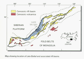
The Baikal Rift Zone is a series of continental rifts centered beneath Lake Baikal in southeastern Russia. Current strain in the rifts tends to be extending with some shear movement. A series of basins form along the zone for more than 2,000 kilometres (1,200 mi), creating a rift valley. The rifts form between the Eurasian Plate to the west and the Amur Plate to the east.

The Pyrenees are a 430-kilometre-long, roughly east–west striking, intracontinental mountain chain that divide France, Spain, and Andorra. The belt has an extended, polycyclic geological evolution dating back to the Precambrian. The chain's present configuration is due to the collision between the microcontinent Iberia and the southwestern promontory of the European Plate. The two continents were approaching each other since the onset of the Upper Cretaceous (Albian/Cenomanian) about 100 million years ago and were consequently colliding during the Paleogene (Eocene/Oligocene) 55 to 25 million years ago. After its uplift, the chain experienced intense erosion and isostatic readjustments. A cross-section through the chain shows an asymmetric flower-like structure with steeper dips on the French side. The Pyrenees are not solely the result of compressional forces, but also show an important sinistral shearing.

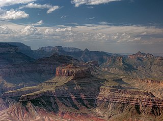
The Unkar Group is a sequence of strata of Proterozoic age that are subdivided into five geologic formations and exposed within the Grand Canyon, Arizona, Southwestern United States. The 5-unit Unkar Group is the basal member of the 8-member Grand Canyon Supergroup. The Unkar is about 1,600 to 2,200 m thick and composed, in ascending order, of the Bass Formation, Hakatai Shale, Shinumo Quartzite, Dox Formation, and Cardenas Basalt. Units 4 & 5 are found mostly in the eastern region of Grand Canyon. Units 1 through 3 are found in central Grand Canyon. The Unkar Group accumulated approximately between 1250 and 1104 Ma. In ascending order, the Unkar Group is overlain by the Nankoweap Formation, about 113 to 150 m thick; the Chuar Group, about 1,900 m (6,200 ft) thick; and the Sixtymile Formation, about 60 m (200 ft) thick. These are all of the units of the Grand Canyon Supergroup. The Unkar Group makes up approximately half of the thickness of the 8-unit Supergroup.
The Neoproterozoic Nankoweap Formation, is a thin sequence of distinctive red beds that consist of reddish brown and tan sandstones and subordinate siltstones and mudrocks that unconformably overlie basaltic lava flows of the Cardenas Basalt of the Unkar Group and underlie the sedimentary strata of the Galeros Formation of the Chuar Group. The Nankoweap Formation is slightly more than 100 m in thickness. It is informally subdivided into informal lower and upper members that are separated and enclosed by unconformities. Its lower (ferruginous) member is 0 to 15 m thick. The Grand Canyon Supergroup, of which the Nankoweap Formation is part, unconformably overlies deeply eroded granites, gneisses, pegmatites, and schists that comprise Vishnu Basement Rocks.
The Doswell Formation is a geologic unit of Upper Triassic age, part of the Newark Supergroup. The Doswell Formation was originally named to refer to a geological sequence which forms the lower part of the sedimentary fill of the Taylorsville Basin in Virginia and Maryland. This sequence was deposited by lakes and rivers in the developing rift basin. However, a 2016 study determined that several geological layers in Pennsylvania as well as the neighboring Richmond Basin of Virginia also qualified as components of the Doswell Formation.

The Shinumo Quartzite also known as the Shinumo Sandstone, is a Mesoproterozoic rock formation, which outcrops in the eastern Grand Canyon, Coconino County, Arizona,. It is the 3rd member of the 5-unit Unkar Group. The Shinumo Quartzite consists of a series of massive, cliff-forming sandstones and sedimentary quartzites. Its cliffs contrast sharply with the stair-stepped topography of typically brightly-colored strata of the underlying slope-forming Hakatai Shale. Overlying the Shinumo, dark green to black, fissile, slope-forming shales of the Dox Formation create a well-defined notch. It and other formations of the Unkar Group occur as isolated fault-bound remnants along the main stem of the Colorado River and its tributaries in Grand Canyon.
Typically, the Shinumo Quartzite and associated strata of the Unkar Group dip northeast (10°–30°) toward normal faults that dip 60+° toward the southwest. This can be seen at the Palisades fault in the eastern part of the main Unkar Group outcrop area.
The Dox Formation, also known as the Dox Sandstone, is a Mesoproterozoic rock formation that outcrops in the eastern Grand Canyon, Coconino County, Arizona. The strata of the Dox Formation, except for some more resistant sandstone beds, are relatively susceptible to erosion and weathering. The lower member of the Dox Formation consists of silty-sandstone and sandstone, and some interbedded argillaceous beds, that form stair-stepped, cliff-slope topography. The bulk of the Dox Formation typically forms rounded and sloping hill topography that occupies an unusually broad section of the canyon.

The North Sea is part of the Atlantic Ocean in northern Europe. It is located between Norway and Denmark in the east, Scotland and England in the west, Germany, the Netherlands, Belgium and France in the south.

The Exmouth Plateau is an elongate northeast striking extensional passive margin located in the Indian Ocean roughly 3,000 meters offshore from western and northwestern Western Australia.

The North Sea basin is located in northern Europe and lies between the United Kingdom, and Norway just north of The Netherlands and can be divided into many sub-basins. The Southern North Sea basin is the largest gas producing basin in the UK continental shelf, with production coming from the lower Permian sandstones which are sealed by the upper Zechstein salt. The evolution of the North Sea basin occurred through multiple stages throughout the geologic timeline. First the creation of the Sub-Cambrian peneplain, followed by the Caledonian Orogeny in the late Silurian and early Devonian. Rift phases occurred in the late Paleozoic and early Mesozoic which allowed the opening of the northeastern Atlantic. Differential uplift occurred in the late Paleogene and Neogene. The geology of the Southern North Sea basin has a complex history of basinal subsidence that had occurred in the Paleozoic, Mesozoic, and Cenozoic. Uplift events occurred which were then followed by crustal extension which allowed rocks to become folded and faulted late in the Paleozoic. Tectonic movements allowed for halokinesis to occur with more uplift in the Mesozoic followed by a major phase of inversion occurred in the Cenozoic affecting many basins in northwestern Europe. The overall saucer-shaped geometry of the southern North Sea Basin indicates that the major faults have not been actively controlling sediment distribution.

The North German Basin is a passive-active rift basin located in central and west Europe, lying within the southeasternmost portions of the North Sea and the southwestern Baltic Sea and across terrestrial portions of northern Germany, Netherlands, and Poland. The North German Basin is a sub-basin of the Southern Permian Basin, that accounts for a composite of intra-continental basins composed of Permian to Cenozoic sediments, which have accumulated to thicknesses around 10–12 kilometres (6–7.5 mi). The complex evolution of the basin takes place from the Permian to the Cenozoic, and is largely influenced by multiple stages of rifting, subsidence, and salt tectonic events. The North German Basin also accounts for a significant amount of Western Europe's natural gas resources, including one of the world's largest natural gas reservoir, the Groningen gas field.

The Precordillera terrane of western Argentina is a large mountain range located southeast of the main Andes mountain range. The evolution of the Precordillera is noted for its unique formation history compared to the region nearby. The Cambrian-Ordovian sedimentology in the Precordillera terrane has its source neither from old Andes nor nearby country rock, but shares similar characteristics with the Grenville orogeny of eastern North America. This indicates a rift-drift history of the Precordillera in the early Paleozoic. The Precordillera is a moving micro-continent which started from the southeast part of the ancient continent Laurentia. The separation of the Precordillera started around the early Cambrian. The mass collided with Gondwana around Late Ordovician period. Different models and thinking of rift-drift process and the time of occurrence have been proposed. This page focuses on the evidence of drifting found in the stratigraphical record of the Precordillera, as well as exhibiting models of how the Precordillera drifted to Gondwana.

The Ipubi Formation is the middle geological formation of the Santana Group, the middle part of the Araripe Group, in the Araripe Basin of northeastern Brazil. The formation is dated to the Aptian to Albian stages of the Early Cretaceous, unconformably overlying the Crato Formation and unconformably overlain by the Romualdo Formation, formerly known as the Romualdo Member of the Santana Formation. The averaging 15 metres (49 ft) thick Ipubi Formation comprises shales and sandstones in the lower section and evaporites in the upper part of the formation, deposited in a transgressive to highstand lacustrine environment in the Araripe rift basin.

Hebron Oil Field, located off the coast of Newfoundland, is the fourth field to come on to production in the Jeanne d'Arc Basin. Discovered in 1981 and put online in 2017, the Hebron field is estimated to contain over 700 million barrels of producible hydrocarbons. The field is contained within a fault-bounded Mesozoic rift basin called the Jeanne d'Arc Basin.

The Ordos Block is a crustal block, that forms part of the larger North China Block (NCB). It is surrounded by active fault systems and has been a distinct block since at least the Mesozoic. It is bordered to the west by the Alxa Block, the westernmost part of the NCB, to the south by the Qinling orogenic belt, to the north by the Yanshan-Yinshan orogenic belt, part of the Central Asian Orogenic Belt and to the east by the Taihangshan mountain range, which forms part of the Trans-North China Orogen. The block is currently stable and large earthquakes are restricted to the bordering fault zones. It has been suggested that the block is currently undergoing anti-clockwise rotation with respect to the Eurasian Plate, as a result of the ongoing eastward spreading of the Tibetan Plateau, although this view has been challenged.
The Timezgadiouine Formation, sometimes spelled as the Timesgadiouine Formation, is a Triassic geological formation in the Argana Basin of Morocco. It is a succession of red bed sediments spanning from the Olenekian to at least the Carnian, encompassing members T3 to T5 of the Argana Group. It is preceded by the Permian Ikakern Formation and succeeded by the Late Triassic Bigoudine Formation.
References
- 1 2 3 4 LeTourneau, P.M. (2003). "Stratigraphic Architecture and Paleomagnetic Reversal Stratigraphy of the Late Triassic Taylorsville Basin, Virginia and Maryland". In LeTourneau P.M.; Olsen P.E. (eds.). The Great Rift Valleys of Pangea in Eastern North America: Volume 2 . Edinburgh University Press. ISBN 978-0-231-12676-2 . Retrieved 24 November 2012.
- ↑ Schlische, R.W.; Withjack M. O.; Olsen P.E. (2003). "Relative Timing of CAMP, Rifting, Continental Breakup, and Basin Inversion: Tectonic Significance". In Hames, W.; J. G. McHone; P. Renne; C. Ruppel (eds.). The Central Atlantic Magmatic Province: Insights From Fragments of Pangea (PDF). Geophysical Monograph. Vol. 136. American Geophysical Union. ISBN 0-87590-995-7 . Retrieved 24 November 2012.