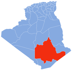
Illizi is a large province (wilaya) in the south-eastern corner of Algeria named after its eponymous seat. It borders Ouargla Province to the north, Tunisia to the extreme northeast, Libya to the east, Djanet Province to the south and, to the west, In Salah Province and Tamanrasset Province. As of the 2008 census, the province had a population of 52,333 and an annual growth rate of 4.5%.

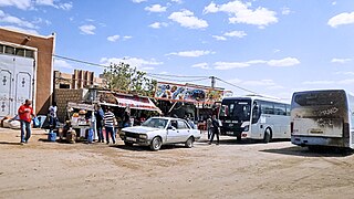
In Guezzam is a town and commune that is the capital of In Guezzam Province, Algeria, on the border with Niger. Until 26 November 2019, it was a part of the Tamanrasset Province. The border town on the Niger side is Assamaka. According to the 2008 census it had a population of 7,045, up from 4,938 in 1998, with an annual growth rate of 3.7%, the second highest in the Tamanrasset province's 2008 boundaries.

Tamanrasset, also known as Tamanghasset or Tamenghest, is an oasis city and capital of Tamanrasset Province in southern Algeria, in the Ahaggar Mountains. It is the chief city of the Algerian Tuareg. It is located an altitude of 1,320 metres (4,330 ft). As of the 2008 census, it has a population of 92,635, up from 72,741 in 1998, with an annual growth rate of 2.5%.

Abalessa is a town and commune in Tamanrasset Province, in southern Algeria, coextensive with the district of the same name. According to the 2008 census it has a population of 9,163 up from 6,484 in 1998, with an annual growth rate of 3.6%. Abalessa is located along the ancient Trans-Saharan trade route, 80 kilometres (50 mi) west of the city of Tamanrasset, the capital of the province. The postcode of the town is 11120.
In Amguel is a town and commune in Tamanrasset District, Tamanrasset Province, Algeria. According to the 2008 census it has a population of 4,208, up from 3,030 in 1998, with an annual growth rate of 3.4%. Its postal code is 11100 and its municipal code is 1109.

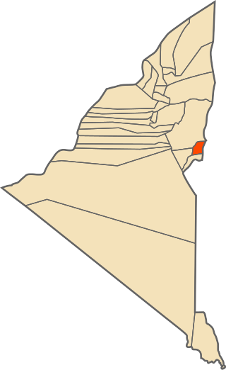
In Ghar is a town and commune, coextensive with the district of In Ghar, in In Salah Province, Algeria. According to the 2008 census it has a population of 11,225, up from 8,059 in 1998, with an annual growth rate of 3.4%. Its postal code is 11210 and its municipal code is 1103.

Tin Zaouatine is a commune, coextensive with the district of Tin Zaouatine, in In Guezzam Province, Algeria. According to the 2008 census it has a population of 4,157, up from 2,314 in 1998, with an annual growth rate of 6.2%, the highest rate in the province. Its postal code is 11150 and its municipal code is 1107.

Foggaret Ezzoua is a municipality in In Salah District, In Salah Province, Algeria. According to the 2008 census it has a population of 6,649, up from 4,763 in 1998, with an annual growth rate of 3.5%. Its postal code is 11220 and its municipal code is 1110.
Tazrouk is a town and commune, and district seat of Tazrouk District in Tamanrasset Province, Algeria. According to the 2008 census it has a population of 4,208, up from 3,033 in 1998, with an annual growth rate of 3.1%. Its postal code is 11140 and its municipal code is 1106.

Idlès is a municipality in Tazrouk District, Tamanrasset Province, Algeria. According to the 2008 census it has a population of 4,945, up from 3,791 in 1998, with an annual growth rate of 2.7%. Its postal code is 11110 and its municipal code is 1105. The largest nearby city is Tamanrasset; other smaller towns include In Amguel to the west and Tazrouk to the south.
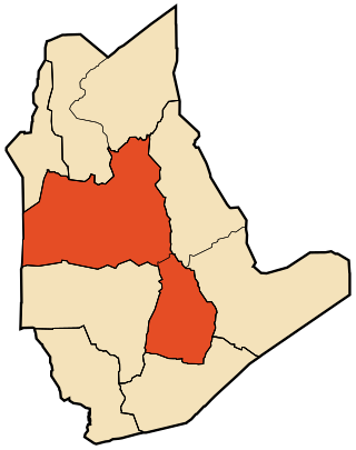
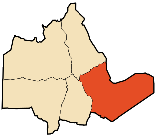
Tamanrasset is a district in Tamanrasset Province, Algeria. It was named after its capital, Tamanrasset, which is also the capital of the province. With 96,843 people, it is the most populated district in the province and one of the largest districts in the country.

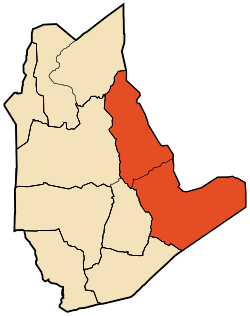
In Salah is a district in In Salah Province, Algeria. It was named after its capital, In Salah. According to the 2008 census, it has a population of 39,167.
Tit is a village in the commune of Tamanrasset, in Tamanrasset District, Tamanrasset Province, Algeria. It lies on the southern bank of Oued Abalessa 38 kilometres (24 mi) northwest of Tamanrasset city. It is known for the battle of Tit which took place in May 1902 between the French colonial empire and the Kel Ahaggar.
In Dalag is a village in the commune of Tamanrasset, in Tamanrasset District, Tamanrasset Province, Algeria. It lies on the west bank of Oued i-n-Daladj in the Hoggar Mountains, 48 kilometres (30 mi) east of Tamanrasset city.
Izernène is a village in the commune of Tamanrasset, in Tamanrasset District, Tamanrasset Province, Algeria. It lies in the Hoggar Mountains 28 kilometres (17 mi) northeast of the city of Tamanrasset.
Mertoutek is a village in the commune of Idlès, in Tazrouk District, Tamanrasset Province, Algeria. It lies in the northern Hoggar Mountains on the eastern side of a wadi, 61 kilometres (38 mi) northwest of the town of Idlès and 158 kilometres (98 mi) north of Tamanrasset.
Hirhafek is a village in the commune of Idlès, in Tazrouk District, Tamanrasset Province, Algeria. It is located on the southern side of the N55 national highway between In Amguel to the west and Idlès to the east. The village is 26 kilometres (16 mi) southwest of Idlès and 98 kilometres (61 mi) north of Tamanrasset.
Amguid is a village in the commune of Idlès, in Tazrouk District, Tamanrasset Province, Algeria. It is located in the remote north-eastern part of the province, about 400 kilometres (250 mi) north of Tamanrasset and 310 kilometres (190 mi) west of Illizi.
Tit is a town and commune in Aoulef District, Adrar Province, south-central Algeria. According to the 2008 census it has a population of 4,417, up from 3,160 in 1998, with an annual growth rate of 3.5%.
In Guezzam Province is a province (wilaya) in far southern Algeria that was created in 2019. It is the southernmost and least populous province of Algeria and lies on the border with Niger. It had a population of 11,202 in the present boundaries during the 2008 census.