Tchibanga

Last updated
Tchibanga
Coat of arms of Tchibanga, Gabon.svg
Gabon location map.svg
Red pog.svg
Tchibanga
Location in Gabon
Coordinates: 2°56′0″S11°0′0″E / 2.93333°S 11.00000°E / -2.93333; 11.00000 Coordinates: 2°56′0″S11°0′0″E / 2.93333°S 11.00000°E / -2.93333; 11.00000
CountryFlag of Gabon.svg  Gabon
Province Nyanga Province
Population
 (2008)
  Total24,000

Tchibanga is a city in the Nyanga Province of southern Gabon, situated on the Nyanga River. It has an estimated population of 24,000 (2008). The town lies on the N6 road and is home to Tchibanga Airport and a market. It lies near the Ivela Falls.

Contents

Tchibanga is the capital of the Nyanga province. Tchibanga is home to approximately 15,000 Gabonese people, but is also home to a sizeable refugee population from Congo-Brazzaville. The UNHCR runs an office there providing services for the refugees and locals. [1] The majority of people living in Tchibanga, including most Congolese refugees, belong to the Bapounou ethnic group.

Tchibanga sits on the banks of the Nyanga River. It is located in Gabon's southern grassland region and does not have the deep jungle environment of many Gabonese cities. Tchibanga has a thriving commercial district, a hospital, two high schools, a post office, a large Catholic church, and an airport. A small power station and a fresh water spring provide electricity and running water to the centre of town. President Omar Bongo has a summer house in Tchibanga that he has never used. The Minister of the Interior also has a house there.

Tchibanga is accessible by a twelve-hour bush taxi ride from Libreville or by aircraft to Tchibanga Airport. A local green and white taxi costs approximately 200 CFA francs.

Tchibanga has a number of restaurants serving both Western and traditional food. Some restaurants serve bush meat, including snake and antelope in a traditional palm oil sauce called Nyengui. Tchibanga is known for having the best manioc (cassava) in Gabon. Batons, or sticks of manioc wrapped in leaves, may be purchased for 100 Central African Francs at the market. A wide variety of other local produce is available at the market, including locally grown bananas, peanuts and hot peppers; the markets often sell bushmeat, such as antelope and monkey. Tchibanga is also a good place to buy traditional woven goods, including mats and baskets.

Notable people

Climate

Tchibanga has a tropical savanna climate (Köppen climate classification Aw), typical of this region of west-central Africa and not dissimilar to Kinshasa or Pointe-Noire. Unlike most places with a tropical savanna climate, the dry season from June to September is exceedingly foggy and sunless due to the influence of the cold Benguela Current. In fact, with only about 1,260 hours of sunshine per year, Tchibanga is one of the least sunny places in Africa and receives less sunshine than such cities as London or Juneau.

Climate data for Tchibanga (1961-1990)
MonthJanFebMarAprMayJunJulAugSepOctNovDecYear
Average high °C (°F)31.2
(88.2)
31.9
(89.4)
32.5
(90.5)
32.7
(90.9)
31.4
(88.5)
28.8
(83.8)
27.8
(82.0)
26.7
(80.1)
28.8
(83.8)
30.3
(86.5)
30.5
(86.9)
30.5
(86.9)
30.3
(86.5)
Daily mean °C (°F)26.8
(80.2)
27.1
(80.8)
27.5
(81.5)
27.7
(81.9)
26.8
(80.2)
24.3
(75.7)
23.3
(73.9)
22.8
(73.0)
25.0
(77.0)
26.3
(79.3)
26.4
(79.5)
26.4
(79.5)
25.9
(78.6)
Average low °C (°F)22.3
(72.1)
22.3
(72.1)
22.5
(72.5)
22.6
(72.7)
22.2
(72.0)
19.8
(67.6)
18.7
(65.7)
18.8
(65.8)
21.1
(70.0)
22.3
(72.1)
22.2
(72.0)
22.3
(72.1)
21.4
(70.5)
Average precipitation mm (inches)176.2
(6.94)
169.9
(6.69)
205.9
(8.11)
200.6
(7.90)
104.7
(4.12)
5.5
(0.22)
0.1
(0.00)
0.3
(0.01)
6.0
(0.24)
127.9
(5.04)
272.5
(10.73)
171.6
(6.76)
1,441.2
(56.74)
Average precipitation days13.614.516.214.87.00.70.20.42.114.120.315.1119.0
Average relative humidity (%)81807980818078787779818280
Mean monthly sunshine hours 137.2137.5146.6144.8116.977.580.158.943.287.9112.6115.01,258.2
Source: NOAA [3]

Related Research Articles

Gabon Country on the west coast of Central Africa

Gabon, officially the Gabonese Republic, is a country on the west coast of Central Africa. Located on the equator, Gabon is bordered by Equatorial Guinea to the northwest, Cameroon to the north, the Republic of the Congo on the east and south, and the Gulf of Guinea to the west. It has an area of nearly 270,000 square kilometres (100,000 sq mi) and its population is estimated at 2.1 million people. There are three distinct regions: the coastal plains, the mountains, and the savanna in the east. Gabon's capital and largest city is Libreville. The official language is French.

Geography of Gabon

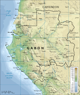
Gabon is a country in Central Africa, lying along the Atlantic Ocean, just south of the Bight of Biafra.

Armed Forces of Gabon

The Armed Forces of Gabon or the Gabonese Defense and Security Forces is the national professional military of the Republic of Gabon, divided into the Army, Air Force, Navy, and a National Gendarmerie, consisting of about 5,000 personnel. The armed forces includes a well-trained, well-equipped 1,800-member guard that provides security for the President of Gabon.

Libreville Capital and the largest city of Gabon

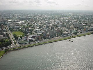
Libreville is the capital and largest city of Gabon. Occupying 65 square kilometres (25 sq mi) in the northwestern province of Estuaire, Libreville is a port on the Komo River, near the Gulf of Guinea. As of the 2013 census, its population was 703,904.

Pemba, Mozambique Place in Cabo Delgado Province, Mozambique

Pemba is a port city and district in Mozambique. It is the capital of the province of Cabo Delgado and lies on a peninsula in Pemba Bay.

Mouila Place in Ngounié Province, Gabon

Mouila is the capital of the Ngounié region of Gabon. It lies on the Ngounié River and the N1 road and has a population of about 20,000 people. Its main sight is Lac Bleu, a lake known for its bright blue water.

Franceville Place in Haut-Ogooué Province, Gabon

Franceville is one of the four largest cities in Gabon, with a population of 110,568 at the 2013 census. It lies on the River Mpassa and at the end of the Trans-Gabon Railway and the N3 road. It grew from a village named Masuku when Pierre Savorgnan de Brazza chose it to resettle former slaves and renamed it Francheville in 1880. The city later came to be called Franceville.

Mayumba, Gabon Place in Nyanga Province, Gabon

Mayumba is a Vili- and Shira-speaking town of about 5,208 people on the Atlantic Ocean coast of Gabon, at the end of the N6 road, lying on a peninsula separated from the mainland by the Banio Lagoon.

Garanhuns Municipality in Northeast, Brazil

Garanhuns is a city in the Brazilian state of Pernambuco. Located in the Borborema Plateau, the town is known as the "Suíça Pernambucana" due to its elevation and relatively cool climate. It is also known as "Cidade das Flores" or "Cidade da Garoa".

Loango National Park

Loango National Park is a national park in western Gabon. It protects diverse coastal habitat, including part of the 220 km² Iguéla Lagoon, the only significant example of a typical western African lagoon system that is protected within a national park.

Index of Democratic Republic of the Congo–related articles Wikipedia index

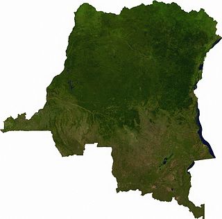
Articles related to the Democratic Republic of the Congo include:

The wildlife of Gabon is composed of its flora and fauna. Gabon is a largely low-lying country with a warm, humid climate. Much of the country is still covered by tropical rainforest and there are also grasslands, savannas, large rivers and coastal lagoons.

Gicumbi District District in Rwanda

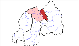
Gicumbi is a district (akarere) in Northern Province, Rwanda. Its capital is Byumba, which is also the provincial capital.

Wildlife of Togo

The wildlife of Togo is composed of the flora and fauna of Togo, a country in West Africa. Despite its small size the country has a diversity of habitats; there are only remnants of the once more extensive rain forests in the south, there is Sudanian Savanna in the north-western part of the country and larger areas of Guinean forest-savanna mosaic in the centre and northeast. The climate is tropical with distinct wet and dry seasons. There are estimated to be over 3000 species of vascular plant in the country, and 196 species of mammal and 676 species of bird have been recorded there.

Outline of Gabon Overview of and topical guide to Gabon

The following outline is provided as an overview and topical guide to Gabon :

Atlantic Equatorial coastal forests

The Atlantic Equatorial coastal forests, also known as the Congolian coastal forests, are a tropical moist broadleaf forest ecoregion of central Africa, covering hills, plains, and mountains of the Atlantic coast of Cameroon, Equatorial Guinea, Gabon, Republic of the Congo, Angola, and Democratic Republic of the Congo.

The Gabonese people have forged since the independence of the country, in 1960, their own culture which is neither the traditional culture of the different ethnic groups which compose it, nor modern Western culture. It is a culture in movement, a mixture of diversity and common traits, bringing together the most diverse beliefs and practices.

Sankuru Province of the Democratic Republic of the Congo

Sankuru is one of the 21 new provinces of the Democratic Republic of the Congo created in the 2015 repartitioning. Sankuru, Kasaï-Oriental, and Lomami provinces are the result of the dismemberment of the former Kasaï-Oriental province. Sankuru was formed from the Sankuru District whose town of Lusambo was elevated to capital city of the new province.

West Sudanian savanna

The West Sudanian savanna is a tropical savanna ecoregion that extends across West Africa.

References

  1. Congolese refugees in Gabon
  2. Batassi, Pierre Eric Mbog. "Annie Flore Batchiellilys : la différence en partage". www.afrik.com. Retrieved 5 November 2017.
  3. "Tchiban Climate Normals 1961–1990". National Oceanic and Atmospheric Administration . Retrieved 6 November 2016.