The Huilliche[wi.ˈʝi.tʃe], Huiliche or Huilliche-Mapuche are the southern partiality of the Mapuche macroethnic group of Chile. Located in the Zona Sur, they inhabit both Futahuillimapu and, as the Cunco subgroup, the north half of Chiloé Island. The Huilliche are the principal indigenous people of those regions. According to Ricardo E. Latcham the term Huilliche started to be used in Spanish after the second founding of Valdivia in 1645, adopting the usage of the Mapuches of Araucanía for the southern Mapuche tribes. Huilliche means 'southerners' A genetic study showed significant affinities between Huilliches and indigenous peoples east of the Andes, which suggests but does not prove a partial origin in present-day Argentina.
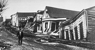
The 1960 Valdivia earthquake and tsunami or the Great Chilean earthquake on 22 May 1960 was the most powerful earthquake ever recorded. Various studies have placed it at 9.4–9.6 on the moment magnitude scale. It occurred in the afternoon, and lasted for approximately 10 minutes. The resulting tsunamis affected southern Chile, Hawaii, Japan, the Philippines, eastern New Zealand, southeast Australia, and the Aleutian Islands.

Austral University of Chile is a Chilean research university based primarily in Valdivia, with a satellite campus in Puerto Montt. Founded on September 7, 1954, it is one of the eight original Chilean Traditional Universities. It operates as a nonprofit self-owned corporation under private law, and receives significant state-funding.

Valdivia is a city and commune in southern Chile, administered by the Municipality of Valdivia. The city is named after its founder Pedro de Valdivia and is located at the confluence of the Calle-Calle, Valdivia, and Cau-Cau Rivers, approximately 15 km (9 mi) east of the coastal towns of Corral and Niebla. Since October 2007, Valdivia has been the capital of Los Ríos Region and is also the capital of Valdivia Province. The national census of 2017 recorded the commune of Valdivia as having 166,080 inhabitants (Valdivianos), of whom 150,048 were living in the city. The main economic activities of Valdivia include tourism, wood pulp manufacturing, forestry, metallurgy, and beer production. The city is also the home of the Austral University of Chile, founded in 1954 and the Centro de Estudios Científicos.

The Valdivia River or Río Valdivia, as it is known locally, is a major river in southern Chile. It is the continuation of the Calle-Calle River, from the point where it meets the Cau-Cau River in the city of Valdivia. The Valdivia river ends in Corral Bay, on the Pacific coast. Other tributaries are the Cruces River, the Tornagaleones River and the Futa River. Pedro de Valdivia Bridge crosses the river in downtown Valdivia.

The Cruces River is a river in south-central Chile. Río Cruces originates from hills near the Villarica volcano and flows then in south-west direction. The southern and final part of the river flows in a south-south-west direction following the eastern flank of Cordillera de Oncol. At the latitude of the city of Valdivia it is crossed by Río Cruces Bridge next to its outflow into Valdivia River.

Mancera Island is a minor island at the mouth of Valdivia River in Corral Bay.
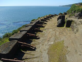
The Fort System of Valdivia are a series of Spanish colonial fortifications at Corral Bay, Valdivia and Cruces River established to protect the city of Valdivia, in southern Chile. During the period of Spanish rule (1645–1820), it was one of the biggest systems of fortification in the Americas. It was also a major supply source for Spanish ships that crossed the Strait of Magellan.

Caucau River is minor river in the city of Valdivia, southern Chile. Caucau River acts as a regulating channel between Cruces River and Calle-Calle River forming the Isla Teja island in front of the city centre. It confluence with Calle-Calle River marks the beginning of Valdivia River. '

Calle-Calle River, also called Gudalafquén in Mapuche language, is a river in Valdivia Province, southern Chile. It drains waters from the San Pedro River to the Valdivia River, which in turn flows into Corral Bay on the Pacific Ocean.

Zona Sur is one of the five natural regions on which CORFO divided continental Chile in 1950. Its northern border is formed by the Bío-Bío River, which separates it from the Central Chile Zone. The Southern Zone borders the Pacific Ocean to the west, and to the east lies the Andean mountains and Argentina. Its southern border is the Chacao Channel, which forms the boundary with the Austral Zone. While the Chiloé Archipelago belongs geographically to the Austral Zone in terms of culture and history, it lies closer to the Southern Zone.
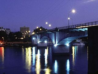
Pedro de Valdivia Bridge is an arch bridge spanning Valdivia River, that separates downtown Valdivia from Isla Teja island a residential area. Together with Río Cruces Bridge it allows connection from Valdivia to the coastal town Niebla.

Isla del Rey is a river island the largest island in Los Ríos Region of Chile. It is located near the outflow of Valdivia River into Corral Bay. To the east, south and southwest the island is separated from the mainland by Tornagaleones River. To the north it is bounded by Valdivia River. Next to it, to the east, lies Guacamayo Island. The island is described in Diccionario Geográfico de la República de Chile (1899) as "somewhat mountainous, high, with some forest and various streams that descend towards its margins".
Celulosa Arauco y Constitución is a Chilean wood pulp, engineered wood and forestry company controlled by Anacleto Angelini's economic group; Empresas Copec. In 2006 CELCO/ARAUCO had five pulp mills in Chile and one in Argentina. Apart from pulp mills, CELCO/ARAUCO has 4 engineered wood manufacturing plants in Chile, 2 in Argentina and 2 in Brazil.
Valdivia is one of the few cities in southern Chile with a more less continuous and well documented history from its foundation in the 16th century onwards.

Tornagaleones River is a river and eastuarine channel in Los Ríos Region, Chile. Together with Valdivia and Futa River it encloses the fluvial island of Isla del Rey. The fresh waters of Tornagaleones comes from Futa, Naguilán and Valdivia River. During high tide brackish waters from Corral Bay enters the channel.
The Angachilla River is a river of Chile. The river and the wetland of the same name drains toward Valdivia River to which it connects near San Ramón Peninsula. The southern peripheral neighborhoods of Valdivia reaches the revier.
Francisco Pérez de Valenzuela, was a nobleman of the Kingdom of Spain. He traveled to the Americas, where was appointed as military and navy leader by the Spanish Crown in the Viceroyalty of Peru, being captain in some battles. During his last days he was a Royalist politician nominated and elected Corregidor so called City Mayor in Valdivia, city-port founded by his countryman named Peter of Valdivia conqueror of Chile. There he did a good job making strategies protecting southern cities, forts and ports, and avoiding attacks by pirates. He also was a businessman like his father named Alonso Pérez de Valenzuela y de la Cava.
In Chilean historiography, Colonial Chile is the period from 1600 to 1810, beginning with the Destruction of the Seven Cities and ending with the onset of the Chilean War of Independence. During this time, the Chilean heartland was ruled by Captaincy General of Chile. The period was characterized by a lengthy conflict between Spaniards and native Mapuches known as the Arauco War. Colonial society was divided in distinct groups including Peninsulars, Criollos, Mestizos, Indians and Black people.
From 1850 to 1875, some 6,000 German immigrants settled in the region around Valdivia, Osorno and Llanquihue in Southern Chile as part of a state-led colonization scheme. Some of these immigrants had left Europe in the aftermath of the German revolutions of 1848–49. They brought skills and assets as artisans, farmers and merchants to Chile, contributing to the nascent country's economic and industrial development.
