
Achziv is an ancient site on the Mediterranean coast of northern Israel, between the border with Lebanon and the city of Acre. It is located 13.5 kilometres (8.4 mi) north of Acre on the coast of the Mediterranean Sea, within the municipal area of Nahariya. Today it is an Israeli national park.
Beit She'an, also known as Beisan, and historically known as Scythopolis is a city in the Northern District of Israel, which has played an important role in history due to its geographical location at the junction of the Jordan River Valley and the Jezreel Valley. In the Biblical account of the battle of the Israelites against the Philistines on Mount Gilboa, the bodies of King Saul and three of his sons were hung on the walls of Beit She'an. In Roman times, Beit She'an was the leading city of the Decapolis, a league of pagan cities. In modern times, Beit She'an serves as a regional centre for the settlements in the Beit She'an Valley.

Yavne or Yavneh is a city in the Central District of Israel. In many English translations of the Bible, it is known as Jabneh. During Greco-Roman times, it was known as Jamnia ; to the Crusaders as Ibelin; and before 1948, as Yibna.

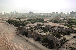
Apollonia, known in the Early Islamic period as Arsuf and in the Crusader Kingdom of Jerusalem as Arsur, was an ancient city on the Mediterranean coast of what is today Israel. In Israeli archaeology it is known as Tel Arshaf. Founded by the Phoenicians during the Persian period in the late sixth century BCE, it was inhabited continuously until the Crusader period, through the Hellenistic, Roman, and Byzantine periods, during the latter being renamed to Sozusa. It was situated on a sandy area ending towards the sea with a cliff, about 34 kilometres (21 mi) south of Caesarea.

The archaeology of Israel is the study of the archaeology of the present-day Israel, stretching from prehistory through three millennia of documented history. The ancient Land of Israel was a geographical bridge between the political and cultural centers of Mesopotamia and Egypt. Despite the importance of the country to three major religions, serious archaeological research only began in the 15th century. The first major work on the antiquities of Israel was Adriaan Reland's Palestina ex monumentis veteribus, published in 1709. Edward Robinson, an American theologian who visited the country in 1838, published the first topographical studies. Lady Hester Stanhope performed the first modern excavation at Ashkelon in 1815. A Frenchman, Louis Felicien de Saucy, embarked on early "modern" excavations in 1850.

Rehov, meaning "broad", "wide place", was an important Bronze and Iron Age city located at Tel Rehov or تل الصارم Tell es-Sarem, an archaeological site in the Bet She'an Valley, a segment of the Jordan Valley, Israel, approximately 5 kilometres (3.1 mi) south of Beit She'an and 3 kilometres (1.9 mi) west of the Jordan River.
Ashdod-Yam is an archaeological site on the Mediterranean coast of Israel. It is located in the southern part of the modern city of Ashdod, and about 5 kilometres northwest of Tel Ashdod where Ashdod stood in the time of the Philistines. Ashdod on the Sea and (inland) Ashdod were for most of their history two separate entities, connected though by close ties with each other. At different times in history one of the two twin towns would gain the upper hand over the other. There is more on the two towns and their interaction in the Ashdod article.
Tel Shikmona, also spelt Sycamine, is an ancient tell (mound) situated near the sea coast on the modern city of Haifa, Israel, just south of the Israeli National Institute of Oceanography.
Caesarea, Keysariya or Qesarya, often simplified to Keisarya, and Qaysaria, is a town in north-central Israel, which inherits its name and much of its territory from the ancient city of Caesarea Maritima. Located midway between Tel Aviv and Haifa on the coastal plain near the city of Hadera, it falls under the jurisdiction of Hof HaCarmel Regional Council. With a population of 5,343, it is the only Israeli locality managed by a private organization, the Caesarea Development Corporation, and also one of the most populous localities not recognized as a local council.

Jisr az-Zarqa is an Israeli Arab town on Israel's northern Mediterranean coastal plain. Located just north of Caesarea within the Haifa District, it achieved local council status in 1963. According to the Central Bureau of Statistics (CBS) the town had a population of 13,689 in 2014, living on 1,500 dunams (1.5 km2) of coastal land. 80% of residents reportedly live below the poverty line. The name Jisr az-Zarqa is a reference to Taninim Stream, which is known in Arabic as the "Blue Valley". The mayor is Az-Adin Amash.

Besor is a wadi in southern Israel. The stream begins at Mount Boker, and spills into the Mediterranean Sea near Al-Zahra in the Gaza Strip, where it is called Wadi Ghazzeh, also spelled Wadi Gaza. Further upstream it is marked as Wadi esh-Shallaleh on the 1878 Survey of Western Palestine map. There are several important archaeological sites located in this area.

Farwana, was a Palestinian village, located 4.5 kilometers (2.8 mi) south of Bisan, depopulated in 1948.

Jacob's Ford is a ford on the upper Jordan River where a number of bridges were built throughout history, giving rise to the medieval name Daughters of Jacob Bridge. The bridges span the last natural ford of the Jordan at the southern end of the Hula Basin between the Korazim Plateau and the Golan Heights. The ford, then the bridges, have been a crossing point for thousands of years.

Nahal Taninim or Wadi az-Zarka is a river in Israel near the Arab town Jisr az-Zarqa, originating near Ramot Menashe and emptying into the Mediterranean Sea south of Ma'agan Michael. It marks the southern limit of the Hof HaCarmel, or Carmel Coastal Plain region.
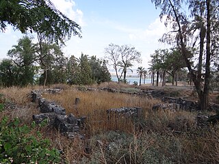
Al-Sinnabra or Sinn en-Nabra, is the Arabic place name for a historic site on the southern shore of the Sea of Galilee in modern-day Israel. The ancient site lay on a spur from the hills that close the southern end of the Sea of Galilee, next to which towards its south being the tell, Khirbet Kerak or Bet Yerah, one of the largest in the Levant, spanning an area of over 50 acres. Bet Yerah was the Hellenistic era twin city of Sennabris, as al-Sinnabra was known in Classical antiquity, and its remains are located at the same tell.

Nahal Poleg is a stream in the Sharon plain in Israel that empties into the Mediterranean Sea between Netanya and the Wingate Institute.

Tel Yokneam, also spelled Yoqne'am or Jokneam, is an archaeological site located between the modern city of Yokneam Illit and the town of Yokneam Moshava. It was known in Arabic by a variant name, Tell Qamun, believed to be a corruption of the Hebrew name. The site is an elevated mound, or tel, spanning around 40 dunams and rising steeply to a height of 60 meters (200 ft). With a few brief interruptions, Yokneam was occupied for 4,000 years, from the Middle Bronze Age to the Ottoman Empire.
Tel Shush or Tell Abu Shusha is a tell located next to Kibbutz Mishmar HaEmek on the eastern slopes of the Menashe Heights, overlooking the Jezreel Valley. The tell's area is about 40 dunams and it rises to a height of 50 meters from its foot. The site was identified with Geva, mentioned in the list of cities conquered by Thutmose III; Geva‘ Parashim, mentioned by Josephus; and Gaba Philippi from Roman times. The site contains remains of human settlement from the Bronze Age, Iron Age, Persian, Hellenistic, Roman, Byzantine, Early Arab, Crusader, Mamluk and Ottoman periods.
Tel Mevorakh is a small mound situated on the southern bank of Nahal Taninim in Israel. The tel does not exceed 1 dunam but rises to a height of 15 metres (50 ft) above its surrounding plain. The site contains some fifteen layers of human settlement, which accumulate to a height of 8 meters, meaning the natural hill does not exceed a height of 7 meters. It is located on the border between the wide Sharon Plain and the coast of Mount Carmel.
