
The Pembrokeshire Coast Path, often called the Pembrokeshire Coastal Path, is a designated National Trail in Pembrokeshire, southwest Wales. Established in 1970, it is a 186-mile (299 km) long-distance walking route, mostly at cliff-top level, with a total of 35,000 feet (11,000 m) of ascent and descent. At its highest point – Pen yr afr, on Cemaes Head – it reaches a height of 574 feet (175 m), and at its lowest point – Sandy Haven crossing, near Milford Haven – it is just 6 feet (2 m) above low water. Whilst most of the coastline faces west, it offers – at varying points – coastal views in every direction of the compass.

The Old Red Sandstone is an assemblage of rocks in the North Atlantic region largely of Devonian age. It extends in the east across Great Britain, Ireland and Norway, and in the west along the northeastern seaboard of North America. It also extends northwards into Greenland and Svalbard. These areas were a part of the ancient continent of Euramerica/Laurussia. In Britain it is a lithostratigraphic unit to which stratigraphers accord supergroup status and which is of considerable importance to early paleontology. For convenience the short version of the term, ORS is often used in literature on the subject. The term was coined to distinguish the sequence from the younger New Red Sandstone which also occurs widely throughout Britain.

Pembrokeshire Coast National Park is a national park along the Pembrokeshire coast in west Wales.
Gateholm or Gateholm Island is a small tidal island off the south west coast of Pembrokeshire, in the community of Marloes and St Brides, in the south west side of Wales, in the west of the UK, and about 8 miles (13 km) west of the port of Milford Haven. It is known for its Romano-British remains. Gateholm is owned by the National Trust as part of their Marloes Sands and Mere estate.

Ramsey Island is an island about 1 kilometre off St David's Head in Pembrokeshire on the northern side of St Brides Bay, in southwest Wales, in the community of St Davids and the Cathedral Close. It is 259 hectares in area. Ramsey means Hrafn's island.

St Brides Bay is a bay in western Pembrokeshire, West Wales.

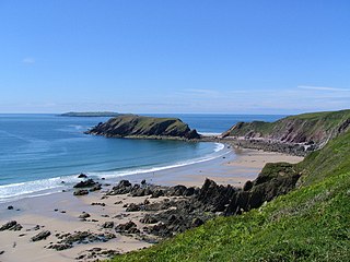
Strumble Head is a rocky headland in the community of Pencaer in Pembrokeshire, Wales, within the Pembrokeshire Coast National Park. It marks the southern limit of Cardigan Bay. Three islands lie off the head: Ynys Meicel – 112 feet (34 m) – Ynys Onnen and Carreg Onnen.

The Bishops and Clerks are a group of rocks and islets, approximately 1+1⁄2 miles (2.4 km) west of Ramsey Island, Pembrokeshire, Wales.

Henrhyd Falls in the Brecon Beacons National Park, Wales, is the tallest waterfall in southern Wales with a drop of 90 feet (27 m). It lies on National Trust land, in the county of Powys. The nearest settlement to it is Coelbren, on the road between Glynneath and Abercraf. Though not in the core of the area, it is considered by many to constitute a part of Wales' celebrated Waterfall Country.

Caerfai Bay is a rocky cove on the north coast of St Brides Bay near St Davids in Pembrokeshire, West Wales. It is enclosed by steep varicoloured cliffs and has a sandy beach at low tide accessed by pathway and steps. The beach is situated in the Pembrokeshire Coast National Park and on the Pembrokeshire Coast Path. There is free parking above the beach with picnic benches and views of the islands of Penpleidiau, Skomer and Skokholm.

The Marros Group is the name given to a suite of rocks of Namurian age laid down during the Carboniferous Period in South Wales. These rocks were formerly known as the Millstone Grit Series but are now distinguished from the similar but geographically separate rock sequences of the Pennines and Peak District of northern England and northeast Wales by this new name.
The Farewell Rock is the name given to a series of sandstones at the boundary of the Coal Measures with the underlying Marros Group in South Wales. Once thought to be a single sandstone, it is now accepted that the same name has been applied to several different sandstones of similar age across the South Wales Coalfield. The sandstone unit known as the Farewell Rock in the Pembrokeshire Coalfield is continuous with the Cumbriense Quartzite of the main South Wales Coalfield. These are assigned to the uppermost part of the Marros Group which is of Namurian age. In the South Wales Coalfield, the name is given to a thicker, overlying sandstone unit which, though formerly assigned to the Millstone Grit Series, is now assigned to the Lower Coal Measures which are of Westphalian age.

Ceibwr Bay is a bay opening into the Irish Sea in Pembrokeshire, west Wales. It is about 7 km west of Cardigan, and 3 km south of the headland of Cemaes Head. It is owned by the National Trust, within the Pembrokeshire Coast National Park and on the Pembrokeshire Coast Path.

The Exmoor Group is a late Devonian to early Carboniferous lithostratigraphic group in southwest England whose outcrop extends from Croyde in north Devon east across Exmoor to Minehead in west Somerset. The group comprises the following formations the:
Marros Sands is a beach in Carmarthenshire between Amroth and Pendine and to the south of the small settlement of Marros.
This article describes the geology of the Brecon Beacons National Park in mid/south Wales. The area gained national park status in 1957 with the designated area of 1,344 km2 (519 sq mi) including mountain massifs to both the east and west of the Brecon Beacons proper. The geology of the national park consists of a thick succession of sedimentary rocks laid down from the late Ordovician through the Silurian and Devonian to the late Carboniferous period. The rock sequence most closely associated with the park is the Old Red Sandstone from which most of its mountains are formed. The older parts of the succession, in the northwest, were folded and faulted during the Caledonian orogeny. Further faulting and folding, particularly in the south of the park is associated with the Variscan orogeny.
The geology of the Gower Peninsula in South Wales is central to its character and to its appeal to visitors. The peninsula is formed almost entirely from a faulted and folded sequence of Carboniferous rocks though both the earlier Old Red Sandstone and later New Red Sandstone are also present. Gower lay on the southern margin of the last ice sheet and has been a focus of interest for researchers and students in that respect too. Cave development and the use of some for early human occupation is a further significant aspect of the peninsula's scientific and cultural interest.
The bedrock geology of Carmarthenshire in west Wales consists largely of Palaeozoic age sedimentary rocks. Unconsolidated deposits of Quaternary age in Carmarthenshire include a dissected cover of glacial till, valley floor alluvium and some scattered peat deposits in both upland and lowland settings. There are extensive beach and tidal flat deposits along the Carmarthenshire coast. The exploitation of the county's mineral riches, particularly coal and limestone, was a key part of the local economy through much of the nineteenth and twentieth centuries.
Milford Haven Waterway, is a Site of Special Scientific Interest (SSSI) on Milford Haven Waterway in Pembrokeshire, South Wales, designated since 2002. The site is protected for a wide range of reasons, including its geology, marine environment and ecosystems, and to protect a diversity of flora and fauna.
