Tempelhofer Feld

Last updated
Tempelhofer Feld
Tempelhofer Feld May 2021.jpg
Tempelhofer Feld in May 2021
Tempelhofer Feld
Type Urban park
Location Berlin, Germany
Coordinates 52°28′34″N13°23′42″E / 52.476°N 13.395°E / 52.476; 13.395
Area355 hectares (3.55 km2)
Website gruen-berlin.de
Tempelhofer Feld

Tempelhofer Feld (English: Tempelhof Field) historically was an area in Berlin used for military practice, and as a parade ground of the Berlin garrison. It belonged to the Tempelhofer uplands on the Teltow plateau, in the south of Berlin. Tempelhofer Feld is closely linked to German military and aviation history, as well as German soccer history. Today it is a developed area, with the exception of the Tempelhofer Feld park on the site of the former Tempelhof Airport.

Contents

History

Berlin Tempelhofer Feld 1907.jpg
Excerpt from the supplement to the address book for Berlin and its suburbs, 1907; also highlighted is the Paradepappel
Historische Pappel.jpg
The historic poplar on the Tempelhofer Felde. It stood since the time of the Soldier King and King Frederick the Great. Here, the 3rd Regiment of Foot Guards pass by.
Bundesarchiv Bild 102-02375, Berlin, Tempelhofer Feld.jpg
Aerial view of Tempelhofer Feld, May 1, 1933
Berlin Tempelhofer Feld UAV 05-2017.jpg
Aerial view of Tempelhof Field, 2017
Tempelhofer Flugfeld Mai 2010.jpg
Opening of the Tempelhofer Park in May 2010
Aerial view of Tempelhofer Feld to the east

On 3 November 1897, the world's first rigid airship, an all-metal craft designed by Hungarian inventor David Schwarz, equipped with a 12-hp/9-kW Daimler engine, and shaped like a short, fat pencil, set off on its maiden flight from Tempelhofer Feld. It was destroyed on landing; pilot Ernst Jagels escaped with minor injuries.

Parade ground

The field located between the towns of Schöneberg and Tempelhof, then also known as Großes Feld (Great Field), was used by Schöneberg farmers as farmland until the 18th century. Under Frederick William I, it was also used as a military parade and drill ground from 1722 onwards, as well as a maneuvering area for the Prussian army. On August 2, 1881, the Hawaiian king Kalākaua was guest of a parade on the field. [1] The function as a parade ground was maintained until spring 1914.

Berlin-Tempelhof Airport

In 1922, work began to turn the area into Tempelhof Airport. The initial construction was completed by 1928, with further expansion planned by Ernst Sagabiel in 1934. The new airport building was then built from 1936 to 1941.

Starting in 1940, the airport building was used exclusively by the arms industry. For example, for the assembly and maintenance of the dive combat aircraft Ju 87. To conduct this work, thousands of forced laborers were brought from all over Europe, with their camps and accommodations located on the field itself.

After the end of World War II, flight operations resumed. The airport gained particular importance during the Berlin blockade from 1948 to 1949, with supply aircraft sometimes landing as often as every 90 seconds.

In 1970, after the construction of Tegel Airport, the airport was temporarily closed to civilian air traffic, reopening in 1985. All flight operations were later discontinued completely in 2008, due to the construction of the Berlin Brandenburg International Airport (BER), although this airport did not open until 2020.

Dispute about the continued use of the area

Two German political parties, the CDU and FDP, initiated a referendum against the shutdown of flight operations. The referendum ultimately failed after not getting enough support from local citizens. [2]

Later, several thousand activists came together in an alliance called Squat Tempelhof in order to occupy the site and protest against the plans for re-use. This planned mass occupation of the closed field was to make the point that the area (unused and fenced off at the time), should be accessible to citizens. The Berlin Senate had promised that after the closure of the airport, the space would be opened to the general population but by June 2009 this had not yet happened. Many residents, as well as tenant alliances and the Green party came together to organize. [3] However, the occupation was prevented by the police. Around 1,500 officers were on duty and 102 demonstrators were arrested. [4]

Tempelhofer Feld park

2010 Opening

The field re-opened on May 8, 2010 as Tempelhofer Park, a recreational area in Berlin districts Neukölln and Tempelhof. During the first open weekend, the park was visited by around 235,000 visitors. [5]

Park description

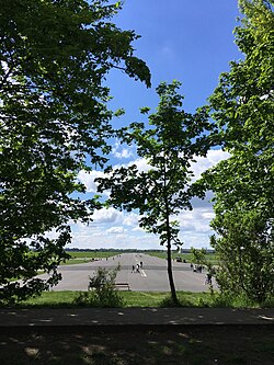
Now officially called Tempelhofer Feld, it covers 355 hectares of the site of the former Tempelhof Airport, including its buildings and surrounding land, making it the largest inner city open space in the world, [6] and Berlin's largest city park.

The park is accessible from sunrise to sunset and can be accessed via ten entrances. Six of them are located at the eastern end of the former runways along Oderstraße, two at Tempelhof station and the Paradestraße U-Bahn at Tempelhofer Damm, and two at Columbiadamm, on the level of the 1866 Islamic cemetery with the Şehitlik Mosque, and Golßener Straße. [7]

Unsuccessful development attempts

Throughout the time that Tempelhofer Feld has functioned as a public park, there have been many attempts to develop and privatize it. Each time there has been significant citizen pushback.

The Berlin Senate is officially responsible for the park planning, though private initiatives have also tried to realize their plans for the field. This has led to additional planning conflicts as there is no independent mediation institution between these two interest groups. Many plans were made, including hosting the International Garden Exhibition (IGA), a state library, and housing. These plans were stopped completely by a successful citizen's referendum in 2014. [8] [9]

The activism necessary to save the park was ongoing for several years, starting with the founding of the citizen's action group called 100% Tempelhofer Feld in September 2011. Their aim was to stop Senate plans and prevent all future building on the site. They organized the referendum to completely preserve the public space, so that it could not be used for state, residential or commercial purposes. [10] They announced a petition in autumn 2012 and began the collection of signatures that December. On May 25, 2014 the referendum passed with 64.3 percent of votes in favor. [9] [11]

Related Research Articles

<span class="mw-page-title-main">Berlin Brandenburg Airport</span> International airport serving Berlin, Germany

Berlin Brandenburg Airport Willy Brandt is an international airport in Schönefeld, just south of the German capital Berlin in the state of Brandenburg. Named after the former West Berlin mayor and West German chancellor Willy Brandt, it is located 18 kilometres (11 mi) south-east of the city centre and serves as a base for Eurowings and Ryanair. It mostly has flights to European metropolitan and leisure destinations as well as a number of intercontinental services.

<span class="mw-page-title-main">Berlin Schönefeld Airport</span> 1934–2020 airport of Berlin, Germany

Berlin Schönefeld Airport was the secondary international airport of Berlin, the capital of Germany. It was located 18 km (11 mi) southeast of Berlin near the town of Schönefeld in the state of Brandenburg and bordered Berlin's southern boundary. It was the smaller of the two airports in Berlin, after Berlin Tegel Airport, and served as a base for easyJet and Ryanair. In 2017, the airport handled 12.9 million passengers by serving mainly European metropolitan and leisure destinations. In the same year, the travel portal eDreams ranked Berlin Schönefeld as the worst airport in the world after evaluating 65,000 airport reviews. Schönefeld Airport also was the major civil airport of East Germany (GDR) and the only airport of the former East Berlin.

<span class="mw-page-title-main">Berlin Tegel Airport</span> Former airport of Berlin, Germany (1948—2020)

Berlin Tegel "Otto Lilienthal" Airport was the former primary international airport of Berlin, the federal capital of Germany. The airport was named after aviation pioneer Otto Lilienthal and was the fourth busiest airport in Germany, with over 24 million passengers in 2019. In 2016, Tegel handled over 60% of all airline passenger traffic in Berlin. The airport served as a base for Eurowings, Ryanair as well as easyJet. It featured flights to several European metropolitan and leisure destinations as well as some intercontinental routes. It was situated in Tegel, a section of the northern borough of Reinickendorf, eight kilometres northwest of the city centre of Berlin. Tegel Airport was notable for its hexagonal main terminal building around an open square, which made walking distances as short as 30 m (100 ft) from the aircraft to the terminal exit.

<span class="mw-page-title-main">Berlin Tempelhof Airport</span> 1923–2008 airport of Berlin, Germany

Berlin Tempelhof Airport was one of the first airports in Berlin, Germany. Situated in the south-central Berlin borough of Tempelhof-Schöneberg, the airport ceased operating in 2008 amid controversy, leaving Tegel and Schönefeld as the two main airports serving the city for another twelve years until both were replaced by Berlin Brandenburg Airport in 2020.

<span class="mw-page-title-main">Tempelhof</span> Quarter of Berlin in Germany

Tempelhof is a locality of Berlin within the borough of Tempelhof-Schöneberg. It is the location of the former Tempelhof Airport, one of the earliest commercial airports in the world. The former airport and surroundings are now a park called Tempelhofer Feld, making it the largest inner city open space in the world.

<span class="mw-page-title-main">Schönefeld</span> Municipality in Brandenburg, Germany

Schönefeld is a suburban municipality in the Dahme-Spreewald district, Brandenburg, Germany. It borders the southeastern districts of Berlin. The municipal area encompasses the old Berlin Schönefeld Airport (SXF) and the new Berlin Brandenburg Airport (BER).

<span class="mw-page-title-main">Viktoriapark</span> Park in Berlin

The Viktoriapark is an urban park in the locality of Kreuzberg in Berlin, Germany. It opened in 1894.

<span class="mw-page-title-main">Platz der Luftbrücke (Berlin U-Bahn)</span> Station of the Berlin U-Bahn

Platz der Luftbrücke is a Berlin U-Bahn station located on the U6. It is located under Platz der Luftbrücke and the south end of Mehringdamm on the border between Kreuzberg and Tempelhof, near the former Tempelhof International Airport, and is now named for the square there with its memorial to the victims of the Berlin Airlift.

<span class="mw-page-title-main">Paradestraße (Berlin U-Bahn)</span> Station of the Berlin U-Bahn

Paradestraße is a Berlin U-Bahn station on the U6 line. It was opened in 1927 as Flughafen (airport) and at that time provided the world's first direct connection between a metro system and an airport.

<span class="mw-page-title-main">Berlin-Tempelhof station</span> Railway station in Berlin, Germany

Tempelhof is a railway station in the district of Berlin with the same name. It is served by the S-Bahn lines S41, S42, S45 and S46 and the U-Bahn line U6. The S-Bahn station is on an embankment at the junction of Tempelhofer Damm and Bundesautobahn 100, about 1 km south of the entrance to the former Tempelhof Airport. The U-Bahn station, officially called Tempelhof (Südring), is under Tempelhofer Damm immediately south of the S-Bahn station.

<span class="mw-page-title-main">Neukölln (locality)</span> Quarter of Berlin in Germany

Neukölln, until 1920 an independent city, is a large inner-city quarter (Ortsteil) of Berlin in the homonymous borough (Bezirk) of Neukölln, including the historic village of Alt-Rixdorf and numerous Gründerzeit apartment blocks. With 166,714 inhabitants (2018) the Ortsteil is the most densely populated of Berlin. It was originally characterized by mostly working-class inhabitants and later a relatively high percentage of immigrants, especially of Turkish and Russian descent, but since the turn of the millennium an influx of students, creatives, and western immigrants has led to gentrification.

<span class="mw-page-title-main">Platz der Luftbrücke</span>

Platz der Luftbrücke is a landmarked square and transport node in Berlin, Germany, on the border between the localities of Tempelhof and Kreuzberg. The entrance to the former Tempelhof International Airport is on the square. The buildings around the square are now mostly government agencies, in particular police headquarters. The name of the square commemorates the Berlin airlift of 1948/49 in which Tempelhof was the main airfield used; the Berlin Airlift Monument is in the square.

<span class="mw-page-title-main">Prussian National Monument for the Liberation Wars</span> Monument in Berlin

The Prussian National Monument for the Liberation Wars is a war memorial in Berlin, Germany, dedicated in 1821. Built by the Prussian king during the sectionalism before the Unification of Germany it is the principal German monument to the Prussian soldiers and other citizens who died in or else dedicated their health and wealth for the Liberation Wars (Befreiungskriege) fought at the end of the Wars of the Sixth and in that of the Seventh Coalition against France in the course of the Napoleonic Wars. Frederick William III of Prussia initiated its construction and commissioned the Prussian Karl Friedrich Schinkel who made it an important piece of art in cast iron, his last piece of Romantic Neo-Gothic architecture and an expression of the post-Napoleonic poverty and material sobriety in the liberated countries.

<span class="mw-page-title-main">Kreuzberg (Tempelhofer Berge)</span>

The Kreuzberg is a hill in the Kreuzberg locality of Berlin, Germany, in former West Berlin. It rises about 66 m (217 ft) above the sea level. It was named by King Frederick William III of Prussia after the Iron Cross which crowns the top of the Prussian National Monument for the Liberation Wars, designed by Karl Friedrich Schinkel, on its inauguration on 30 March 1821. On 27 September 1921 the borough assembly of the VIth borough of Berlin decided to name the borough after the hill. The borough was subsequently downgraded to a locality in 2001.

<span class="mw-page-title-main">Mehringdamm</span>

The Mehringdamm is a street in southern Kreuzberg, Berlin. In the north it starts at Mehringbrücke and ends - with its southernmost houses already belonging to Tempelhof locality - on Platz der Luftbrücke. It is the historical southbound Berlin-Halle highway, now forming the federal route 96. The main junction of Mehringdamm is with the 19th-century ring road around Berlin's inner city, named Yorckstraße west, and Gneisenaustraße east of Mehringdamm.

Referendums in Germany are an element of direct democracy. On the federal level only two types of a mandatory binding referendum exist – adopting a new constitution and regional referendums in case of restructuring the states. On the state level, all states have various types of statewide and municipal referendums.

<span class="mw-page-title-main">Michael Müller (politician, born 1964)</span> German politician

Rainer Michael Müller is a German politician of the Social Democratic Party (SPD) who served as Governing Mayor of Berlin from 2014 to 2021 as a member of the German Bundestag since the 2021 elections, representing the Berlin-Charlottenburg-Wilmersdorf district.

<span class="mw-page-title-main">Antje Kapek</span> German politician

Antje Kapek is a German politician of Alliance 90/The Greens. From 2012 to 2022, she was co-chair of the Greens parliamentary group in the Abgeordnetenhaus of Berlin. She was co-lead candidate in the 2016 Berlin state election alongside Ramona Pop, Bettina Jarasch, and Daniel Wesener.

The state of Berlin has three instruments of direct democracy. These enable German citizen residents to directly influence policy, in addition to indirect democracy via elected officials in the House of Representatives. In addition, there are two instruments at the borough level.

References

  1. Heute Vormittag werden dem Gaste auf dem Tempelhofer Felde verschiedene Regimenter vorgeführt werden. Berliner Gerichts-Zeitung August 2, 1881, p. 3; The King reviewed a large body of infantry the next day [...], William N. Armstrong: Around the world with a king. The Story of the Circumnavigation of His Majesty King David Kalakaua. London, New York 2000. ISBN   0-7103-0291-6, p. 254
  2. Küpper, Mechthild. "Flughafen Tempelhof: Das war's. War's das?". Faz.net (in German). Retrieved 2020-04-12.
  3. ""Squat Tempelhof" erwartet 10.000 Besetzer". Der Tagesspiegel (in German). June 19, 2009.
  4. "Flughafen-Besetzung scheitert". Sueddeutsche.de (in German). 2009-07-24. Archived from the original on 2009-07-24. Retrieved 2021-05-19.
  5. "Bilanz der Öffnung des Tempelhofer Parks: Senatorin ist sehr zufrieden". orion.senstadt.verwalt-berlin.de (in German). Retrieved 2021-05-19.
  6. Entfaltung auf dem Rollfeld zeit.de vom 10.
  7. "Park Tempelhofer Feld". berlin.de. 10 August 2018. Retrieved 2018-08-20.
  8. "IGA Berlin 2017 / Land Berlin". www.berlin.de. Retrieved 2021-05-20.
  9. 1 2 "Mehr Demokratie e.V.: Berliner Volksbegehren "100 Prozent Tempelhofer Feld" auf Erfolgskurs". www.mehr-demokratie.de. Retrieved 2021-05-20.
  10. Litschko, Konrad (2011-10-19). "taz-Serie Schillerkiez: Bürgerprotest: Volksbegehren gegen Tempelhof-Bebauung". Die Tageszeitung: taz (in German). ISSN   0931-9085 . Retrieved 2021-05-20.
  11. "Press release: Referendum on May 25, 2014" (PDF). Die Landesabstimmungsleiterin (the state ballot director), Office of Statistics Berlin-Brandenburg. June 5, 2014. Retrieved May 20, 2021.