
U.S. Route 411 (US 411) is an alternate parallel-highway associated with US 11. US 411 extends for about 313 miles (504 km) from US 78 in Leeds, Alabama, to US 25W/US 70 in Newport, Tennessee. US 411 travels through northeastern Alabama, northwestern Georgia, and southeastern Tennessee. Notable towns and cities along its route include Gadsden, Alabama; Rome, Georgia; Cartersville, Georgia; Maryville, Tennessee; Sevierville, Tennessee, and Newport, Tennessee.
State Route 2 is a 197-mile-long (317 km) west–to–east state highway in the U.S. state of Tennessee. It begins in Murfreesboro, in Rutherford County, and ends near Farragut in Loudon County.
State Route 331 is a mostly west-east, signed north-south, secondary highway in Knox County in the U.S. state of Tennessee.
State Route 22 is a 172.8-mile long (278.1 km) south-to-north state highway in the western part of the U.S. state of Tennessee. It begins at the Mississippi state line in McNairy County, where the roadway continues as Mississippi Highway 2. It ends at the Kentucky state line in Lake County, when it crosses into the Kentucky Bend, a detached portion of Fulton County, Kentucky.
State Route 77 (SR 77) is a 124-mile-long (200 km) north–south state highway in the eastern part of the U.S. state of Alabama. The southern terminus of the highway is at an intersection with U.S. Route 431 (US 431) near LaFayette. The northern terminus of the highway is at an intersection with US 431 just north of Attalla. North of Talladega, the highway passes the entrance to Talladega Superspeedway, home of the NASCAR Sprint Cup, Infinity Series, and Camping World Truck Series races that are held annually.
State Route 265 is a state highway in Wilson County and Davidson County, Tennessee. It runs from US 70 in Hermitage, through middle Tennessee to its Eastern terminus again with US 70, outside of Watertown.

State Route 5 is a 120-mile-long (190 km) north–south state highway in the western part of the U.S. state of Tennessee. Except for the section northwest of Union City, it is entirely concurrent with U.S. Route 45 and US 45W.
State Route 131 is a south-to-north highway in the U.S. state of Tennessee that is 68.8-mile (110.7 km) long. It is designated as a secondary route.
State Route 71 is a north–south state highway in Tennessee. For most of the length it is a "hidden" route, as it coincides with US 441 in all but a short section in Knoxville. The road begins at the North Carolina state line in Sevier County within the Great Smoky Mountains National Park at Newfound Gap and ends at an intersection with US 25W, SR 116, and SR 9 (hidden) in Rocky Top. Along its length SR 71 passes through Sevier County, a small portion of Blount County, Knox County, Anderson County, and in and out of Campbell County.
State Route 251 is a west–east secondary state highway in Middle Tennessee.
State Route 15 is a west–east route from Memphis to Monteagle. For much of its route it has an unsigned concurrency with U.S. Route 64. SR 15 does travel through the southern part of all 3 Grand Divisions of the state: West Tennessee, Middle Tennessee, and East Tennessee.
State Route 111 (SR 111) is a north–south highway in Middle and East Tennessee. The road begins in Soddy-Daisy and ends north of Byrdstown in the community of Static, at the Tennessee/Kentucky state line. The length is 118.72 mi (191.1 km).
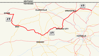
State Route 49 is a state highway in Tennessee. The route forms a broad southern arc that passes through the rural Middle Tennessee towns of Dover, Erin, Charlotte, Ashland City, Pleasant View, and Springfield.
State Route 126 is a 24.6-mile-long (39.6 km) state highway that travels through Sullivan County in East Tennessee. It connects Kingsport and Bristol.
State Route 50 (SR 50) is a west–to–east highway in Middle Tennessee. The road begins near Only and ends in Altamont. The current length is 161.3 miles (259.6 km).
State Route 370 is a 5.8 mile long north-south state highway in Union County, Tennessee. It connects the community of Potato Valley with the cities of Plainview and Maynardville.
