
Roane County is a county of the U.S. state of Tennessee. As of the 2020 census, the population was 53,404. Its county seat is Kingston. Roane County is included in the Knoxville, TN Metropolitan Statistical Area.

Meigs County is a county located in the U.S. state of Tennessee. As of the 2020 census, the population was 12,758. Its county seat is Decatur.

Decatur is a town in Meigs County, Tennessee, United States. The population was 1,563 at the 2020 census. It is the county seat of Meigs County.

Kingston is a city in and the county seat of Roane County, Tennessee, United States. This city is thirty-six miles southwest of Knoxville. It had a population of 5,934 at the 2010 United States census, and is included in the Harriman Micropolitan Statistical Area. Kingston is adjacent to Watts Bar Lake.
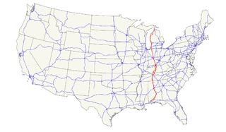
U.S. Route 27 (US 27) is a north–south United States Highway in the southern and midwestern United States. The southern terminus is at US 1 in Miami, Florida. The northern terminus is at Interstate 69 (I-69) in Fort Wayne, Indiana. From Miami it goes up the center of Florida, then west to Tallahassee, Florida, and north through such cities and towns as Columbus, Georgia; Rome, Georgia; Chattanooga, Tennessee; Lexington, Kentucky; Cincinnati, Ohio; Oxford, Ohio; Richmond, Indiana; and Fort Wayne, Indiana. It once extended north through Lansing, Michigan, to Cheboygan, Mackinaw City, and for about three years as far as St. Ignace. US 27 was first signed in 1926, replacing what had been the eastern route of the Dixie Highway in many states.
U.S. Route 31 or U.S. Highway 31 (US 31) is a major north–south U.S. highway connecting southern Alabama to northern Michigan. Its southern terminus is at an intersection with US 90/US 98 in Spanish Fort, Alabama. Its northern terminus is at an interchange with Interstate 75 (I-75) south of Mackinaw City, Michigan.
U.S. Route 72 (US 72) is an east–west United States highway that travels for 317.811 miles (511.467 km) from southwestern Tennessee, throughout North Mississippi, North Alabama, and southeastern Tennessee. The highway's western terminus is in Memphis, Tennessee and its eastern terminus is in Chattanooga. It is the only U.S. Highway to begin and end in the same state, yet pass through other states in between. Prior to the U.S. Highway system signage being posted in 1926, the entire route was part of the Lee Highway.
Ten Mile is an unincorporated community in northern Meigs and southeastern Roane counties in the U.S. state of Tennessee.
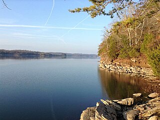
Watts Bar Lake is a reservoir on the Tennessee River created by Watts Bar Dam as part of the Tennessee Valley Authority system.

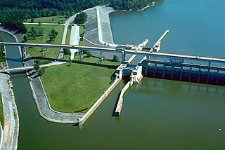
Watts Bar Dam is a hydroelectric dam on the Tennessee River in Meigs and Rhea counties in Tennessee, United States. The dam is one of nine dams on the main Tennessee River channel operated by the Tennessee Valley Authority, which built the dam in the early 1940s to provide flood control and electricity and to help create a continuous navigable channel along the entire length of the river. The dam is the technical boundary between the 39,090-acre (15,820 ha) Watts Bar Lake— which it impounds— and Chickamauga Lake, which stretches from the dam's tailwaters southward to Chattanooga.

Melton Hill Dam is a hydroelectric dam on the Clinch River just south of Oak Ridge, Tennessee, United States. The dam is operated by the Tennessee Valley Authority, which built the dam in the early 1960s to extend the Tennessee Valley's continuous navigation channel up the Clinch as far as Clinton and to increase TVA's overall power-generating capacity. The dam impounds the 5,470-acre (2,210 ha) Melton Hill Lake, and is the only TVA tributary dam serviced by a navigation lock. The dam and associated infrastructure were listed on the National Register of Historic Places in 2017.

U.S. Route 31 (US 31) in Alabama runs north–south up through the heart of Alabama for 386.449 miles (621.929 km). US 31 proper begins at a junction with US 90 and US 98 in Spanish Fort and exits the state into Tennessee running concurrently with Interstate 65 (I-65) near Ardmore. US 31 enters the limits of major cities Montgomery, Birmingham, and Decatur. Throughout the state, with the exception of its concurrency with I-65 north of Athens, US 31 runs concurrently with the unsigned State Route 3. Today, aside from portions through major towns and cities, US 31 is largely a rural two-lane highway. The route has largely been supplanted by I-65, with which it has eight junctions and two concurrencies.
State Route 2 is a 197-mile-long (317 km) west–to–east state highway in the U.S. state of Tennessee. It begins in Murfreesboro, in Rutherford County, and ends near Farragut in Loudon County. The route is both a primary and secondary route.
Chickamauga Lake is a reservoir in the United States along the Tennessee River created when the Chickamauga Dam, as part of the Tennessee Valley Authority, was completed in 1940. The lake stretches from Watts Bar Dam at mile 529.9 (853 km) to Chickamauga Dam at mile 471.0 (758 km) making the lake 58.9 miles (94.8 km) long. It borders Rhea County, Meigs County, and Hamilton County with 810 miles (1,303 km) of shoreline and two bridges crossing it at State Highway 60 and Highway 30. The lake is commonly used for recreational and outdoor activities, especially at the southern end, due to the high population density surrounding it. It was named after the Chickamauga Cherokee who used to live in the area.
State Route 20 (SR 20) is a 73.978-mile-long (119.056 km) state highway in the northern part of the U.S. state of Alabama. It travels from the Tennessee state line, where it continues as Tennessee State Route 69, northwest of Florence, east to Interstate 65 (I-65), east of Decatur. It crosses the Tennessee River at Florence and also at Decatur
State Route 58, also locally called "Highway 58", is a north–south state highway in the U.S. state of Tennessee that serves as a major route for many communities in Roane, Meigs, and Hamilton counties.
State Route 61 is a west-to-east highway in the U.S. state of Tennessee that is 81.67-mile-long (131.44 km). State Route 61 begins in Roane County, and it ends in Grainger County.
State Route 68 (SR 68) is a 106.89-mile-long (172.02 km) state highway in the eastern part of the U.S. state of Tennessee.
State Route 72 is a 43.3-mile-long (69.7 km) state highway in the eastern portion of U.S. state of Tennessee. It travels through the towns of Vonore and Loudon.
State Route 114 is a north–south state highway that traverses six counties in the western grand division of Tennessee. The 96.49-mile-long (155.29 km) route travels from Clifton Junction to an area south of Paris via Scotts Hill, Lexington, and the Natchez Trace State Park.
