State Route 2 is a 197-mile-long (317 km) west–to–east state highway in the U.S. state of Tennessee. It begins in Murfreesboro, in Rutherford County, and ends near Farragut in Loudon County.
State Route 22 is a 172.8-mile long (278.1 km) south-to-north state highway in the western part of the U.S. state of Tennessee. It begins at the Mississippi state line in McNairy County, where the roadway continues as Mississippi Highway 2. It ends at the Kentucky state line in Lake County, when it crosses into the Kentucky Bend, a detached portion of Fulton County, Kentucky.
State Route 58 , also locally called "Highway 58", is a north–south state highway in the U.S. state of Tennessee that serves as a major route for many communities in Roane, Meigs, and Hamilton counties.
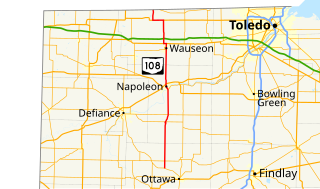
State Route 108 (SR 108) is a 49.30-mile (79.34 km) state route that runs between SR 15 and the Michigan state line in the US state of Ohio. Most of the route is a rural two-lane highway and passes through both farmland and residential properties.

State Route 109 (SR 109) is a 52.9-mile (85.1 km) state route that runs between Ottawa and the Michigan state line in the US state of Ohio. It crosses a major river, the Maumee, east of Napoleon. Most of the route is a rural two-lane highway and passes through both farmland and residential properties.
State Route 266 (SR 266) is a 14-mile-long (23 km) east–west state highway located in the southeastern portion of Ohio. SR 266's western terminus is at an intersection with SR 377 nearly 3 1⁄2 miles (5.6 km) northwest of Stockport, and its eastern terminus is an intersection with SR 60 approximately 4 1⁄2 miles (7.2 km) northwest of Beverly.

State Route 77 is a 103-mile-long (166 km) state highway that runs nouth-to-sorth through portions of Hancock, Greene, Oglethorpe County, Elbert, and Hart Counties in the eastern part of the State of Georgia.

State Route 56 (SR 56), also known as the Mike Padgett Highway, is a 140.3-mile-long (225.8 km) state highway that travels south-to-north in an upside down question mark, with a western loop around Vidalia. It travels through portions of Tattnall, Toombs, Montgomery, Treutlen, Emanuel, Burke, and Richmond counties in the southeastern and east-central parts of the U.S. state of Georgia. The route connects the Reidsville and Augusta areas, via Swainsboro and Waynesboro.
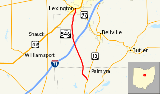
State Route 546 is a north–south state highway in the northern portion of the U.S. state of Ohio. The southern terminus of SR 546 is at a T-intersection with SR 13 nearly two and a half miles (4.0 km) north of Fredericktown. Its northern terminus is at a signalized intersection with the U.S. Route 42 (US 42)/SR 97 concurrency in Lexington.

State Route 684 is a short north–south state highway in the southern portion of Ohio. Its southern terminus is at State Route 143 in the unincorporated community of Harrisonville, and its northern terminus is at State Route 681 near the community of Pageville.
State Route 122 (SR 122) is a 3.777-mile-long (6.078 km) state highway in Coffee County in the southern part of the U.S. state of Alabama. The western terminus of the highway is at an intersection with U.S. Route 84 (US 84) at New Brockton. The eastern terminus of the highway is at an intersection with SR 51 north of Enterprise.

State Route 282 is a north–south state highway in northeastern Ohio, a U.S. state. The southern terminus of SR 282 is at a T-intersection with SR 305 near the hamlet of Nelson. Its northern terminus is also at a T-intersection, this time with the four-lane divided U.S. Route 422 (US 422) approximately two miles (3.2 km) southeast of Parkman. SR 282 primarily serves as an access route for Nelson Kennedy Ledges State Park. For its duration, the highway is also known as Nelson Ledge Road.
State Route 60 is a north-south major state route in Eastern Tennessee. It covers 54 miles (87 km) and runs from the Tennessee-Georgia state line in Bradley County, Tennessee to Dayton joining US 27.
State Route 55 is an east-west highway in Middle Tennessee. The road begins at SR 50 in Lynchburg and ends at U.S. Route 70S and SR 380 in McMinnville. The current length is 49.3 mi (79.3 km). SR 55 heads northeast from Lynchburg to Tullahoma as a two-lane road. In Tullahoma, the route runs concurrent with US 41A. From here, SR 55 heads northeast as a multilane highway to Manchester, where it intersects US 41 and Interstate 24 (I-24). The route continues northeast, serving Summitville and Morrison before it reaches McMinnville.
State Route 80 (SR 80) is a 84.0-mile-long (135.2 km) state highway that predominantly travels in a west–east direction in the east central part of the U.S. state of Georgia. It exists within portions of Wilkes, Warren, Glascock, Jefferson, and Burke counties.
State Route 111 (SR 111) is a state highway in the southwest part of the U.S. state of Georgia. The highway runs 54.8 miles (88.2 km) from the Florida state line, southwest of Calvary northeast through Cairo and Meigs, glancing off the northwest corner of Riverside, and ending in Moultrie.
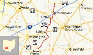
State Route 729 is a state highway in central Ohio. The 33.58-mile-long (54.04 km) route runs from SR 73 and SR 350 in the community of Snow Hill, northwest of New Vienna to SR 323 north of Jeffersonville.
State Route 68 (SR 68) is a 106.89-mile-long (172.02 km) state highway in the eastern part of the U.S. state of Tennessee.
State Route 105 is 44.34-mile-long (71.36 km) east–west state highway in West Tennessee. It traverses mainly rural areas and farmland.


