Tennessee State Route 30

Last updated

Tennessee 30.svg Secondary Tennessee 30.svg

State Route 30

TNSR30.jpg
SR 30 highlighted
Route information
Maintained by TDOT
Length118.15 mi (190.14 km)
ExistedOctober 1, 1923 [1] –present
Major junctions
West endUS 70S.svg US 70S near McMinnville
Major intersectionsUS 127.svg US 127 in Pikeville
US 27.svg US 27 in Dayton
I-75.svg I-75 in Athens
US 411.svg US 411 in Etowah
East endUS 64.svgUS 74.svg US 64  / US 74 in the Cherokee National Forest
Location
Country United States
State Tennessee
Counties Warren, Van Buren, Bledsoe, Rhea, Megis, McMinn, Polk
Highway system
Tennessee 29.svg SR 29 US 31.svg US 31

State Route 30 (SR 30) is an east-west state highway in the central and eastern portions of the U.S. state of Tennessee. It runs generally west to east, connecting McMinnville in Warren County with Parksville along the Ocoee River in Polk County. It crosses several major geographic features in Tennessee, including the Cumberland Plateau, the Sequatchie Valley, the Tennessee River, and parts of the Cherokee National Forest.

Contents

TN SR 30 highlighted in bold black TNSR30.jpg
TN SR 30 highlighted in bold black

Route description

SR 30 begins just east of McMinnville in Warren County at an intersection with US 70S. Just beyond this initial junction, SR 30 intersects SR 127, which connects the area to Tullahoma to the southwest. SR 30 continues eastward, crossing into Van Buren County at the Rocky River. After passing several miles through predominantly-rural western Van Buren, the highway ascends over 900 feet (270 m) through a series of switchback curves to the top of the Cumberland Plateau, where it enters the town of Spencer. [2] Following College Street through Spencer, SR 30 intersects SR 111 just east of the town's downtown area. [3]

Continuing east beyond Spencer, SR 30 descends more than 900 feet (270 m) from the edge of the plateau into the Dry Fork Gulf. [4] This area marks the outer reaches of Fall Creek Falls State Park. At the base of the valley, SR 30 crosses Cane Creek and joins SR 285, which approaches from further down the valley in the direction of Doyle. The merged highway then continues eastward, reascending more than 800 feet (240 m) back to the top of the plateau, [4] before SR 285 diverges northward, and SR 30 continues toward the east. Just before reaching the Van Buren-Bledsoe county line, SR 30 intersects SR 284, which provides the primary access to Fall Creek Falls State Park to the south. [3]

SR 30 in Spencer Spencer-Old-Times-Cafe-tn1.jpg
SR 30 in Spencer

In the Mount Crest area of western Bledsoe, SR 30 intersects SR 101, which runs in a northeastward direction to Crossville. Just past Mount Crest, SR 30 begins another significant elevation change, this time descending more than 1,000 feet (300 m) from the edge of Cumberland Plateau into the Sequatchie Valley. [5] This particularly steep section of the highway endures occasional closures due to rockslides. [6] In Pikeville, SR 30 merges with the north-south-oriented US 127. This merged route travels along the east side of Pikeville before the two highways split just south of the downtown area, with US 127 continuing southward to Dunlap, and SR 30 crossing the Sequatchie River before turning east. [3]

Continuing across the relatively narrow Sequatchie Valley, SR 30 begins another ascent of the Cumberland Plateau, climbing more than 1,000 feet (300 m) before topping out near Summer City. [7] After traversing this section of the plateau, known as Walden Ridge, and crossing into Rhea County, SR 30 enters its final major elevation change, this time winding its way more than 1,200 feet (370 m) down the side of the Cumberland Plateau into the Tennessee Valley. [8] In Dayton, SR 30 intersects US 27, which connects Dayton with Chattanooga to the south. [3]

After crossing the Tennessee River east of Dayton, SR 30 continues winding its away around the various ridges and valleys that characterize the region, and passes through the county seats of Decatur and Athens. In the latter city, SR 30 crosses I-75 and US 11, both of which run northeastward to Knoxville and southwestward to Chattanooga. In Etowah in eastern McMinn County, SR 30 merges with US 411, and veers southward into Polk County. The highway provides access to Hiwassee/Ocoee Scenic River State Park (via Spring Creek Road) before crossing the Hiwassee River, with SR 30 splitting off from US 411 less than a mile later, turning eastward up the Hiwassee Valley into the Cherokee National Forest. [3]

In the old community of Reliance, SR 30 intersects SR 315, which runs northward in the direction of Tellico Plains. Just past this junction, SR 30 turns sharply to the south, and winds its way into the Greasy Creek Valley. The highway follows this valley southwestward to the Parksville area along the Ocoee River, where it terminates at US 64 and US 74. [3]

Major intersections

CountyLocationmikmDestinationsNotes
Warren 0.00.0US 70S.svg US 70S (Sparta Highway/SR 1) McMinnville, Doyle, Sparta Western terminus; SR 30 begins as a primary highway
South plate.svg
Secondary Tennessee 127.svg
SR 127 south (Shellsford Road) McMinnville, Viola
Northern terminus of SR 127
Van Buren Spencer Tennessee 111.svg SR 111 (Artillery Road) Sparta, Dunlap Interchange
West plate.svg
Secondary Tennessee 285.svg
SR 285 west (Cane Creek-Cummingsville Road) Doyle
Western end of SR 285 concurrency
East plate.svg
Secondary Tennessee 285.svg
SR 285 east (Mooneyham Road)
Eastern end of SR 285 concurrency
Bledsoe West plate.svg
Secondary Tennessee 284.svg
SR 284 west (Park Road) Fall Creek Falls State Park
Eastern terminus of SR 284
Mount Crest North plate.svg
Secondary Tennessee 101.svg
SR 101 north (Lantana Road) Lake Tansi Village, Crossville
Southern terminus of SR 101
Pikeville North plate.svg
US 127.svg
US 127 north (Alvin C. York Highway/SR 28 north) Crossville
Western end of US 127/SR 28 concurrency
South plate.svg
US 127.svg
US 127 south (Alvin C. York Highway/SR 28 south) Dunlap
Eastern end of US 127/SR 28 overlap
Bridge over the Sequatchie River
Summer City East plate.svg
Secondary Tennessee 443.svg
SR 443 east (New Harmony Road) New Harmony
Western terminus of SR 443
Rhea West plate.svg
Secondary Tennessee 443.svg
SR 443 west (Ogden Road) Ogden
Eastern terminus of SR 443
South plate.svg
Secondary Tennessee 303.svg
SR 303 south (Cranmore Cove Road) Graysville
Northern terminus of SR 303
Dayton North plate.svg
Secondary Tennessee 378.svg
SR 378 north (Market Street)
Western end of SR 378 concurrency
South plate.svg
Secondary Tennessee 378.svg
SR 378 south (Market Street)
Eastern end of SR 378 concurrency
US 27.svg US 27 (Rhea County Highway/SR 29) Chattanooga, Soddy-Daisy, Spring City
Old Washington North plate.svg
Secondary Tennessee 302.svg
SR 302 north (Old Dixie Highway) Spring City
Southern terminus of SR 302
Tennessee River Washington Ferry Bridge over the Tennessee River
Meigs Decatur Tennessee 58.svg SR 58 (Meigs County Highway) Kingston, Georgetown, Chattanooga
McMinn Athens I-75.svg I-75  Chattanooga, Knoxville I-75 exit 49
US 11.svg US 11 (Congress Parkway/SR 2) Cleveland, Calhoun, Charleston, Niota, Sweetwater
Business plate.svg
US 11.svg
US 11 Bus. (N Jackson Street) – Downtown
West plate.svg
Secondary Tennessee 39.svg
SR 39 west (E Washington Avenue/E Madison Avenue) – Downtown, Riceville
one-way pair; western end of SR 39 concurrency
North plate.svg
Secondary Tennessee 305.svg
North plate.svg
Secondary Tennessee 307.svg
To plate blue.svg
I-75.svg
SR 305 north (Ingleside Avenue) / SR 307 north (E Madison Avenue) to I-75  Sweetwater
Southern terminus of SR 305 and SR 307
East plate.svg
Secondary Tennessee 39.svg
SR 39 east (New Englewood Road) Englewood
Eastern end of SR 39 concurrency
Etowah North plate.svg
US 411.svg
US 411 north (Tennessee Avenue/SR 33 north) Englewood
Western end of US 411/SR 33 concurrency
East plate.svg
Tennessee 310.svg
SR 310 east (Mecca Pike) Tellico Plains
Western terminus of SR 310
Polk Delano West plate.svg
Secondary Tennessee 163.svg
To plate blue.svg
I-75.svg
SR 163 west (Bowater Road) to I-75  Calhoun
Eastern terminus of SR 163
Bridge over the Hiwassee River
South plate.svg
US 411.svg
US 411 south (SR 33 south) Benton
Eastern end of US 411/SR 33 concurrency; SR 30 turns secondary
Reliance North plate.svg
Secondary Tennessee 315.svg
SR 315 north (Reliance Road) Tellico Plains
Southern terminus of SR 315
Cherokee National Forest 118.15190.14US 64.svgUS 74.svg US 64  / US 74 (Ocoee Scenic Byway/SR 40) Cleveland, Ocoee, Ducktown Eastern terminus; SR 30 ends as a secondary highway
1.000 mi = 1.609 km; 1.000 km = 0.621 mi

Related Research Articles

<span class="mw-page-title-main">Sequatchie County, Tennessee</span> County in Tennessee, United States

Sequatchie County is a county located in the U.S. state of Tennessee. As of the 2020 census, the population was 15,826. Its county seat is Dunlap. Sequatchie County is part of the Chattanooga, TN–GA Metropolitan Statistical Area.

<span class="mw-page-title-main">Pikeville, Tennessee</span> City in Tennessee, United States

Pikeville is a city in Bledsoe County, Tennessee, United States. The population was 2,251 at the 2010 census. It is also the county seat of Bledsoe County.

<span class="mw-page-title-main">Dunlap, Tennessee</span> City in Tennessee, United States

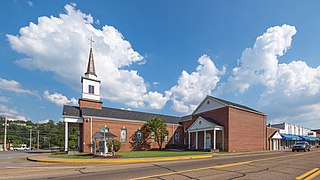
Dunlap is a city in and the county seat of Sequatchie County, Tennessee, United States. The population was 5,357 at the 2020 census and 4,815 at the 2010 census.

<span class="mw-page-title-main">East Tennessee</span> Geographic and cultural region of Tennessee, United States

East Tennessee is one of the three Grand Divisions of Tennessee defined in state law. Geographically and socioculturally distinct, it comprises approximately the eastern third of the U.S. state of Tennessee. East Tennessee consists of 33 counties, 30 located within the Eastern Time Zone and three counties in the Central Time Zone, namely Bledsoe, Cumberland, and Marion. East Tennessee is entirely located within the Appalachian Mountains, although the landforms range from densely forested 6,000-foot (1,800 m) mountains to broad river valleys. The region contains the major cities of Knoxville and Chattanooga, Tennessee's third and fourth largest cities, respectively, and the Tri-Cities, the state's sixth largest population center.

<span class="mw-page-title-main">Calfkiller River</span> River in Tennessee, United States

The Calfkiller River is a 42.4-mile-long (68.2 km) stream in the east-central portion of Middle Tennessee in the United States. It is a tributary of the Caney Fork, and is part of the Cumberland, Ohio, and Mississippi watersheds. The river is believed to be named for a Cherokee chief who once lived in the area.

<span class="mw-page-title-main">Collins River</span> River in Tennessee, United States

The Collins River is a 67-mile-long (108 km) stream in the east-central portion of Middle Tennessee in the United States. It is a tributary of the Caney Fork, and is part of the Cumberland, Ohio and Mississippi watersheds. The river drains the scenic Savage Gulf area, located just below the river's source, and empties into Great Falls Lake at Rock Island State Park.

<span class="mw-page-title-main">Rocky River (Tennessee)</span> River in Tennessee, United States

The Rocky River is a 31.0-mile-long (49.9 km) stream in the east-central portion of Middle Tennessee in the United States. It is a tributary of the Caney Fork River, and is part of the Cumberland, Ohio and Mississippi watersheds. The lower portion of the river is part of the reservoir created by Great Falls Dam, which is located near the river's confluence with the Caney Fork.

<span class="mw-page-title-main">Sequatchie River</span> River in Tennessee, United States

The Sequatchie River is a 116-mile-long (187 km) waterway that drains the Sequatchie Valley, a large valley in the Cumberland Plateau in Tennessee. It empties into the Tennessee River downstream from Chattanooga near the Tennessee-Alabama state line.

<span class="mw-page-title-main">U.S. Route 411</span> Numbered U.S. Highway in Alabama, Georgia, and Tennessee in the United States

U.S. Route 411 (US 411) is an alternate parallel-highway associated with US 11. It extends for about 309.7 miles (498.4 km) from US 78 in Leeds, Alabama, to US 25W/US 70 in Newport, Tennessee. US 411 travels through northeastern Alabama, northwestern Georgia, and southeastern Tennessee. It is signed north-south, as with most highways that have odd numbers, but the route runs primarily in a northeast-southwest direction, and covers a more east-west mileage than it does north-south. Notable towns and cities along its route include Gadsden, Alabama; Rome, Georgia; Cartersville, Georgia; Maryville, Tennessee; Sevierville, Tennessee, and Newport, Tennessee.

<span class="mw-page-title-main">Tennessee State Route 2</span> State highway in Tennessee, United States

State Route 2 is a 197-mile-long (317 km) west–to–east state highway in the U.S. state of Tennessee. It begins in Murfreesboro, in Rutherford County, and ends near Farragut in Loudon County. The route is both a primary and secondary route. Most of the route is unsigned.

<span class="mw-page-title-main">Tennessee State Route 58</span>

State Route 58, also locally called "Highway 58", is a north–south state highway in the U.S. state of Tennessee that serves as a major route for many communities in Roane, Meigs, and Hamilton counties.

<span class="mw-page-title-main">Sequatchie Valley</span>

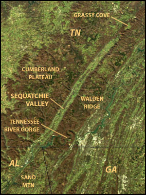
Sequatchie Valley is a relatively long and narrow valley in the U.S. state of Tennessee and, in some definitions, Alabama. It is generally considered to be part of the Cumberland Plateau region of the Appalachian Mountains; it was probably formed by erosion of a compression anticline, rather than rifting process as had been formerly theorized.

<span class="mw-page-title-main">U.S. Route 27 in Tennessee</span> United States Numbered Highway in Tennessee

U.S. Route 27 in Tennessee runs from the Georgia state line in Chattanooga to the Kentucky state line in Isham. It forms the informal border between the Eastern and Central Time Zones of the state. However, it stays in the Eastern Time Zone.

<span class="mw-page-title-main">Tennessee State Route 8</span> Highway in Tennessee

State Route 8 is a 75.43-mile-long (121.39 km) north–south state highway in East and Middle Tennessee. It connects the cities of Chattanooga and McMinnville via Signal Mountain and Dunlap.

<span class="mw-page-title-main">U.S. Route 64 in Tennessee</span>

In Tennessee, U.S. Route 64 stretches 404.1 miles (650.3 km) from the Mississippi River in Memphis to the North Carolina state line near Ducktown. The highway, along with US 72, is a major route for travel between Memphis and Chattanooga.

<span class="mw-page-title-main">U.S. Route 127 in Tennessee</span> Highway in Tennessee, United States

U.S. Route 127 in Tennessee is a 129.5-mile-long (208.4 km) United States Numbered Highway from Chattanooga to the Kentucky state line at Static. The highways connects through Dunlap, Pikeville, Crossville, and Jamestown. Throughout its length, US 127 straddles the line between East Tennessee and Middle Tennessee.

<span class="mw-page-title-main">Tennessee State Route 111</span> State highway in Tennessee, United States

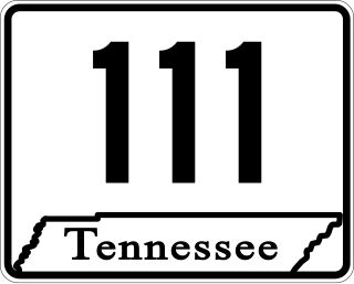
State Route 111 (SR 111) is a north–south highway in Middle and East Tennessee. The road begins in Soddy-Daisy and ends north of Byrdstown in the community of Static, at the Tennessee/Kentucky state line. The length is 116 mi (186.7 km).

<span class="mw-page-title-main">Tennessee State Route 33</span> State highway in Tennessee, United States

State Route 33 is a primary and secondary route in East Tennessee. It runs 176 miles, from the Georgia state line in Polk County, northeast to the Virginia state line north of Kyles Ford in Hancock County. South of Maryville, SR 33 is a "hidden" route which shares a concurrency with US 411.

<span class="mw-page-title-main">Tennessee State Route 156</span> State highway in Franklin and Marion counties in Tennessee, United States

State Route 156 is a spur route of Tennessee State Route 56 (SR 56) and a state highway in Franklin and Marion counties in the southern central and southeastern portions of Tennessee, United States. It traverses the southern Cumberland Plateau before descending into the Sequatchie Valley, where follows the shores of Nickajack Lake for its final few miles.

<span class="mw-page-title-main">Tennessee State Route 28</span> State highway in Tennessee, United States

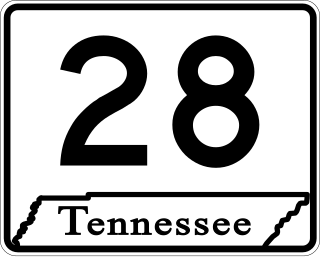
State Route 28 is a state highway in the state of Tennessee, traversing the state in a north–south axis from south of Jasper to the Kentucky state line at Static.

References

  1. Highway Planning Survey Division (1925). Biennial Report of the Commissioner of the Department of Highways and Public Works State of Tennessee for the Years 1923 and 1924 (PDF) (Report). Nashville: Tennessee Department of Highways and Public Works. pp. 39–44. Retrieved May 19, 2023.
  2. U.S. Geological Survey. Spencer, TN. 1:24,000.
  3. 1 2 3 4 5 6 Tennessee Department of Transportation (2016). Official Transportation Map (PDF) (Map). c.1:1,013,760. Nashville: Tennessee Department of Transportation. §§ C10-C11, D11-D12, E12. Retrieved June 29, 2016.
  4. 1 2 U.S. Geological Survey. Bald Knob, TN. 1:24,000.
  5. U.S. Geological Survey. Billingsley Gap, TN. 1:24,000.
  6. Ben Burton, "Road Repairs to Close State Highway 30 Between Pikeville and Fall Creek Falls," Chattanooga Times Free Press, 17 June 2016.
  7. U.S. Geological Survey. Pikeville, TN. 1:24,000.
  8. U.S. Geological Survey. Morgan Springs, TN. 1:24,000.

Commons-logo.svg Media related to Tennessee State Route 30 at Wikimedia Commons