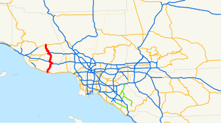
State Route 23 is a state highway in the U.S. state of California that connects the Pacific coast and the Santa Monica Mountains to the Conejo and Santa Clara River valleys. It runs from Pacific Coast Highway in Malibu in Los Angeles County to Ventura Street in Fillmore in Ventura County.

State Route 186, also known as Algodones Road, is a state highway in the U.S. state of California that connects Interstate 8 (I-8) in Imperial County with the U.S.–Mexico border near the Colorado River. Its southern terminus is at the Andrade Port of Entry, which connects it to Los Algodones, Baja California, and its northern terminus is near Winterhaven, California in the location of Araz Junction. The route is only 2.070 miles (3.331 km) long, heading along the length of the Alamo Canal and the All-American Canal within the boundaries of the Fort Yuma-Quechan Reservation. The route was assigned in 1972 in Imperial County, and the interchange with I-8 was constructed a year later.
New York State Route 295 (NY 295) is a 12.88-mile (20.73 km) state highway in Columbia County, New York, in the United States. It begins at an intersection with NY 66 in the village of Chatham and heads generally easterly to the Massachusetts border in the town of Canaan, where the road becomes Massachusetts Route 295 for another 1.67 miles (2.69 km) to a junction with Route 41 in Richmond, Massachusetts. Route 295 is the highest numbered Massachusetts state highway.

State Route 299 (SR 299) is a short west-east state highway located in the northwestern part of the U.S. state of Georgia. Its route is entirely within Dade County.
State Route 157 (SR 157) is a 91.061-mile-long (146.548 km) state highway in the northern and northwestern parts of the U.S. state of Alabama. The southern terminus of the highway is at an intersection with U.S. Route 278 (US 278) approximately 10 miles (16 km) east of Cullman, where it continues as County Road 719.The northern terminus of the highway is at the Tennessee state line northwest of Florence. SR 157 continues as Tennessee State Route 227 (SR 227) once it crosses into Tennessee.
State Route 65 (SR 65) is a 27.540-mile-long (44.321 km) state highway in western Jackson County, in the U.S. state of Alabama. The southern terminus of the highway is at an intersection with U.S. Route 72 (US 72) at Paint Rock. The northern terminus of the highway is at the Tennessee state line, north of Francisco. North of the state line, the highway continues as Tennessee State Route 97.
State Route 476 is a state highway in Tennessee designated in 2007, located north and west of Winchester. It was created as an access road to Tims Ford Lake, which it crosses twice, and Tims Ford State Park. The route is located entirely in Franklin County, Tennessee.
Below is a list and summary of the former state highways.

State Route 119 (SR 119) is an 81.2-mile-long (130.7 km) state highway that runs south-to-north in the east-central part of the U.S. state of Georgia. It runs from Riceboro to the Hinesville – Fort Stewart metropolitan area and curves to the northeast, through Pembroke and Springfield, and enters South Carolina north of Clyo, where the roadway continues as South Carolina Highway 119.
U.S. Route 79 in Tennessee enters the state from Arkansas via the Memphis & Arkansas Bridge in Memphis, and runs northeast through western and the northwestern portions of middle Tennessee, and leaving the state into Kentucky northeast of Clarksville. Along the route, US 79 is accompanied with several concurrencies, including hidden designations, throughout its alignment in Tennessee.
U.S. Route 129 is a north–south United States highway that runs for 52.8 miles (85.0 km) in East Tennessee, from the North Carolina state line, near Tapoco, to Knoxville. In Tennessee, the highway is completely overlapped by unsigned State Route 115.
State Route 111 (SR 111) is a north–south highway in Middle and East Tennessee. The road begins in Soddy-Daisy and ends north of Byrdstown in the community of Static, at the Tennessee/Kentucky state line. The length is 118.72 mi (191.1 km).
State Route 49 is a state highway in Tennessee. The route forms a broad southern arc that passes through the rural Middle Tennessee towns of Dover, Erin, Charlotte, Ashland City, Pleasant View, and Springfield.
At least 13 special routes of U.S. Route 11 and at least one of U.S. Route 11E have existed.
State Route 220 is a 14.2-mile-long (22.9 km) state highway that travels entirely within Carroll County in West Tennessee.
The Woodlands Trace National Scenic Byway, also known as "The Trace," is the major north–south roadway that traverses the Land Between the Lakes National Recreation Area in two counties in western Kentucky and northwestern Stewart County in northwest Middle Tennessee. It is estimated to be 43.1 miles (69.4 km) in length. The road is part of the National Scenic Byway system. Although it is not signed, it is listed on LBL's road logs as FD-100.
State Route 260 (SR 260), also known as Browning Branch Road, is an east–west secondary highway that is located entirely in Trousdale County in Middle Tennessee, United States. Its western terminus is located at a junction with US 231 near the Sumner County line, and it ends at SR 141 just north of Hartsville.
State Route 38 is a north–south highway located entirely in Hamilton County in southern East Tennessee. The 2.96-mile (4.76 km) highway runs concurrently with U.S. Route 11 for its entire length from the Georgia state line to the US 41/US 64/US 72 in west Chattanooga.
State Route 320 is a west-east state highway located entirely in Hamilton County in southeastern Tennessee. it traverses mainly the eastern portions of the county, including Chattanooga’s eastern outskirts and the census designated place of East Brainerd.
