
Veracruz, formally Veracruz de Ignacio de la Llave, officially the Free and Sovereign State of Veracruz de Ignacio de la Llave, is one of the 32 states which comprise the Federal Entities of Mexico. It is divided in 212 municipalities and its capital city is Xalapa-Enríquez.

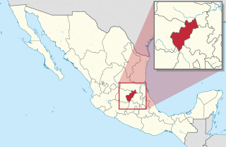
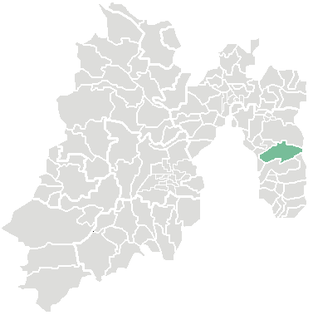
The State of Mexico is one of the 32 federal entities of Mexico. It is the most populous, as well as the most densely populated state. It is divided into 125 municipalities and its capital city is Toluca de Lerdo.
Querétaro, officially the Free and Sovereign State of Querétaro, formally Querétaro de Arteaga), is one of the 32 federal entities of Mexico. It is divided into 18 municipalities. Its capital city is Santiago de Querétaro.

Tamaulipas, officially the Estado Libre y Soberano de Tamaulipas, is one of the 32 states which comprise the Federal Entities of Mexico. It is divided into 43 municipalities and its capital city is Ciudad Victoria.

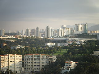
Cuautitlán Izcalli is a city and municipality in the north of State of Mexico, Mexico. The name comes from Náhuatl and means 'your house among the trees.'

Guanajuato, officially the Free and Sovereign State of Guanajuato, is one of the 32 states which make up the Federal Entities of Mexico. It is divided into 46 municipalities and its capital city is Guanajuato. The largest city in the state is León.

Naucalpan, officially Naucalpan de Juárez, is a city and municipality located just northwest of Mexico City in the adjoining State of Mexico.

Municipalities are the second-level administrative divisions of Mexico, where the first-level administrative division is the state. As of the establishment of two new municipalities in Chiapas in September 2017, there are 2,448 municipalities in Mexico, not including the 16 delegaciones of Mexico City. The internal political organization and their responsibilities are outlined in the 115th article of the 1917 Constitution and detailed in the constitutions of the states to which they belong. Municipalities are distinct from cities, a form of Mexican locality; some municipalities as large as states, while cities can be measured in city blocks.
Ixtapaluca is a city and a municipality in the eastern part of the State of Mexico in Mexico. It lies between the Federal District and the western border of the state of Puebla. The name Ixtapaluca means "Where the salt gets wet".
Huixquilucan Municipality is one of the municipalities in State of Mexico, Mexico. It lies adjacent to the west side of the Federal District and is part of Greater Mexico City but independent of. The name "Huixquilucan" comes from Nahuatl meaning, "place full of edible thistles."
Aculco is a municipality located in the Atlacomulco Region of the State of Mexico in Mexico. The municipality is located to northwestern Mexico State. The name comes from Nahuatl. The municipal seat is the town of Aculco de Espinoza, although both the town and municipality are commonly referred to as simply "San Jerónimo Aculco".

Jalisco, officially the Free and Sovereign State of Jalisco is one of the 32 states which comprise the Federal Entities of Mexico. It is located in Western Mexico and is bordered by six states which are Nayarit, Zacatecas, Aguascalientes, Guanajuato, Michoacán, and Colima. Jalisco is divided into 125 municipalities, and its capital city is Guadalajara. Jalisco is one of the most important states in Mexico because of its natural resources as well as its history. Many of the characteristic traits of Mexican culture, particularly outside Mexico City, are originally from Jalisco, such as mariachi, ranchera music, birria, tequila, jaripeo, etc., hence the state's motto: "Jalisco es México." Economically, it is ranked third in the country, with industries centered in the Guadalajara metropolitan area, the second largest metropolitan area in Mexico. The state is home to two significant indigenous populations, the Huichols and the Nahuas. There is also a significant foreign population, mostly from the United States and Canada, living in the Lake Chapala and Puerto Vallarta areas.

Pilcaya is one of the 81 municipalities of Guerrero, in south-western Mexico. The municipal seat lies at Pilcaya. The municipality covers an area of 62.1 km².

Tecpan de Galeana is one of the 81 municipalities of Guerrero, in south-western Mexico. The municipal seat lies at Tecpan de Galeana. The municipality covers an area of 2,537.8 km2 (979.9 sq mi).
Xochistlahuaca Municipality is one of the 81 municipalities of Guerrero, in south-western Mexico. The municipal seat lies at Xochistlahuaca. The municipality covers an area of 321.1 km².
Pilcaya is a town and municipality of state of Guerrero, Mexico, located 153 kilometres (95 mi) from Mexico City, 105 kilometres (65 mi) from Cuernavaca, 84 kilometres (52 mi) from Toluca, 68 kilometres (42 mi) from Taxco and 5 kilometres (3 mi) from Ixtapan de la Sal. The name "Pilcaya" is from the Nahuatl word pilcacyan, place of a hanging object.

Huaquechula Municipality is a municipality in Puebla in south-eastern Mexico.

Puebla Municipality is a municipality in the State of Puebla in eastern Central Mexico. The municipality covers a total area of 534.32 square kilometres (206.30 sq mi). The City of Puebla is the municipal seat, as well as the capital of the state.
Tepeaca Municipality is a municipality in Puebla in southeastern Mexico. Tepeaca is located 35 km (21.75 mi) from Puebla City and is the municipal seat of the municipality of the same name. Its name comes from a Spanish variant of "Tepeyacac" composed of the Nahuatl words tepetl ("hill") and yacatl. It has been called Tepeaca de Negrete as it was the birthplace and hometown of General Miguel Negrete Novoa. Along with Tecali Herrera, he extracted the onyx and marble. The town was originally founded by Hernán Cortés as Segura de la Frontera.
