Coixtlahuaca District

Last updated
Coixtlahuaca District
District
Oaxaca regions and districts.svg
Oaxaca regions and districts: Mixteca to Northwest
Coordinates: 17°43′N97°19′W / 17.717°N 97.317°W / 17.717; -97.317
CountryFlag of Mexico.svg  Mexico
State Oaxaca
Area
  Total 1,666 km2 (643 sq mi)
Population (2005)
  Total 9,018

Coixtlahuaca District is located in the northeast of the Mixteca Region of the State of Oaxaca, Mexico. As of 2005 the population was 9,018, down 2.8% from 2000. [1]

Oaxaca State of Mexico

Oaxaca, officially the Free and Sovereign State of Oaxaca, is one of the 31 states which, along with Mexico City, make up the 32 federative entities of Mexico. It is divided into 570 municipalities, of which 418 are governed by the system of usos y costumbres with recognized local forms of self-governance. Its capital city is Oaxaca de Juárez.

Mexico country in the southern portion of North America

Mexico, officially the United Mexican States, is a country in the southern portion of North America. It is bordered to the north by the United States; to the south and west by the Pacific Ocean; to the southeast by Guatemala, Belize, and the Caribbean Sea; and to the east by the Gulf of Mexico. Covering almost 2,000,000 square kilometres (770,000 sq mi), the nation is the fifth largest country in the Americas by total area and the 13th largest independent state in the world. With an estimated population of over 120 million people, the country is the eleventh most populous state and the most populous Spanish-speaking state in the world, while being the second most populous nation in Latin America after Brazil. Mexico is a federation comprising 31 states and Mexico City, a special federal entity that is also the capital city and its most populous city. Other metropolises in the state include Guadalajara, Monterrey, Puebla, Toluca, Tijuana and León.

Contents

The region is generally from 2,000m to 3,000m high, mostly hilly or mountainous with small plains. Temperatures range from 3°C to 36°C. Much of the area has been deforested and rainfall has decreased in recent years, affecting production of the standard crops of corn, wheat, beans and barley. It is the traditional home of the Chocho people, although they are now a small minority. The population has been shrinking due to emigration for economic reasons. [2]

Chocho language language

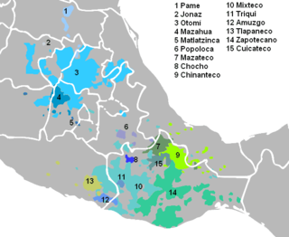
Chocho is a language of the Popolocan branch of the Oto-Manguean language family spoken in Mexico in the following communities of Oaxaca: Santa María Nativitas, San Juan Bautista Coixtlahuaca, San Miguel Tulancingo. Chocho is Spoken by 770 speakers.

Municipalities

Coixtlahuaca municipalities Coixtlahuaca municipalities.svg
Coixtlahuaca municipalities

The district includes the following municipalities: [3]

Concepción Buenavista Municipality and town in Oaxaca, Mexico

Concepción Buenavista is a town and municipality in Oaxaca in south-western Mexico. The municipality covers an area of 357.23 km². It is part of the Coixtlahuaca district in the Mixteca Region.

San Cristóbal Suchixtlahuaca Municipality and town in Oaxaca, Mexico

San Cristóbal Suchixtlahuaca is a town and municipality in Oaxaca in south-western Mexico. The municipality covers an area of 44.65 km². It is part of the Coixtlahuaca District in the Mixteca Region.

San Francisco Teopan Municipality and town in Oaxaca, Mexico

San Francisco Teopan is a town and municipality in Oaxaca in south-western Mexico. The municipality covers an area of 45.93 km². It is part of the Coixtlahuaca District in the Mixteca Region.

See also

Related Research Articles

San Juan Bautista Coixtlahuaca Municipality and town in Oaxaca, Mexico

San Juan Bautista Coixtlahuaca is a small town and municipality located in the Mixteca Region of the State of Oaxaca, Mexico, and the center of the Coixtlahuaca district. The name, “Coixtlahuaca” means ‘plain of snakes’ in the Nahuatl language.

San Miguel Tulancingo Municipality and town in Oaxaca, Mexico

San Miguel Tulancingo is a town and municipality in Oaxaca in south-western Mexico. The municipality covers an area of 53.59 square kilometres (20.69 sq mi). It is part of the Coixtlahuaca district in the Mixteca Region.

Santiago Ihuitlán Plumas Municipality and town in Oaxaca, Mexico

Santiago Ihuitlán Plumas is a town and municipality in Oaxaca in south-western Mexico. The municipality covers an area of km². It is part of the Coixtlahuaca District in the Mixteca Region.

Santiago Tenango is a town and municipality in Oaxaca in south-western Mexico. The municipality covers an area of 196.48 km². It is part of the Etla District in the Valles Centrales region.

Santiago Tepetlapa Municipality and town in Oaxaca, Mexico

Santiago Tepetlapa is a town and municipality in Oaxaca in south-western Mexico. The municipality covers an area of km². It is part of the Coixtlahuaca district in the Mixteca Region.

Costa Region Region in Oaxaca, Mexico

The Costa Region or Costa Chica lies on the Pacific coast of the state of Oaxaca, Mexico, south of the more mountainous Sierra Sur inland from the coast. It includes the districts of Jamiltepec, Juquila and Pochutla

Ixtlán District District in Oaxaca, Mexico

Ixtlán District is located in the northeast of the Sierra Norte region of the State of Oaxaca, Mexico.

Tlacolula District District in Oaxaca, Mexico

Tlacolula District is located in the east of the Valles Centrales Region of the State of Oaxaca, Mexico.

Ocotlán District District in Oaxaca, Mexico

Ocotlán District is located in the south of the Valles Centrales Region of the State of Oaxaca, Mexico.

Miahuatlán District District in Oaxaca, Mexico

Miahuatlán District is located in the south of the Sierra Sur Region of the State of Oaxaca, Mexico.

Cuicatlán District District in Oaxaca, Mexico

Cuicatlán District is located in the northeast of the Cañada Region of the State of Oaxaca, Mexico.

Jamiltepec District District in Oaxaca, Mexico

Jamiltepec District is located in the west of the Costa Region of the State of Oaxaca, Mexico.

Juquila District District in Oaxaca, Mexico

Juquila District is located in the center of the Costa Region of the State of Oaxaca, Mexico, on the Pacific coast. It has an area of 5,055 km2. As of 2005 it had a total population of 134,365 of whom 33,106 spoke an indigenous language. Economic activities include agriculture and tourism. The Santuario (Sanctuary) de Juquila is a major attraction.

Pochutla District District in Oaxaca, Mexico

Pochutla District is located in the east of the Costa Region of the State of Oaxaca, Mexico. The primary city is San Pedro Pochutla.

Nochixtlán District District in Oaxaca, Mexico

Nochixtlán District is located in the southeast of the Mixteca Region of the State of Oaxaca, Mexico. The main city is Asunción Nochixtlán.

Tlaxiaco District District in Oaxaca, Mexico

Tlaxiaco District is located in the south of the Mixteca Region of the State of Oaxaca, Mexico. The main city is the Heroic City of Tlaxiaco

Huajuapan District District in Oaxaca, Mexico

Huajuapan District is located in the north of the Mixteca Region of the State of Oaxaca, Mexico. The principal city is Huajuapan de León.

Silacayoapam District District in Oaxaca, Mexico

Silacayoapam District is located in the northwest of the Mixteca Region of the State of Oaxaca, Mexico.

Santa Magdalena Jicotlán Municipality and town in Oaxaca, Mexico

Santa Magdalena Jicotlán is a town and municipality in Oaxaca in south-western Mexico. It is part of the Coixtlahuaca district in the Mixteca Region. The municipality covers an area of 48.48 km², surrounded by the Sierra Madre Oriental. As of the 2010 census, the town (locality) had a population of 92 inhabitants, while the municipality had a total population of 93. It is the smallest municipality in Mexico in population. The main economic activity is agriculture, with some people also keeping goats and chickens.

Indigenous people of Oaxaca

The Indigenous people of Oaxaca are descendants of the inhabitants of what is now the state of Oaxaca, Mexico who were present before the Spanish invasion. Several cultures flourished in the ancient region of Oaxaca from as far back as 2000 BC, of whom the Zapotecs and Mixtecs were perhaps the most advanced, with complex social organization and sophisticated arts.

References

  1. "Distrito 03 Coixtlahuaca" (PDF). Oeidrus Oaxaca. Retrieved 2010-07-08.
  2. "Chochos o Chocholtecas". Go-Oaxaca. Archived from the original on June 27, 2010. Retrieved 2010-07-08.
  3. "Enciclopedia de los Municipios de México: Estado de Oaxaca". Archived from the original on 2010-07-10. Retrieved 2010-07-08.

Coordinates: 17°43′N97°19′W / 17.717°N 97.317°W / 17.717; -97.317

Geographic coordinate system Coordinate system

A geographic coordinate system is a coordinate system that enables every location on Earth to be specified by a set of numbers, letters or symbols. The coordinates are often chosen such that one of the numbers represents a vertical position and two or three of the numbers represent a horizontal position; alternatively, a geographic position may be expressed in a combined three-dimensional Cartesian vector. A common choice of coordinates is latitude, longitude and elevation. To specify a location on a plane requires a map projection.