
Oaxaca is a state in Southeastern Mexico that is divided into 570 municipalities, more than any other state in Mexico. According to Article 113 of the state's constitution, the municipalities are grouped into 30 judicial and tax districts to facilitate the distribution of the state's revenues. It is the only state in Mexico with this particular judicial and tax district organization. Oaxaca is the tenth most populated state with 4,132,148 inhabitants as of the 2020 Mexican census and the fifth largest by land area spanning 93,757.6 square kilometres (36,200.0 sq mi).

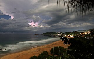
Puerto Escondido is a small port and tourist center in the municipality of San Pedro Mixtepec Distrito 22 in the Mexican state of Oaxaca. Prior to the 1930s, there was no town. The bay had been used as a port intermittently to ship coffee, but there was no permanent settlement due to the lack of potable water. The name "Puerto Escondido" had roots in the legend of a woman who escaped her captors and hid here. The Nahuatl word for this area was Zicatela, meaning “place of large thorns". Today, it refers to the area's most famous beach.
Playa Zipolite is a beach community located in San Pedro Pochutla municipality on the southern coast of Oaxaca state in Mexico between Huatulco and Puerto Escondido.

San Pedro Pochutla is a city and municipality located in the south of Oaxaca state, in southeastern Mexico next to the Pacific Ocean and is the southernmost municipality in Oaxaca. It is an important commercial, transportation and administrative hub for the Pochutla District in the east of the Costa Region. Pochutla is located at the junction of coastal Highway 200 and Highway 175 to Oaxaca, with 175 functioning as the town's main thoroughfare. Its name means "place of kapok trees ", and most of the city is built on a lakebed which was drained during the colonial period. The municipality is best known as being the home of the oceanside communities of Puerto Ángel and Zipolite.
San Agustinillo is a small fishing village and beach in the state of Oaxaca, Mexico. It is located in the municipality of Santa María Tonameca just east of the coastal communities of Mazunte and La Ventanilla. This is where the Sierra Madre del Sur mountains meet the Pacific Ocean.

Candelaria Loxicha is a town and municipality in Oaxaca in southern Mexico. The municipality covers an area of 86.8 km2. It is part of the Pochutla District in the east of the Costa Region.
San Agustín Loxicha is a town and municipality in Oaxaca in south-western Mexico. The municipality covers an area of 389.1 km². It is part of the Pochutla District in the east of the Costa Region.
San Baltazar Loxicha is a town and municipality in Oaxaca in south-western Mexico. The municipality covers an area of 58.7 km². It is part of the Pochutla District in the east of the Costa Region.
San Bartolomé Loxicha is a town and municipality in Oaxaca in south-western Mexico. The municipality covers an area of 191.4 km2. It is part of the Pochutla District in the east of the Costa Region.
San Miguel del Puerto is a town and municipality in Oaxaca in south-western Mexico. The municipality covers an area of 488.6 km². It is part of the Pochutla District in the east of the Costa Region.
San Pedro el Alto is a town and municipality in Oaxaca in south-western Mexico. The municipality covers an area of km2. It is part of the Pochutla District in the east of the Costa Region.
Santa Catarina Loxicha is a town and municipality in Oaxaca in south-western Mexico. The municipality covers an area of km². It is part of the Pochutla District in the east of the Costa Region
Santa María Colotepec is a town and municipality in Oaxaca in south-western Mexico. The municipality covers an area of 415.837 km². It is part of the Pochutla District in the east of the Costa Region.

Santa María Tonameca is a town and municipality located on the southern coast of Oaxaca, Mexico, about 268 km from the capital city of Oaxaca. It is part of the Pochutla District in the east of the Costa Region. It is a very rural area, which is best known for the beach communities of Mazunte, San Agustinillo and La Ventanilla. The National Turtle Center, a research center and aquarium is located in Mazunte, along with conservation centers for butterflies and iguanas. The town itself is the site of the largest annual festival in the area, celebrating the rescue of a cedar image of the Virgin Mary from the rubble of the town church after an earthquake on 11 May 1870.

The Costa Region or Costa Chica lies on the Pacific coast of the state of Oaxaca, Mexico, south of the more mountainous Sierra Sur inland from the coast. It includes the districts of Jamiltepec, Juquila and Pochutla.

Centro District is located in the Valles Centrales Region of the State of Oaxaca, Mexico. The district includes the state capital Oaxaca and satellite towns. The district has an average elevation of 1,550 meters. The climate is mild, with average temperatures ranging from 16°C in Winter to 25°C in spring.
Tlacolula District is located in the east of the Valles Centrales Region of the State of Oaxaca, Mexico.
Juquila District is located in the center of the Costa Region of the State of Oaxaca, Mexico, on the Pacific coast. It has an area of 5,055 km2. As of 2005 it had a total population of 134,365 of whom 33,106 spoke an indigenous language. Economic activities include agriculture and tourism. The Santuario (Sanctuary) de Juquila is a major attraction.
Loxicha Zapotec is a Zapotec language of Oaxaca, Mexico. It is one of the most populous varieties of Zapotec, and the majority of speakers are monolingual.
San Baltazar Loxicha Zapotec is a Zapotec language spoken in southern Oaxaca, Mexico. It is spoken in the towns of San Baltazar Loxicha and Santa Catarina Loxicha. It is not the same language as the other dialects spoken in towns named Loxicha, but it is in the same branch of Zapotec.

 View of Puerto Angel's wharf
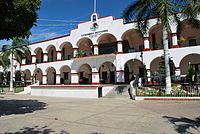 Municipal Palace, San Pedro Pochutla
 Municipal Palace, Santa María Tonameca
 Protected turtle eggs incubating in La Ventanilla


