
The Coral Sea Islands Territory is an external territory of Australia which comprises a group of small and mostly uninhabited tropical islands and reefs in the Coral Sea, northeast of Queensland, Australia. The only inhabited island is Willis Island. The territory covers 780,000 km2 (301,160 sq mi), most of which is ocean, extending east and south from the outer edge of the Great Barrier Reef and includes Heralds Beacon Island, Osprey Reef, the Willis Group and fifteen other reef/island groups. Cato Island is the highest point in the Territory.
Square kilometre or square kilometer, symbol km2, is a multiple of the square metre, the SI unit of area or surface area.
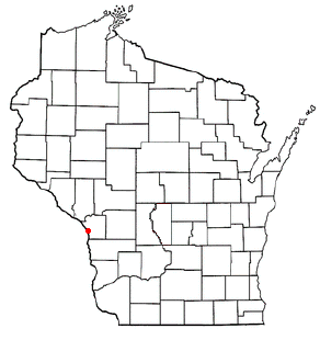
French Island is a census-designated place (CDP) in La Crosse County, Wisconsin, United States. The population was 4,207 at the 2010 census. It lies on an island of the same name, with which it is not coextensive; most of the island is part of the city of La Crosse, but all are part of the La Crosse Metropolitan Statistical Area. French Island is part of the Town of Campbell and contains all of its population, because the balance of Campbell is uninhabited.

Fangataufa is a small, low, narrow, coral atoll in the eastern side of the Tuamotu Archipelago. It was formerly known as Cockburn Island. Along with its neighboring atoll, Moruroa, it has been the site of approximately 200 nuclear bomb tests.

Flint Island is an uninhabited coral island in the central Pacific Ocean, part of the Southern Line Islands under the jurisdiction of Kiribati. In 2014 the Kiribati government established a twelve-nautical-mile exclusion zone around each of the southern Line Islands.

Wales Island is one of the uninhabited Canadian arctic islands in the Qikiqtaaluk Region of Nunavut. Located 1.5 kilometres off the Melville Peninsula, the island is situated in Committee Bay within western Gulf of Boothia. It has an area of 1,137 square kilometres.
Vanatinai Island is a volcanic island in the south-east of the Louisiade Archipelago within Milne Bay Province of Papua New Guinea. The reef fringed island is approximately 360 kilometres south-east of New Guinea and 30 kilometres south of Misima. With an area of 830 square kilometres, it is the largest island of the archipelago. Tagula town, the main settlement, is located on the north-west coast. The population was 3628 as of 2014. The principal export is copra.

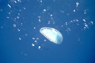
Kalpeni is an inhabited Atoll in the Union Territory of Lakshadweep, India. It has a distance of 2,079 km (1,292 mi) south of the city of Delhi.
In many countries, Kilometre Zero or similar terms in other languages is a particular location from which distances are traditionally measured. Historically, they were markers where drivers could set their odometers to follow the directions in early guide books.

Tenararo is the smallest atoll in the Acteon Group in the southeastern part of the Tuamotu Islands in French Polynesia. It is administratively a part of the Gambier Islands. It is uninhabited.

Tenarunga or Tenania, previously Narunga and formerly Minto Island is a low, wooded and uninhabited atoll in the Acteon Group in the southeastern part of the Tuamotu Islands in French Polynesia. It is administratively a part of the Gambier Islands.
Sikaiana is a small atoll 212 kilometres NE of Malaita in Solomon Islands in the south Pacific Ocean. It is almost 14 kilometres in length and its lagoon, known as Te Moana, is totally enclosed by the coral reef. Its total land surface is only 2 square kilometres. There is no safe anchorage close to this atoll, which makes it often inaccessible to outsiders.
St. François Atoll is one of two atolls of the Alphonse Group in the Seychelles that are part of the Outer Islands.
Tekokota is one of the Central Tuamotu atolls, located close to the geographic center of the archipelago.

Vahitahi, or Vaitake, is an atoll in the eastern area of the Tuamotu Archipelago, French Polynesia. Vahitahi's nearest neighbour is Akiaki, which is located 41 kilometres to the northwest.

Elasa is an island that can be found northeast of Crete in the Aegean Sea, about 3.5 nautical miles from the palm tree forest of Vai. It is rocky and uninhabited covering 1.9 square kilometres. Its highest point is 79 metres above sea level. Administratively it comes within the Itanos municipality in Lasithi.

Kamaka is an island in the Gambier Islands of French Polynesia, 11.7 km south of Mangareva within the same lagoon. Kamaka is about one kilometre in length, 700 metres wide, and has an area of 0.5 square kilometres. The highest point is 166 metres above sea level.

Lathami Conservation Park is a protected area in the Australian state of South Australia on the north coast of Kangaroo Island located in the locality of Cassini about 1 kilometre east of Stokes Bay and about 17 kilometres north of Parndana. It was proclaimed on 1 October 1987 to protect important nesting and foraging habitat for the Glossy Black Cockatoo, after which the conservation park was named.

Insular Chile, also called Las islas Esporádicas, or "the Sporadic Islands", is a scattered group of oceanic islands of volcanic origin located in the Chilean Sea, at some distance from mainland Chile, and which are under the sovereignty of Chile.
