
Chhattisgarh is a landlocked state in Central India. It is the ninth largest state by area, and with a population of roughly 30 million, the seventeenth most populous. It borders seven states – Uttar Pradesh to the north, Madhya Pradesh to the northwest, Maharashtra to the southwest, Jharkhand to the northeast, Odisha to the east, Andhra Pradesh and Telangana to the south. Formerly a part of Madhya Pradesh, it was granted statehood on 1 November 2000 with Raipur as the designated state capital.

Kanjirappally is a taluk and a town in Kottayam district situated about 38 km (24 mi) away from the district capital, in the state of Kerala, in southwestern India.

Raigarh district is a district of the central Indian state of Chhattisgarh. Raigarh is the district headquarters.

Raigarh is a city in northern Chhattisgarh known as the 'Cultural capital of Chhattisgarh'; Raigarh is famous for its dance form “Kathak” and classical music; Raigarh is also known as Sanskritidhani.

Payyoli is a municipality town on the Malabar Coast of Kozhikode district in the South Indian state of Kerala. Payyoli is famous for being the hometown of athlete PT Usha, who is nicknamed as the Payyoli Express. It is a town in Quilandy Taluk, Kozhikode District.
Dharamjaygarh is a town and a nagar panchayat in Raigarh District in the state of Chhattisgarh, India. Major languages spoken are Hindi and Chhattisgarhi, with a little Odia, Bengali and English. Laljeet Singh Rathia is a current MLA of the Dharamjaigarh constituency.
Sarangarh is a New District in the Indian state of Chhattisgarh.
Selaiyur is a suburb of Chennai, India, located on the Tambaram–Velachery Road in the Chennai Metropolitan Area. It was once called Silaiyur. Neighbouring areas include Tambaram, Madambakkam, Rajakilpakkam, Sembakkam, Chitlapakkam and Medavakkam.Once a part of Pallavaram Municipality,it was merged into Tambaram Municipal Corporation in 2021.
National Highway 153, formerly NH-216, is a national highway in India. It is a spur road of National Highway 53. NH-153 traverses the state of Chhattisgarh in India.
Korwa, or Kodaku/Koraku (Korku), is a Munda language of India spoken in Chhattisgarh and Jharkhand.
Raigarh Airport is located near Kondatarai, 9 km (5.6 mi) south of Raigarh, in Chhattisgarh, India. The air strip is used mainly for small aircraft and choppers.

Raigarh was a princely state in India during the British Raj. The state was ruled by the Gond dynasty of Gond clan.
Chhattisgarh Air link was a private non-scheduled airline based in Chhattisgarh, India. It was a subsidiary of Chhattisgarh Aviation Academy. It flew non-scheduled and scheduled flights operated on a charter and individual ticket basis. The airline started operations in December 2012. As of April 2019, the airline's website is defunct.
Madhu Bai Kinnar is the mayor of Raigarh in Chhattisgarh, India. Running as an independent candidate, Madhu won the mayor election of the Raigarh Municipal Corporation, securing 33,168 votes and defeating the nearest rival, the ruling party BJP's Mahaveer Guruji, by 4,537 votes. She is India's only openly transgender mayor.

Vasheni is a village in Uran Taluka, Maharashtra state, India. The most common occupations in Vasheni are farmers, fishers and teachers. Uran, Pen and Panvel are the nearest towns or cities. The population of the village is 3,700. There are mainly Four sectors (nickname-Aali)
- Varchi Aali
- Khalchi Aali
- Tep Aali
- Belpada
- Maath Aali
- Dandeshwar
Bhikampali is a medium-sized village in the Jharsuguda district of Odisha, India. It is situated on the banks of Saan-kelo River in the foothill of Chhelia Pahad. The village is located at a distance of 60 km from the district headquarter of Jharsuguda. It is within the Brajarajnagar assembly constituency, and the Bargarh Parliament constituency. As of 2011 census, its population is 920.
Thammanwal is a village in Jalandhar district of Punjab State, India. It is located 2.5 km from Mao Sahib, 12.9 km from Phillaur, 40.6 km from district headquarter Jalandhar and 133 km from state capital Chandigarh. The village is administrated by a sarpanch who is an elected representative of village as per Panchayati raj (India). Roshan Kainth hometown
Beed Kh. village is located in Khalapur Tehsil of Raigad district in Maharashtra, India. It is situated 13 km away from sub-district headquarter Khalapur and 66 km away from district headquarter Alibag. Beed Khurd is the gram panchayat of Beed Kh village.
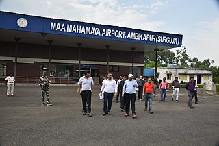
Maa Mahamaya Ambikapur Airport or Ambikapur Airport is located at Darima, 12 km (7.5 mi) south of Ambikapur, in Chhattisgarh, India. The airport serves Ambikapur, one of the major city of Chhattisgarh state. It also serves the nearby towns of Surajpur, Baikunthpur, Bhatgaon, Mainpat, Sitapur, Brishrampur, Balrampur, Ramanujganj, etc. therefore this airport provides air connectivity to entire Northern Chhattisgarh.

