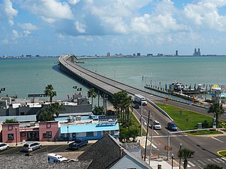
South Padre Island is a resort town in Cameron County, Texas, United States. It is part of the Brownsville–Harlingen Metropolitan Statistical Area. The population was 2,816 at the 2010 census. The town is located on South Padre Island, a barrier island along the Texas Gulf Coast accessible via the Queen Isabella Causeway from the town of Port Isabel. South Padre Island is named after José Nicolás Ballí, a Catholic priest and settler.
U.S. Route 190 (US 190) is an east–west United States Highway in Louisiana and Texas. Segments of US 190 will be upgraded to Interstate 14 (I-14); the first 24.8-mile (39.9 km) segment was opened on January 26, 2017.
U.S. Route 259 is a north–south spur of U.S. Route 59 that runs for 250 miles (400 km) through rural areas of northeast Texas and southeast Oklahoma. The highway's southern terminus is near Nacogdoches, Texas at an interchange with its parent route, US 59. Its northern terminus is in the Ouachita Mountains, about 15 miles (24 km) south of Heavener, Oklahoma where it reunites with US 59. For most of its length, US 259 lies 30–50 miles (48–80 km) to the west of its parent route.
Route 1A, largely signed as Scenic 1A, is a 33.3-mile (53.6 km) long numbered state highway located in Washington County, Rhode Island, United States. The route, which parallels U.S. Route 1 for its entire length, has four distinct sections connected by US 1, two of which require median u-turn ramps to cross US 1. It travels through five towns in Washington County: Westerly, Charlestown, South Kingstown, Narragansett, and North Kingstown.
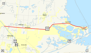
State Highway 100 is a Texas state highway that runs 24 miles (39 km) between "Russeltown" and Port Isabel. It was designated in 1926 along its current route. Its western terminus is at Interstate 69E/U.S. Highway 77/83 and ends at the western end of the Queen Isabella Memorial Causeway at Port Isabel. The route continues as Texas Park Road 100 east and north to a dead end on South Padre Island.

State Route 100 is a primary state highway in the U.S. state of Virginia. The state highway runs 53.31 miles (85.79 km) from U.S. Route 221 in Hillsville north to SR 61 in Narrows. SR 100 is one of the major highways of the New River Valley, connecting Narrows and Pearisburg in Giles County with Dublin, Pulaski, and Interstate 81 (I-81) in Pulaski County.

Park Road 27 or PR 27 is a Texas park road that runs from Fannin to the Fannin Battleground State Historic Site, which is the site of the Battle of Coleto. PR 27 was originally SH 162 and briefly Spur 91 before gaining its current designation in 1940.
US Highway 2 (US 2) is a part of the United States Numbered Highway System that runs from Everett, Washington, to St. Ignace, Michigan. In Wisconsin, the highway enters runs east–west across the northwestern part of the state and re-enters the state in the northeast part. It runs from the Richard I. Bong Memorial Bridge over the Saint Louis Bay at Superior, where it enters from Minnesota, east to the Michigan state line near Hurley. Further east, US 2 re-enters Wisconsin from Michigan in Florence County and briefly traverses that county before re-entering Michigan. US 2 is a Wisconsin Corridors 2020 Connecting route east of its concurrency with US 53. The section concurrent with US 53 is a Wisconsin Corridors 2020 Backbone route.

State Highway 361 is a state highway in San Patricio and Nueces counties that runs from Gregory in southern Texas, near Corpus Christi, east and south to Padre Island on the Gulf of Mexico coast.

State Highway 290 is a state highway maintained by the Texas Department of Transportation (TxDOT) that runs from Interstate 10 near Sheffield east to another connection with I-10 about 20 miles (32 km) east of Sheffield. The 24.5-mile (39.4 km) route was designated in 1992 as a replacement for U.S. Route 290 when that route was shortened to end near Junction. The route connects I-10 to Sheffield and Fort Lancaster State Historic Site and overlays a portion of SH 349.
State Highway 358 is a Texas state highway that runs along the southern edge of Corpus Christi. The access road for Highway 358 is known as South Padre Island Drive (SPID). The official division is FM 665.
Route 152 is a state highway in the U.S. states of Rhode Island and Massachusetts. The highway begins at U.S. Route 1A and Route 114 in East Providence, Rhode Island. After crossing into Massachusetts, Route 152 runs 14.8821 miles (23.9504 km) through Seekonk, Attleboro, and North Attleboro to US 1 in Plainville.
Interstate 35 (I-35) is an Interstate Highway that stretches from Laredo, Texas, in the south to Duluth in the north. The portion of it through Missouri travels nearly 115 miles (185 km) from just south of Kansas City, through the Downtown Loop, and across the Missouri River before leaving the downtown area. North of Kansas City, the highway travels north-northeast towards the Iowa state line near Eagleville, paralleling U.S. Route 69.
Highway 10 is a road on St. John in the U.S. Virgin Islands. Usually referred to as Center Line Road by locals, as it runs through the center of the island, Highway 10 runs from Highway 20 in Cruz Bay across St. John, entering Virgin Islands National Park along the way. Route 10 has three auxiliary routes, Highway 104, Highway 107, and Highway 108.

Ranch Road 1 is a Ranch Road located in Gillespie and Blanco counties, in the central region of the U.S. state of Texas. The highway is approximately 6.6 miles (10.6 km), and begins at U.S. Route 290 in Stonewall, running along the Pedernales River through Lyndon B. Johnson National Historical Park, the late President Lyndon Johnson's former ranch, and through Lyndon B. Johnson State Park and Historic Site, before terminating at US 290 near Hye. The road, designated in 1963, is the only road in the state that TxDOT has designated as a "Ranch Road". In the earliest days of the state highway system, the route was a part of State Highway 20, and was later part of US 290 before that highway was relocated to the south.
Park Road 33 is a park road in north central Texas that runs from Caddo to Possum Kingdom State Park.

The Laguna Madre is a long, shallow, hypersaline lagoon along the western coast of the Gulf of Mexico in Nueces, Kenedy, Kleberg, Willacy and Cameron Counties in Texas, United States. It is one of seven major estuaries along the Gulf Coast of Texas. The roughly 20-mile (32 km) long Saltillo Flats land bridge divides it into Upper and Lower lagoons joined by the Intracoastal Waterway, which has been dredged through the lagoon. Cumulatively, Laguna Madre is approximately 130 miles (209 km) long, the length of Padre Island in the US. The main extensions include Baffin Bay in Upper Laguna Madre, Red Fish Bay just below the Saltillo Flats, and South Bay near the Mexican border. As a natural ecological unit, the Laguna Madre of the United States is the northern half of the ecosystem as a whole, which extends into Tamaulipas, Mexico ca. 144 miles (233 km.) south of the US border, to the vicinity of the Rio Soto La Marina and the town of La Pesca, extending ca.275 miles (442.57 km.) through USA and Mexico all total.
Park Road 1 is a Park Road located in Bastrop and Buescher state parks, in the central region of the U.S. state of Texas. The highway is approximately 33.6 miles (54.1 km) long, and passes through mainly rural park land. PR 1 also includes most main roads in the two parks. Because of this, the highway has been divided into five different routes; they are PR 1A, 1B, 1C, 1D, and 1E. PR 1C makes up most of the route, while three of the segments are less than a mile long. The route was first drafted by the Civilian Conservation Corps (CCC) in 1933, as a scenic drive between the two parks. It was designated in 1937 as one of the state's originally designated Park Roads and has been extended and altered multiple times since.
Park Road 1836 (PR 1836), also known as San Jacinto Battleground State Park Road and Juan N. Seguin Boulevard, is a Park Road in southeast Texas. The route is 7.234 miles (11.642 km) long, and connects San Jacinto Battleground State Historic Site to Independence Parkway in Houston in southeast Harris County. The designation is given to multiple roads on the park grounds. The road was designated as PR 9 in 1939 before receiving its current designation in 1960.
Park Road 37 is a state highway located in the Texas Hill Country. The highway runs from Bandera County Park at the shores of Medina Lake in Lakehills to SH 16 northwest of Helotes. PR 37 has been noted as an excellent drive by motorcyclists for its views, tight bends and hills.

