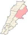
Baalbek is a city located east of the Litani River in Lebanon's Beqaa Valley, about 67 km (42 mi) northeast of Beirut. It is the capital of Baalbek-Hermel Governorate. In 1998, Baalbek had a population of 82,608, mostly Shia Muslims, followed by Sunni Muslims and Christians. The town is known for its historical sites and tourist attractions, including several ancient Roman temples, a Great Mosque from the Umayyad period, and a Roman quarry site named Hajar al-Hibla.

Beqaa is a governorate in Lebanon and one of the eight districts of the country. It is located in the eastern part of Lebanon and borders with Syria. The capital of the district is the city of Zahlé.

The Beqaa Valley is a fertile valley in eastern Lebanon and its most important farming region. Industry, especially the country's agricultural industry, also flourishes in Beqaa. The region broadly corresponds to the Coele-Syria of classical antiquity.
El Ain, Al Ain, or Ain is a village at an elevation of 1,000 metres (3,300 ft) on a foothill of the Anti-Lebanon Mountains in the Baalbek District of the Baalbek-Hermel Governorate, Lebanon. It is famous for agriculture and trade, located on the highway connecting Syrian borders and the Hermel area with Chtaura and Beirut.

Qaa, El Qaa, Al Qaa, Qaa Baalbek or Masharih al-Qaa is a town in Baalbek-Hermel Governorate, Lebanon. A 2010 report stated that population of the settlement was 500, all Lebanese Maronites.

The Temple of Bacchus is part of the Baalbek archaeological site, in Beqaa Valley region of Lebanon. The temple complex is considered an outstanding archaeological and artistic site of Imperial Roman Architecture and was inscribed as a UNESCO World Heritage Site in 1984. This monument to Bacchus is one of the best preserved and grandest Roman temple ruins; its age is unknown, but its fine ornamentation can be dated to the second century CE.
Sawiri or Sawairy or es-Sawairi (الصويري) is a town in the eastern part of Lebanon.
Deir El Ahmar is a Lebanese town, located 100km from Beirut and 22km northwest of Baalbek in the Bekaa Valley in Lebanon.

Iaat is a town and municipality located approximately 5 kilometers northwest of Baalbek, in the Beqaa Valley of Lebanon. The town is famed for its Corinthian column, the Iaat column. This is a single column of unknown date, approximately halfway between Baalbek and Qasr el Banat, with a cartouche on the 6th drum but no inscription.

Duris is a village located approximately 3 km (2 mi). southwest of Baalbek in the Bekaa Valley, Lebanon. It is the site of a 13th-century Muslim shrine and a necropolis from the late Roman Imperial period that is currently undergoing archaeological investigation.

Zahlé is a city in eastern Lebanon, and the capital and largest city of Beqaa Governorate, Lebanon. With around 150,000 inhabitants, it is the third-largest city in Lebanon after Beirut and Tripoli and the fourth-largest taking the whole urban area.

Ras Baalbek is a village in the northern Beqaa Valley in Lebanon.
Arsal, is a town and municipality situated east of Labweh, 124 kilometres (77 mi) northeast of Beirut, in Baalbek District of Baalbek-Hermel Governorate, Lebanon. The population is predominantly Sunni Muslim.
Nahle ), is a village situated 6 kilometres (3.7 mi) northeast of Baalbek in Baalbek District, Baalbek-Hermel Governorate, Lebanon. It has the ruins of a Roman temple.

The Harfush dynasty was a dynasty that descended from the Khuza'a tribe, which helped, during the reign of Muhammad, in the conquest of Syria. The Harfush are considered the best-known Shiite group in the history of Ottoman-period Lebanon, when they controlled the Baalbek District and several parts of the Bekaa Valley. Their being Shiaa was a major factor in the rivalry between the Harfushes and the Lebanese Druze Maan family.
Bodai is a Lebanese town in Baalbek District, Baalbek-Hermel Governorate, situated west of the Litani River in the foothills of Mount Lebanon. Bodai is located 15 km northwest of the ancient city of Baalbek and 26 km from the Lebanese–Syrian border and is 90 kilometers (55.926 mi) away from the capital of Beirut. Bodai, which sits in the foothills of the Mount Lebanon range, has views across the Beqaa Valley toward the city of Baalbek, and the Anti-Lebanon range that divides Lebanon from Syria.

The Temple of Jupiter is a colossal Roman temple, the largest of the Roman world after the Temple of Venus and Roma in Rome. It is situated at the Baalbek complex in Baalbek, Lebanon, It is unknown who commissioned or designed the temple, nor exactly when it was constructed. It is situated at the western end of the Great Court of Roman Heliopolis, on a broad platform of stone raised another 7 m (23 ft) above the huge stones of the foundation, three of which are among the heaviest blocks ever used in a construction. Cultic activity had long taken place at the site; the temple presumably replaced an earlier one, possibly using the same foundation.

Akkar Governorate is the northernmost governorate of Lebanon. It comprises the single district of Akkar, which in turn is subdivided into 121 municipalities. The capital is at Halba. It covers an area of 788 km2 (304 sq mi) and is bounded by the Mediterranean Sea to the west, North Governorate to the south, Baalbek-Hermel Governorate to the southeast, and the Syrian governorates of Tartus and Homs to the north and northeast. The governorate's western coastal plain constitutes Lebanon's second largest agricultural region after the Beqaa Valley, while the east features forested mountains that have been considered for protection as a national park.

Baalbek-Hermel is a governorate of Lebanon. It comprises the districts of Baalbek and Hermel, which in turn are subdivided into a total of 74 municipalities. The capital is at Baalbek. The governorate covers an area of 3,009 km2 (1,162 sq mi) and is bounded by Akkar Governorate to the northwest, North Governorate to the west, Keserwan-Jbeil Governorate and Mount Lebanon Governorate to the southwest, Beqaa Governorate to the south, and the Syrian governorates of Homs and Rif Dimashq to the northeast and southeast. The governorate occupies the northern portion of the Beqaa Valley, Lebanon's most important agricultural area.
Brital is a village located in the Baalbek District of the Baalbek-Hermel Governorate in Lebanon.


