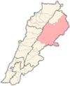
Baalbek is a city located east of the Litani River in Lebanon's Beqaa Valley, about 67 km (42 mi) northeast of Beirut. It is the capital of Baalbek-Hermel Governorate. In 1998, the city had a population of 82,608. Most of the population consists of Shia Muslims, followed by Sunni Muslims and Christians; in 2017, there was also a large presence of Syrian refugees.

The Beqaa Valley is a fertile valley in eastern Lebanon and its most important farming region. Industry, especially the country's agricultural industry, also flourishes in Beqaa. The region broadly corresponds to the Coele-Syria of classical antiquity.

Al-Zabadani or Az-Zabadani is a city and popular hill station in southwestern Syria in the Rif Dimashq Governorate, close to the border with Lebanon. It is located in the center of a green valley surrounded by high mountains at an elevation of around 1,100 m.

Al-Nabi Shayth is a village in eastern Lebanon, located in the Beqaa Valley and Baalbek District. The village's name comes from the considered burial-site of Seth the son of Adam. A mosque was built on the burial site and it contains the grave of Seth inside the mosque. The village is also the hometown of former leader and co-founder of Hezbollah, Abbas al-Musawi, as well as the hometown of other senior Hezbollah leaders such as the late Fuad Shukr. The village of Al-Nabi Sheeth is predominantly inhabited by people with the surnames Helbawi, Al-Moussawi, Hazimeh and Chokr.

Maroun al-Ras is a Lebanese village nestled in Jabal Amel in the district of Bint Jbeil in the Nabatiye Governorate in southern Lebanon. It is located around 120 km (75 mi) south east of Beirut, roughly one km (0.62 mi) from the border with Israel.

Qaa, El Qaa, Al Qaa, Qaa Baalbek or Masharih al-Qaa is a town in Baalbek-Hermel Governorate, Lebanon. A 2010 report stated that population of the settlement was 500, all Lebanese Maronites.
Deir El Ahmar is a Lebanese town, located 100km from Beirut and 22km northwest of Baalbek in the Bekaa Valley in Lebanon.

Iaat is a town and municipality located approximately 5 kilometers northwest of Baalbek, in the Beqaa Valley of Lebanon. The town is famed for its Corinthian column, the Iaat column. This is a single column of unknown date, approximately halfway between Baalbek and Qasr el Banat, with a cartouche on the 6th drum but no inscription.

Duris is a village located approximately 3 km (2 mi). southwest of Baalbek in the Bekaa Valley, Lebanon. It is the site of a 13th-century Muslim shrine and a necropolis from the late Roman Imperial period that is currently undergoing archaeological investigation.
Karak is a village in the municipality of Zahlé in the Zahle District of the Beqaa Governorate in eastern Lebanon. It is located on the Baalbek road close to Zahle. Karak contains a sarcophagus claimed by the locals to be the tomb of Noah. The inhabitants of Karak are Melkites, Maronites and Shia Muslims.

Zahlé is a city in eastern Lebanon, and the capital and largest city of Beqaa Governorate, Lebanon. With around 150,000 inhabitants, it is the third-largest city in Lebanon after Beirut and Tripoli and the fourth-largest taking the whole urban area.

Labweh, Laboué, Labwe or Al-Labweh is a village at an elevation of 950 metres (3,120 ft) on a foothill of the Anti-Lebanon Mountains in Baalbek District, Baalbek-Hermel Governorate, Lebanon.
Ain Harcha is a village situated in the Rashaya District and south of the Beqaa Governorate in Lebanon. It is located east of Mount Hermon close to the Syrian border south of Dahr El Ahmar. The village is home to a Roman temple.
Beit Lahia is a village situated in the Rashaya District and south of the Beqaa Governorate in Lebanon. It is located near Mount Hermon and the Syrian border, not far from Rashaya, Aaiha and Kfar Qouq.
Arsal, is a town and municipality situated east of Labweh, 124 kilometres (77 mi) northeast of Beirut, in Baalbek District of Baalbek-Hermel Governorate, Lebanon. The population is predominantly Sunni Muslim.
Kanaker is a village in southern Syria, administratively part of the Rif Dimashq Governorate, located southwest of Damascus. Nearby localities include Sa'sa' to the west, Beit Saber to the northwest, Khan al-Shih to the north, Zakiyah, al-Taybah, Khan Dannun and al-Kiswah to the northeast, Deir Ali and Jubb al-Safa to the east, Ghabaghib to the southeast, Kafr Nasej and Deir al-Adas to the south and Jabah to the southwest. According to the Syria Central Bureau of Statistics, Kanaker had a population of 13,950 at the 2004 census, making it the largest locality in the nahiyah ("subdistrict") of Sa'sa'. Kanaker marks the western boundary of the Marj al-Suffar plain, south of the right bank of the al-A'waj river.
The Lebanese–Syrian border clashes were a series of clashes on the Lebanon–Syria border caused by the ongoing Syrian Civil War.
Bodai is a Lebanese town in Baalbek District, Baalbek-Hermel Governorate, situated west of the Litani River in the foothills of Mount Lebanon. Bodai is located 15 km northwest of the ancient city of Baalbek and 26 km from the Lebanese–Syrian border and is 90 kilometers (55.926 mi) away from the capital of Beirut. Bodai, which sits in the foothills of the Mount Lebanon range, has views across the Beqaa Valley toward the city of Baalbek, and the Anti-Lebanon range that divides Lebanon from Syria.

The Qalamoun offensive (2017) was a military operation launched by Hezbollah, the Syrian Armed Forces, and later the Lebanese Armed Forces, against members of Tahrir al-Sham and the Islamic State of Iraq and the Levant on the Lebanon–Syria border. The Lebanese Army denied any coordination with Hezbollah or the Syrian Arab Army.
Chlifa is a local authority in the Baalbek District of the Baalbek-Hermel Governorate in Lebanon.