
The Red River, also known as the Hong River and Sông Cái in Vietnamese, and the Yuan River in Chinese, is a 1,149-kilometer (714 mi)-long river that flows from Yunnan in Southwest China through northern Vietnam to the Gulf of Tonkin. According to C. Michael Hogan, the associated Red River Fault was instrumental in forming the entire South China Sea at least as early as 37 million years before present. The name red and southern position in China are associated in traditional cardinal directions. The river is relatively shallow, and carries a lot of reddish silt along its way, appearing red brown in colour.
Articles related to Vietnam and Vietnamese culture include:

Phú Quốc is the largest island in Vietnam. Phú Quốc and nearby islands, along with the distant Thổ Chu Islands, are part of Kiên Giang Province as Phú Quốc City, this is Vietnam's first island city. The island has a total area of 589.27 km2 (227.52 sq mi) and a permanent population of approximately 179,480 people in 2020. Located in the Gulf of Thailand, the island city of Phú Quốc includes the island proper and 21 smaller islets. Dương Đông ward, located on the island's west coast, is the island's administrative centre and largest town. The other ward is An Thới on the southern tip of the island.

Phú Thọ is a province in northern Vietnam. Its capital is Việt Trì, which is 80 kilometres (50 mi) from Hanoi and 50 kilometres (31 mi) from Nội Bài International Airport. The province covers an area of 3,534.56 km2 (1,364.70 sq mi) and, as of 2023, it had a population of 1,530,800.

Yên Bái is a province located in Northwest Vietnam. It shares borders with six provinces which are Hà Giang province, Lào Cai province, Lai Châu province, Sơn La province, Phú Thọ province, and Tuyên Quang province. The province covers an area of about 6,893 km2 (2,661 sq mi) and as of 2022 it had a population of 847,250 people.
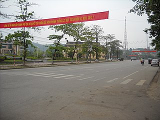
Yên Bái is a city in Vietnam. It is the capital of Yên Bái Province, in the north-east region of Vietnam. The city borders Yên Bình District and Trấn Yên District. The city is a settlement along the banks of the Red River, approximately 183 km northwest of Hanoi. It is one of the important trading hubs between the highlands and the lowlands of Northern Vietnam.

Hạ Long is a first-class provincial city and the capital city of Quảng Ninh province, Vietnam. It was founded in 1993, when the old capital, Hòn Gai, was merged with Bãi Cháy, the main tourist area. The city mainly lies on Hạ Long Bay, and is located at about 178 km (111 mi) east of Hà Nội. The city's population in 2019 was 270,054.

Việt Trì is the capital city of Phú Thọ Province in the Northeast region of Vietnam. In 2010, the city had a population of 260,288. The city covers an area of 110 square kilometres (42 sq mi). Việt Trì is also the economic centre of the province and contains many industrial firms and service industries.

Operation Lorraine was a French military operation of the First Indochina War.

The Yên Bái mutiny was an uprising of Vietnamese soldiers in the French colonial army on 10 February 1930. This took place in collaboration with civilian supporters who were members of the Việt Nam Quốc Dân Đảng.
Việt Bắc is a region of Vietnam north of Hanoi that served as the Việt Minh's base of support during the First Indochina War (1946–1954).

Ba Vì is a district of Hanoi, Vietnam. Ba Vì district was established on July 26, 1968.
Phổ Yên is a provincial city of Thái Nguyên Province in the northeastern region of Vietnam. As of 2021, the city had a population of 231,363. The city covers an area of 258.42 km².

Cẩm Khê is a mountainous district in western Phú Thọ province, Vietnam. The district borders Hạ Hòa district to the north, Tam Nông district to the south, Yên Lập district to the west, and Thanh Ba district to the east. It covers an area of 234.2 square kilometres.

Visitors to Vietnam must obtain either an e-Visa or a visa in advance, unless they are citizens of one of the visa-exempt countries.
Nguyen Thi Bac (1908–1943), also known as Co Bac, was a Vietnamese revolutionary fighter. She is one of the leaders of the Yen Bai mutiny.

The October 2017 Vietnam tropical depression, also known officially by its designation as Tropical Depression 23W, was a weak but deadly system that brought torrential rainfall and extreme flooding over northern and central Vietnam in October 2017. The depression formed on October 7, located to the northwest of Luzon, Philippines. The system moved in a general westward direction as it steadily intensified. Despite being forecast to strengthen into a tropical storm, 23W failed to reach this intensity, due to lack of organization as it made landfall in Hà Tĩnh Province on October 10.
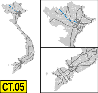
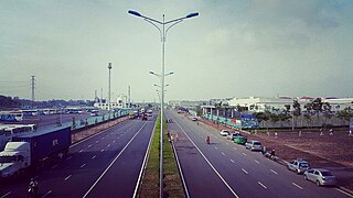
The Hanoi–Lao Cai Expressway Another name Noi Bai–Lao Cai Expressway is an expressway section of the Expressways of Vietnam, 265 km long and has its starting point at the intersection of National Highway 18 with National Highway 2 in Thanh Xuân commune, Sóc Sơn district], Hanoi city and the end point at Duyên Hải ward, Lào Cai, Lào Cai province, connecting with G8011 Kaiyuan–Hekou Expressway at Lào Cai International Border Gate. This Expressway is part of the Asian Highway Network (AH14) and Transport infrastructure development project Kunming–Hanoi–Hai Phong economic corridor.

