The Isle of Man had become separated from Great Britain and Ireland by 6500 BC. It appears that colonisation took place by sea sometime during the Mesolithic era. The island has been visited by various raiders and trading peoples over the years. After being settled by people from Ireland in the first millennium AD, the Isle of Man was converted to Christianity and then suffered raids by Vikings from Norway. After becoming subject to Norwegian suzerainty as part of the Kingdom of Mann and the Isles, the Isle of Man later became a possession of the Scottish and then the English crowns.
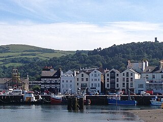
Ramsey is a coastal town in the north of the Isle of Man. It is the second largest town on the island after Douglas. Its population is 7,845 according to the 2016 Census. It has one of the biggest harbours on the island, and has a prominent derelict pier, called the Queen's Pier. It was formerly one of the main points of communication with Scotland. Ramsey has also been a route for several invasions by the Vikings and Scots.
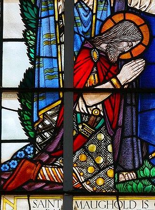
Maughold is venerated as the patron saint of the Isle of Man. Tradition states that he was an Irish prince and captain of a band of freebooters who was converted to Christianity by Saint Patrick. His feast day is 25 April. His original name is unclear, but was probably adapted from Bishop MacCaille of Croghan, County Offaly, who received Brigit of Kildare into religious life

Philip Moore Callow Kermode, was a Manx antiquarian, historian and naturalist.

Andreas or Kirk Andreas is a village on the Isle of Man, lying in the north of the island, 5 km from the island's second town, Ramsey. There is a large, and nowadays little used, airfield in the vicinity.
The Isle of Man has had a number of windmills over the centuries. They were mostly threshing mills, with a few corn mills.
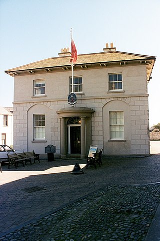
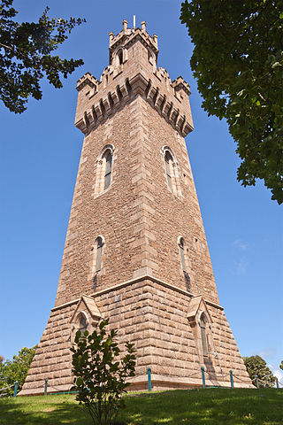
Parliament Square, Ramsey is situated between the 23rd and 24th Milestone road-side markers on the Snaefell Mountain Course used for the Isle of Man TT Races on the junction of the primary A3 Castletown to Ramsey road, the A9 Ramsey to Andreas road and A2 Douglas to Ramsey road situated in the town of Ramsey in the parish of Lezayre in the Isle of Man.

Ramsey Hairpin is a point on the Snaefell Mountain Course used for the Isle of Man TT races on the Snaefell Mountain Road, designated as A18, in the parish of Maughold in the Isle of Man.
Victoria Tower is a monument in Saint Peter Port, Guernsey, erected in honor of a visit by Queen Victoria and Prince Albert to the island in 1846.

Tower Bends is a point on the Snaefell Mountain Course used for the Isle of Man TT races on the Snaefell Mountain Road, designated A18, in the parish of Maughold in the Isle of Man.

Waterworks, Isle of Man, sometimes known as Waterworks Corner, is a point on the Snaefell Mountain Course used for the Isle of Man TT races on the Snaefell Mountain Road, designated as A18, in the parish of Maughold in the Isle of Man.

Abergeldie Castle is a four-floor tower house in Crathie and Braemar parish, SW Aberdeenshire, Scotland. It stands at an altitude of 840 feet (260 m), on the south bank of the River Dee, five miles (8 km) west of Ballater, and about two miles (3 km) east of the royal residence of Balmoral Castle. Behind it rises Creag nam Ban, a rounded granite hill about 527 metres (1,729 ft) high, and across the river to its front is the cairn-crowned Geallaig Hill, rising to 743 metres (2,438 ft).

SS (RMS) Peveril (I) No. 76307 – the first vessel in the company's history to be so named – was a packet steamer which was operated by the Isle of Man Steam Packet Company until she sank off Douglas following a collision with SS Monarch in 1899.
This is a list of Registered Buildings and Conservation Areas of the Isle of Man. It includes buildings and structures in the Isle of Man designated by Isle of Man's Department of Environment, Food and Agriculture (DEFA) "as having special architectural or historical interest". Over 250 buildings and structures are listed, and 275 more have been identified as having potential for listing. It also lists the 21 Conservation Areas, historic districts" which protect "period"-type architecture, quality of building materials, relationships of enclosures and open spaces, and other aspects of the look and feel of historic buildings and areas.

The Bahama Bank Lightship was a Lightvessel stationed on the Bahama Bank east of Ramsey Bay, Isle of Man.
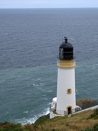
Maughold Head Lighthouse is an active 20th century lighthouse, located on the headland of the same name at the southern end of Ramsey Bay on the eastern coast of the Isle of Man. Completed in 1914, it was designed by David A and Charles Stevenson.
54 Air-Sea Rescue Marine Craft Unit was a Royal Air Force Air-Sea Rescue Unit based on the Isle of Man which operated watercraft in support of RAF operations. The unit was active from the outbreak of the Second World War until the 1960s and consisted of RAF rescue launches being based around the Island at its priciple ports; Douglas, Castletown, Peel and Ramsey.
John William Radcliffe, more commonly known as Bill Radcliffe, or also Illiam y Radlagh, was a Manx language activist, author, and teacher who was involved with the revival of the Manx language on the Isle of Man in the 20th century. His work recording the last native speakers of the language with the Irish Folklore Commission helped to ensure that a spoken record of the Manx language survived.
Constance Radcliffe was a Manx historian who wrote primarily about the history of the parish of Maughold and the town of Ramsey, both in the north of the Isle of Man. In 1989 Radcliffe was awarded the Reih Bleeaney Vanannan in recognition of her contribution to Manx culture, and was a recipient of the MBE in 1996.

Cashtal yn Ard(Castle of the Heights) is a Neolithic chambered tomb in Cornaa, in the parish of Maughold in the Isle of Man. It is situated on a low hill overlooking much of the surrounding parish of Maughold and across to the Lake District in England. The cairn was excavated in the 1930s and again in 1999. It is one of the most significant megalithic tombs on both the Isle of Man and Britain.

